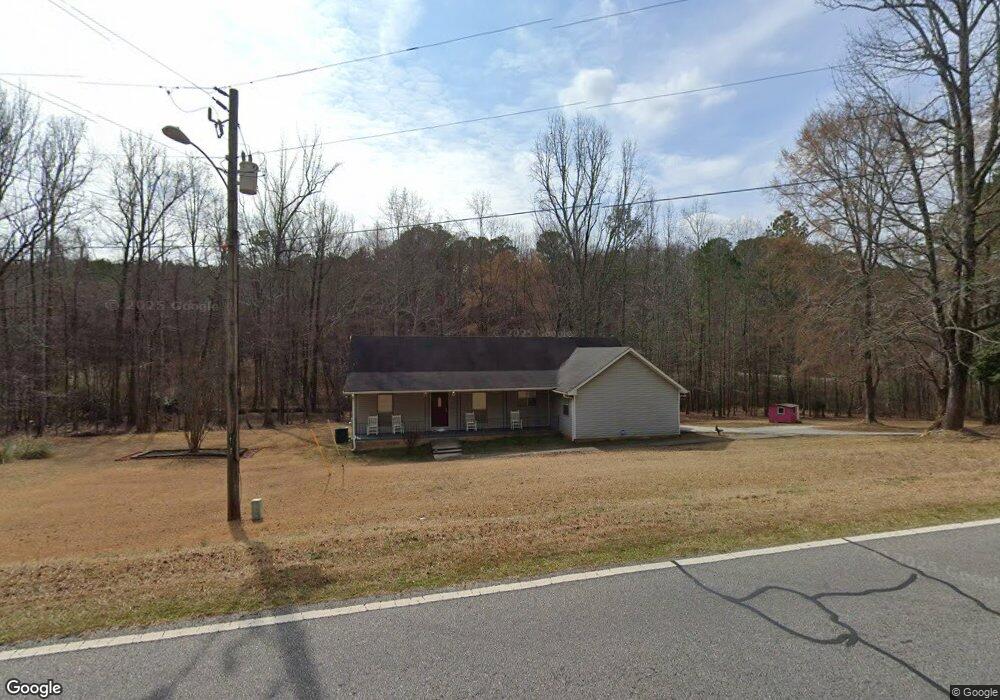
285 Nowhere Rd Athens, GA 30601
Estimated Value: $283,407 - $305,000
--
Bed
1
Bath
1,654
Sq Ft
$178/Sq Ft
Est. Value
About This Home
This home is located at 285 Nowhere Rd, Athens, GA 30601 and is currently estimated at $294,102, approximately $177 per square foot. 285 Nowhere Rd is a home located in Clarke County with nearby schools including Fowler Drive Elementary School, Coile Middle School, and Cedar Shoals High School.
Ownership History
Date
Name
Owned For
Owner Type
Purchase Details
Closed on
Jun 6, 2011
Sold by
Moss Colenia V
Bought by
Hitchcock Colenia V
Current Estimated Value
Purchase Details
Closed on
Dec 31, 1999
Sold by
First National Bank Of Chicago The As
Bought by
Moss Colenia V
Purchase Details
Closed on
Jun 1, 1999
Sold by
Locklin James R
Bought by
First National Bank Of Chicago The As
Purchase Details
Closed on
Jun 28, 1996
Sold by
North American Timberlands Inc
Bought by
Locklin James R
Purchase Details
Closed on
Dec 19, 1994
Sold by
Pierce Comer C Jr Etal
Bought by
North American Timberlands Inc
Create a Home Valuation Report for This Property
The Home Valuation Report is an in-depth analysis detailing your home's value as well as a comparison with similar homes in the area
Home Values in the Area
Average Home Value in this Area
Purchase History
| Date | Buyer | Sale Price | Title Company |
|---|---|---|---|
| Hitchcock Colenia V | -- | -- | |
| Moss Colenia V | $91,000 | -- | |
| First National Bank Of Chicago The As | $86,500 | -- | |
| Locklin James R | $7,500 | -- | |
| North American Timberlands Inc | -- | -- |
Source: Public Records
Tax History Compared to Growth
Tax History
| Year | Tax Paid | Tax Assessment Tax Assessment Total Assessment is a certain percentage of the fair market value that is determined by local assessors to be the total taxable value of land and additions on the property. | Land | Improvement |
|---|---|---|---|---|
| 2024 | $1,646 | $96,469 | $15,064 | $81,405 |
| 2023 | $499 | $87,456 | $11,836 | $75,620 |
| 2022 | $1,564 | $70,588 | $10,760 | $59,828 |
| 2021 | $1,432 | $54,706 | $7,774 | $46,932 |
| 2020 | $1,381 | $50,975 | $7,774 | $43,201 |
| 2019 | $1,269 | $54,441 | $7,774 | $46,667 |
| 2018 | $1,245 | $46,664 | $7,774 | $38,890 |
| 2017 | $1,245 | $46,664 | $7,774 | $38,890 |
| 2016 | $1,245 | $46,663 | $7,774 | $38,889 |
| 2015 | $1,247 | $46,663 | $7,774 | $38,889 |
| 2014 | $1,249 | $46,664 | $7,774 | $38,890 |
Source: Public Records
Map
Nearby Homes
- 32 Pine Lane Dr
- 156 Connally Cir
- 140 Loblolly Dr
- 110 Connelly Cir
- 155 Ashmore Dr
- 245 Freeman Dr
- 0 Old Commerce Rd Unit 10617666
- 192 Sunny Hills Dr
- 0 Danielsville Rd Unit 8926755
- 0 Danielsville Rd Unit 979729
- 2146 Danielsville Rd
- 210 Hull Rd
- 495 Boley Dr
- 145 Noketchee Dr
- 185 Hemlock Way
- 170 Northcrest Dr
- 205 Northcrest Dr
- 136 Bridgewater Cir
- 185 Berry Dr
- 248 Fern Ridge Ct
- 290 Nowhere Rd
- 955 Freeman Dr
- 895 Freeman Dr
- 305 Nowhere Rd
- 100 Hawkins Ln
- 150 Hawkins Ln
- 315 Nowhere Rd
- 0 Hawkins Ln Unit CM901645
- 0 Hawkins Ln Unit 8998663
- 0 Hawkins Ln
- 670 Massey Ln
- 101 Massey Ln
- 145 Hawkins Ln
- 111 Massey Ln
- 745 Freeman Dr
- 121 Massey Ln
- 280 Nowhere Rd
- 131 Massey Ln
- 225 Hawkins Ln
- 141 Massey Ln