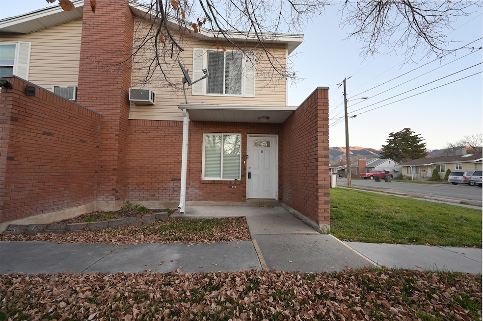
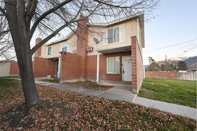
285 W 600 N Unit 1 Logan, UT 84321
Ellis NeighborhoodEstimated payment $1,549/month
Highlights
- Mountain View
- Window Unit Cooling System
- Tile Flooring
- Double Pane Windows
- Open Patio
- 4-minute walk to Jones Neighborhood Park
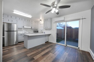
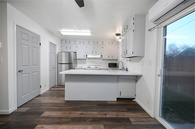
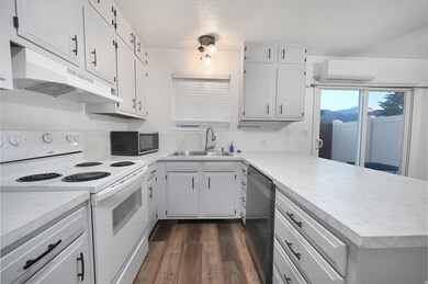
About This Home
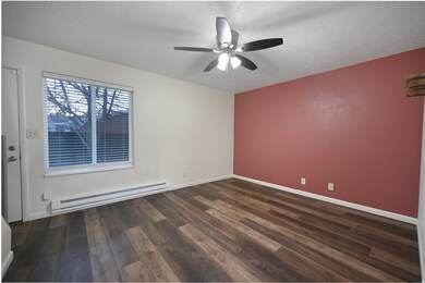
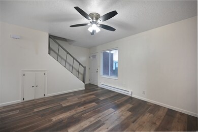
This well-kept end-unit townhome offers simple, comfortable living in a convenient Logan location. With 2 bedrooms and 1 bathroom, it's an excellent fit for a first-time buyer, student, or anyone looking to add a solid rental property to their portfolio. The brick exterior keeps maintenance low, and the private back patio gives you a quiet spot to relax or grill. Inside, the home has been cared for and shows well, with a layout that makes the most of the space. Situated near 600 N and close to USU, shopping, parks, and public transit, it's a practical choice with strong long-term value. Come take a look and see how this property can work for you.
Listing Agent
Eduardo Rodriguez
Real Broker, LLC License #12739712 Listed on: 11/28/2025
Townhouse Details
Home Type
- Townhome
Est. Annual Taxes
- $986
Year Built
- Built in 1979
Lot Details
- 1,307 Sq Ft Lot
- Property is Fully Fenced
- Sprinkler System
HOA Fees
- $125 Monthly HOA Fees
Home Design
- Brick Exterior Construction
Interior Spaces
- 954 Sq Ft Home
- 2-Story Property
- Ceiling Fan
- Double Pane Windows
- Sliding Doors
- Mountain Views
- Range Hood
- Electric Dryer Hookup
Flooring
- Carpet
- Laminate
- Tile
Bedrooms and Bathrooms
- 2 Bedrooms
Parking
- 1 Parking Space
- 1 Carport Space
Outdoor Features
- Open Patio
Schools
- Ellis Elementary School
- Mt Logan Middle School
- Logan High School
Utilities
- Window Unit Cooling System
- Heating Available
- Natural Gas Connected
- Satellite Dish
Listing and Financial Details
- Assessor Parcel Number 07-138-0003
Community Details
Overview
- Connie Seeholzer Association, Phone Number (435) 752-5154
Recreation
- Snow Removal
Pet Policy
- Pets Allowed
Map
Home Values in the Area
Average Home Value in this Area
Tax History
| Year | Tax Paid | Tax Assessment Tax Assessment Total Assessment is a certain percentage of the fair market value that is determined by local assessors to be the total taxable value of land and additions on the property. | Land | Improvement |
|---|---|---|---|---|
| 2025 | $987 | $127,650 | $0 | $0 |
| 2024 | $1,086 | $136,070 | $0 | $0 |
| 2023 | $1,165 | $139,150 | $0 | $0 |
| 2022 | $1,174 | $130,895 | $0 | $0 |
| 2021 | $940 | $161,920 | $25,000 | $136,920 |
| 2020 | $897 | $139,100 | $25,000 | $114,100 |
| 2019 | $791 | $117,379 | $25,000 | $92,379 |
| 2018 | $763 | $103,288 | $25,000 | $78,288 |
| 2017 | $691 | $49,445 | $0 | $0 |
| 2016 | $716 | $41,305 | $0 | $0 |
| 2015 | $599 | $41,305 | $0 | $0 |
| 2014 | $539 | $41,135 | $0 | $0 |
| 2013 | -- | $41,135 | $0 | $0 |
Property History
| Date | Event | Price | List to Sale | Price per Sq Ft |
|---|---|---|---|---|
| 11/28/2025 11/28/25 | For Sale | $255,000 | -- | $267 / Sq Ft |
Purchase History
| Date | Type | Sale Price | Title Company |
|---|---|---|---|
| Warranty Deed | -- | American Secure Title Logan | |
| Warranty Deed | -- | American Secure Title | |
| Warranty Deed | -- | American Secure Title Logan | |
| Interfamily Deed Transfer | -- | None Available | |
| Interfamily Deed Transfer | -- | American Secure Title | |
| Interfamily Deed Transfer | -- | American Secure Title | |
| Interfamily Deed Transfer | -- | None Available | |
| Warranty Deed | -- | American Secure Title |
Mortgage History
| Date | Status | Loan Amount | Loan Type |
|---|---|---|---|
| Open | $225,834 | FHA | |
| Closed | $13,317 | No Value Available | |
| Previous Owner | $88,271 | FHA | |
| Previous Owner | $57,750 | New Conventional | |
| Previous Owner | $60,500 | New Conventional | |
| Previous Owner | $10,097 | Stand Alone Second | |
| Previous Owner | $50,520 | New Conventional |
Source: UtahRealEstate.com
MLS Number: 2124829
APN: 07-138-0001
Disclaimer: Certain information contained herein is derived from information provided by parties other than Homes.com. All information provided is deemed reliable, but is not guaranteed to be accurate and should be independently verified.
![]() IDX information is provided exclusively for consumers’ personal, non-commercial use, that it may not be used for any purpose other than to identify prospective properties consumers may be interested in purchasing, and that the data is deemed reliable but is not guaranteed accurate by the MLS. Licensor is only providing the MLS Content and not other sources of data provided in the Product.
IDX information is provided exclusively for consumers’ personal, non-commercial use, that it may not be used for any purpose other than to identify prospective properties consumers may be interested in purchasing, and that the data is deemed reliable but is not guaranteed accurate by the MLS. Licensor is only providing the MLS Content and not other sources of data provided in the Product.
Based on information from the Wasatch Front Regional Multiple Listing Service, Inc.. All data, including all measurements and calculations of area, is obtained from various sources and has not been, and will not be, verified by broker or the MLS. All information should be independently reviewed and verified for accuracy. Properties may or may not be listed by the office/agent presenting the information.