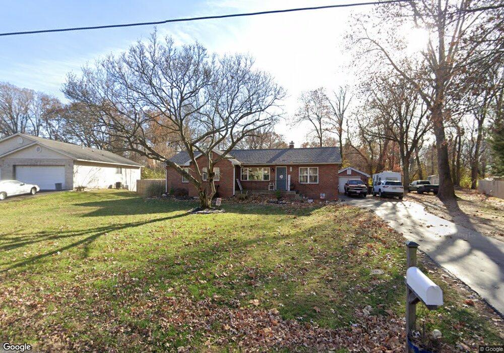
285 W Haller Dr East Alton, IL 62024
Estimated Value: $133,000 - $218,000
3
Beds
2
Baths
1,233
Sq Ft
$147/Sq Ft
Est. Value
About This Home
This home is located at 285 W Haller Dr, East Alton, IL 62024 and is currently estimated at $180,834, approximately $146 per square foot. 285 W Haller Dr is a home located in Madison County with nearby schools including Eastwood Elementary School, East Alton Middle School, and East Alton-Wood River High School.
Ownership History
Date
Name
Owned For
Owner Type
Purchase Details
Closed on
Mar 27, 2015
Sold by
Weaver Lon
Bought by
Brown Patrick O and Angleton Ryan M
Current Estimated Value
Home Financials for this Owner
Home Financials are based on the most recent Mortgage that was taken out on this home.
Original Mortgage
$48,300
Interest Rate
3.67%
Mortgage Type
Purchase Money Mortgage
Create a Home Valuation Report for This Property
The Home Valuation Report is an in-depth analysis detailing your home's value as well as a comparison with similar homes in the area
Home Values in the Area
Average Home Value in this Area
Purchase History
| Date | Buyer | Sale Price | Title Company |
|---|---|---|---|
| Brown Patrick O | $48,300 | Community Title & Escrow Ltd |
Source: Public Records
Mortgage History
| Date | Status | Borrower | Loan Amount |
|---|---|---|---|
| Closed | Brown Patrick O | $48,300 |
Source: Public Records
Tax History Compared to Growth
Tax History
| Year | Tax Paid | Tax Assessment Tax Assessment Total Assessment is a certain percentage of the fair market value that is determined by local assessors to be the total taxable value of land and additions on the property. | Land | Improvement |
|---|---|---|---|---|
| 2024 | $4,913 | $54,760 | $5,800 | $48,960 |
| 2023 | $4,913 | $51,050 | $5,410 | $45,640 |
| 2022 | $4,622 | $47,110 | $4,990 | $42,120 |
| 2021 | $4,290 | $43,910 | $4,650 | $39,260 |
| 2020 | $4,820 | $42,290 | $4,480 | $37,810 |
| 2019 | $4,774 | $41,030 | $4,350 | $36,680 |
| 2018 | $4,711 | $39,000 | $4,140 | $34,860 |
| 2017 | $4,481 | $38,070 | $4,040 | $34,030 |
| 2016 | $4,360 | $38,070 | $4,040 | $34,030 |
| 2015 | $3,513 | $37,670 | $4,000 | $33,670 |
| 2014 | $3,513 | $37,670 | $4,000 | $33,670 |
| 2013 | $3,513 | $38,220 | $4,060 | $34,160 |
Source: Public Records
Map
Nearby Homes
- 250 Hi Pointe Place
- 283 Hi Pointe Place
- 141 S 9th St
- 211 S 9th St
- 144 S 9th St
- 604 Wood River Ave
- 345 Illinois Ave
- 14 Dell Ave
- 959 Cedar Dr
- 523 Lincoln Ave
- 104 Whitelaw Ave
- 121 Whitelaw Ave
- 225 Lakeside Ave
- 98 Wood River Ave
- 523 Wilson Ave
- 420 Bowman Ave
- 133 Lincoln Ave
- 523 Broadway
- 417 California Ave
- 833 State St
- 281 W Haller Dr
- 289 W Haller Dr
- 279 W Haller Dr
- 292 W Haller Dr
- 288 W Haller Dr
- 293 W Haller Dr
- 276 W Haller Dr
- 275 W Haller Dr
- 258 Westwood Place
- 264 Westwood Place
- 252 Westwood Place
- 270 Westwood Place
- 297 W Haller Dr
- 264 W Haller Dr
- 285 W Airline Dr
- 263 W Haller Dr
- 277 W Airline Dr
- 296 W Haller Dr
- 246 Westwood Place
- 295 W Haller Dr