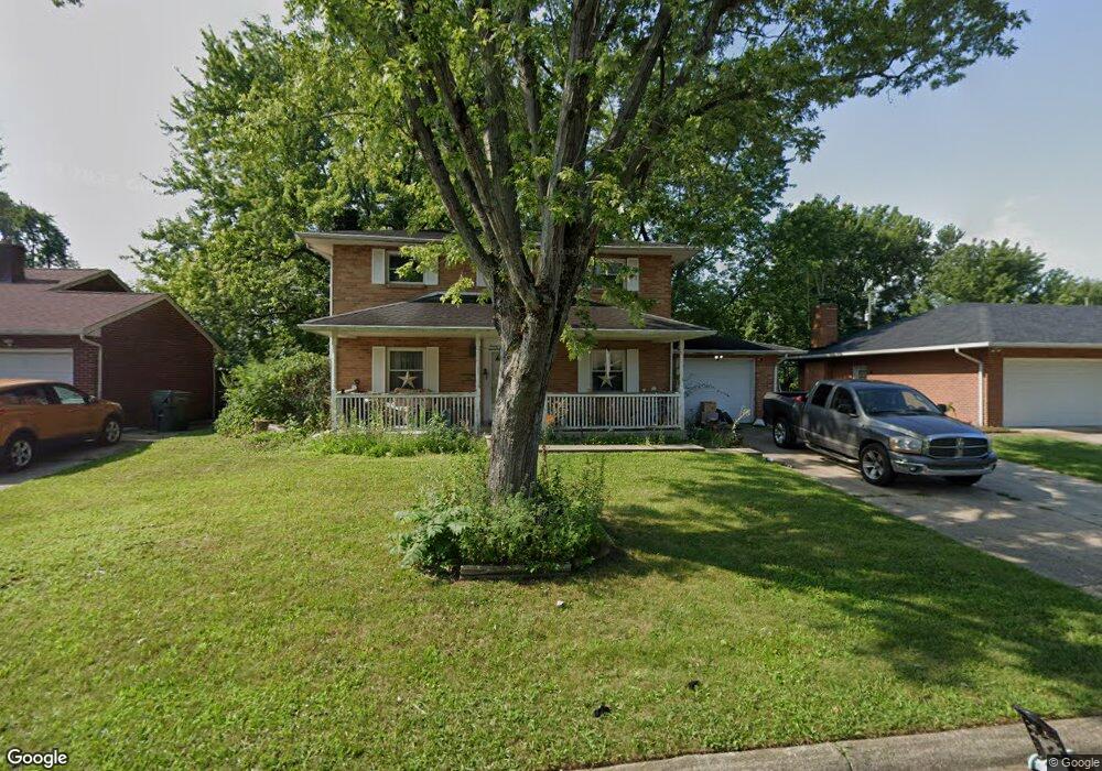
2859 Nicholas Ave Columbus, OH 43204
Brookshire NeighborhoodEstimated Value: $226,000 - $289,000
4
Beds
2
Baths
1,600
Sq Ft
$166/Sq Ft
Est. Value
About This Home
This home is located at 2859 Nicholas Ave, Columbus, OH 43204 and is currently estimated at $266,212, approximately $166 per square foot. 2859 Nicholas Ave is a home located in Franklin County with nearby schools including Binns Elementary School, Wedgewood Middle School, and Briggs High School.
Ownership History
Date
Name
Owned For
Owner Type
Purchase Details
Closed on
May 5, 1995
Sold by
Benson Rose A
Bought by
Lois A Hord
Current Estimated Value
Home Financials for this Owner
Home Financials are based on the most recent Mortgage that was taken out on this home.
Original Mortgage
$83,078
Interest Rate
8.43%
Mortgage Type
FHA
Purchase Details
Closed on
Aug 1, 1986
Purchase Details
Closed on
Jun 1, 1979
Create a Home Valuation Report for This Property
The Home Valuation Report is an in-depth analysis detailing your home's value as well as a comparison with similar homes in the area
Home Values in the Area
Average Home Value in this Area
Purchase History
| Date | Buyer | Sale Price | Title Company |
|---|---|---|---|
| Lois A Hord | $85,000 | -- | |
| -- | $66,500 | -- | |
| -- | $50,000 | -- |
Source: Public Records
Mortgage History
| Date | Status | Borrower | Loan Amount |
|---|---|---|---|
| Closed | Lois A Hord | $83,078 |
Source: Public Records
Tax History Compared to Growth
Tax History
| Year | Tax Paid | Tax Assessment Tax Assessment Total Assessment is a certain percentage of the fair market value that is determined by local assessors to be the total taxable value of land and additions on the property. | Land | Improvement |
|---|---|---|---|---|
| 2024 | $4,127 | $91,950 | $16,100 | $75,850 |
| 2023 | $4,074 | $91,945 | $16,100 | $75,845 |
| 2022 | $2,776 | $53,520 | $7,700 | $45,820 |
| 2021 | $2,781 | $53,520 | $7,700 | $45,820 |
| 2020 | $2,784 | $53,520 | $7,700 | $45,820 |
| 2019 | $2,771 | $45,680 | $6,690 | $38,990 |
| 2018 | $2,445 | $45,680 | $6,690 | $38,990 |
| 2017 | $2,769 | $45,680 | $6,690 | $38,990 |
| 2016 | $2,340 | $35,320 | $6,090 | $29,230 |
| 2015 | $2,124 | $35,320 | $6,090 | $29,230 |
| 2014 | $2,129 | $35,320 | $6,090 | $29,230 |
| 2013 | $1,235 | $41,545 | $7,175 | $34,370 |
Source: Public Records
Map
Nearby Homes
- 2856 Chesfield Dr
- 2987 Daisy Ln
- 1520 Fall Brook Rd
- 1248 Gresham Rd
- 2929 Briggs Rd
- 1465 Tall Meadows Dr
- 2743 Saint Joseph Ave
- 1037 Chestershire Rd
- 2547 Rosedale Ave
- 1181 Onslow Dr
- 2800 Alkire Rd
- 2610 Spaatz Ave
- 0 Glencreek Rd
- 3029 Rosedale Ave
- 3326 Bluhm Ct
- 0 S Central Ave
- 903 S Harris Ave
- 2894 Creith Ct
- 2743 Bernadette Rd
- 898 Chestershire Rd
- 2867 Nicholas Ave
- 2851 Nicholas Ave
- 2879 Nicholas Ave
- 2843 Nicholas Ave
- 2856 Nicholas Ave
- 2864 Nicholas Ave
- 2848 Nicholas Ave
- 2876 Nicholas Ave
- 2835 Nicholas Ave
- 1400 Bellflower Ave
- 2888 Nicholas Ave
- 2840 Nicholas Ave
- 1414 Bellflower Ave
- 2827 Nicholas Ave
- 2849 Briggston Ave
- 2857 Briggston Ave
- 2832 Nicholas Ave
- 1372 Bellflower Ave
- 2841 Briggston Ave
- 2865 Briggston Ave