Estimated Value: $127,780 - $230,000
3
Beds
2
Baths
1,305
Sq Ft
$143/Sq Ft
Est. Value
About This Home
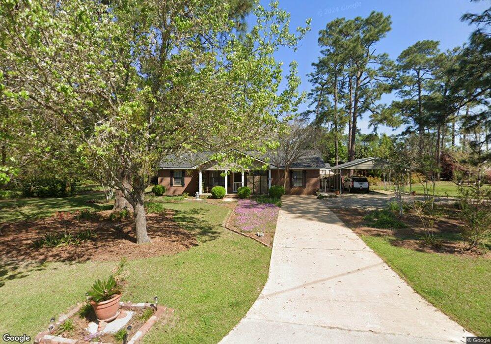
This home is located at 2859 Slash Ave NE, Cairo, GA 39828 and is currently estimated at $187,195, approximately $143 per square foot. 2859 Slash Ave NE is a home located in Grady County with nearby schools including Cairo High School.
Ownership History
Date
Name
Owned For
Owner Type
Purchase Details
Closed on
Jul 9, 2024
Sold by
Mccullough Kathy
Bought by
Mccullough Robert G and Mccullough Robert
Current Estimated Value
Purchase Details
Closed on
Mar 27, 2014
Sold by
Chastain Kevin
Bought by
Mccullough Robert G
Purchase Details
Closed on
May 22, 1992
Bought by
Chastain Kevin
Create a Home Valuation Report for This Property
The Home Valuation Report is an in-depth analysis detailing your home's value as well as a comparison with similar homes in the area
Home Values in the Area
Average Home Value in this Area
Purchase History
| Date | Buyer | Sale Price | Title Company |
|---|---|---|---|
| Mccullough Robert G | -- | -- | |
| Mccullough Robert G | $110,000 | -- | |
| Chastain Kevin | $48,500 | -- |
Source: Public Records
Tax History Compared to Growth
Tax History
| Year | Tax Paid | Tax Assessment Tax Assessment Total Assessment is a certain percentage of the fair market value that is determined by local assessors to be the total taxable value of land and additions on the property. | Land | Improvement |
|---|---|---|---|---|
| 2024 | $1,815 | $46,010 | $4,180 | $41,830 |
| 2023 | $1,353 | $36,542 | $6,059 | $30,483 |
| 2022 | $1,407 | $36,542 | $6,059 | $30,483 |
| 2021 | $1,411 | $36,542 | $6,059 | $30,483 |
| 2020 | $1,415 | $36,542 | $6,059 | $30,483 |
| 2019 | $1,414 | $36,542 | $6,059 | $30,483 |
| 2018 | $1,344 | $36,542 | $6,059 | $30,483 |
| 2017 | $1,293 | $36,542 | $6,059 | $30,483 |
| 2016 | $1,131 | $31,262 | $6,059 | $25,203 |
| 2015 | $1,120 | $31,262 | $6,059 | $25,203 |
| 2014 | $1,065 | $31,262 | $6,059 | $25,203 |
| 2013 | -- | $28,234 | $6,058 | $22,176 |
Source: Public Records
Map
Nearby Homes
- 0 NE Airport Rd Unit 145784
- 78.6 Ac Strickland Rd
- 2600 U S 84
- 66 22nd St NE
- 21 24th St NE
- 3109 U S 84
- 3109 U S 84
- 0 20th St NE
- 00 20th St NE
- 00 #10 Oak Bend Circle 4 38 Acres
- 00 State Route 188
- 0 State Route 188
- 00 NW 9th Ave
- 711 2nd Ave NE
- 236 Helton Ln
- 225 Helton Ln
- Lot #15, 3 64 Acres Oakbend Cir
- 530 6th Ave SE
- 471 4th St SE
- 530 6th St
- 675 Airport Rd
- 2990 Horry Ave
- 385 Airport Rd
- 402 Airport Rd
- 690 Airport Rd
- 2880 Slash Ave NE
- 375 Airport Rd
- 2851 Slash Ave NE
- 2850 Horry Ave
- 420 Airport Rd
- 2885 Horry Ave
- 701 Airport Rd
- 2848 Slash Ave NE
- 700 Airport Rd
- 2849 Slash Ave NE
- 2840 Horry Ave
- 2855 Horry Ave
- 0000 Palmer Ave
- 188 Palmer Ave
- 404 Airport Rd