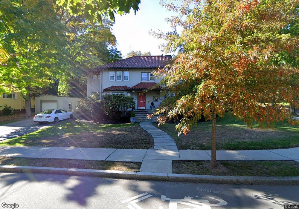
286 Clark Rd Brookline, MA 02445
Brookline Village NeighborhoodEstimated Value: $2,201,000 - $2,519,000
4
Beds
3
Baths
2,227
Sq Ft
$1,087/Sq Ft
Est. Value
About This Home
This home is located at 286 Clark Rd, Brookline, MA 02445 and is currently estimated at $2,420,801, approximately $1,087 per square foot. 286 Clark Rd is a home located in Norfolk County with nearby schools including John D. Runkle School, Brookline High School, and Torah Academy.
Ownership History
Date
Name
Owned For
Owner Type
Purchase Details
Closed on
Jan 10, 2013
Sold by
Frank Daniel and Frank Norma A
Bought by
286 Clark Street Rt
Current Estimated Value
Purchase Details
Closed on
May 6, 1986
Bought by
Frank Daniel and Frank Norma A
Create a Home Valuation Report for This Property
The Home Valuation Report is an in-depth analysis detailing your home's value as well as a comparison with similar homes in the area
Home Values in the Area
Average Home Value in this Area
Purchase History
| Date | Buyer | Sale Price | Title Company |
|---|---|---|---|
| 286 Clark Street Rt | -- | -- | |
| Frank Daniel | $390,000 | -- |
Source: Public Records
Mortgage History
| Date | Status | Borrower | Loan Amount |
|---|---|---|---|
| Previous Owner | Frank Daniel | $200,000 |
Source: Public Records
Tax History
| Year | Tax Paid | Tax Assessment Tax Assessment Total Assessment is a certain percentage of the fair market value that is determined by local assessors to be the total taxable value of land and additions on the property. | Land | Improvement |
|---|---|---|---|---|
| 2025 | $21,951 | $2,224,000 | $1,398,200 | $825,800 |
| 2024 | $20,904 | $2,139,600 | $1,344,400 | $795,200 |
| 2023 | $17,354 | $1,740,600 | $960,500 | $780,100 |
| 2022 | $16,892 | $1,657,700 | $914,700 | $743,000 |
| 2021 | $15,620 | $1,593,900 | $879,500 | $714,400 |
| 2020 | $14,215 | $1,504,200 | $799,600 | $704,600 |
| 2019 | $13,423 | $1,432,500 | $761,500 | $671,000 |
| 2018 | $13,518 | $1,429,000 | $766,100 | $662,900 |
| 2017 | $13,319 | $1,348,100 | $722,800 | $625,300 |
| 2016 | $13,128 | $1,259,900 | $675,500 | $584,400 |
| 2015 | $12,576 | $1,177,500 | $631,300 | $546,200 |
| 2014 | $12,520 | $1,099,200 | $573,900 | $525,300 |
Source: Public Records
Map
Nearby Homes
- 135 Beaconsfield Rd Unit 2
- 34 Hyslop Rd
- 43 Druce St
- 282 Buckminster Rd
- 20 Claflin Rd Unit A
- 120 Seaver St Unit C-102
- 90 Addington Rd Unit 1
- 90 Addington Rd Unit 2
- 1778 Beacon St Unit 302
- 195 Winthrop Rd Unit 1
- 57 University Rd Unit 3
- 15 Colbourne Crescent Unit 2
- 4 7 Englewood Ave
- 55 Leicester St
- 22 Windsor Rd
- 24 Blake Rd
- 101 Winthrop Rd Unit 1
- 89 University Rd
- 84 Winthrop Rd Unit 1
- 84 Winthrop Rd
- 280 Clark Rd
- 285 Clark Rd
- 295 Clark Rd
- 279 Clark Rd
- 54 Cotswold Rd
- 301 Clark Rd
- 147 Clinton Rd
- 46 Cotswold Rd
- 270 Clark Rd
- 305 Clark Rd
- 137 Clinton Rd
- 269 Clark Rd
- 308 Clark Rd
- 266 Clark Rd
- 161 Clinton Rd
- 70 Beaconsfield Rd Unit 72
- 62 Beaconsfield Rd
- 72 Beaconsfield Rd
- 72 Beaconsfield Rd Unit B
- 72 Beaconsfield Rd Unit 2
Your Personal Tour Guide
Ask me questions while you tour the home.