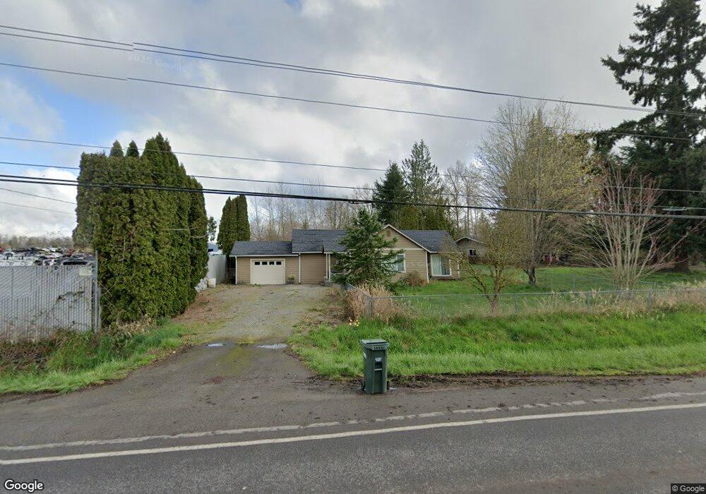
28607 112th St E Buckley, WA 98321
Estimated Value: $434,000 - $476,000
3
Beds
1
Bath
1,126
Sq Ft
$406/Sq Ft
Est. Value
About This Home
This home is located at 28607 112th St E, Buckley, WA 98321 and is currently estimated at $456,835, approximately $405 per square foot. 28607 112th St E is a home located in Pierce County with nearby schools including Elk Ridge Elementary School and Glacier Middle School.
Ownership History
Date
Name
Owned For
Owner Type
Purchase Details
Closed on
Dec 8, 2020
Sold by
Dirth Matthew Phillip and Dirth Sheila T
Bought by
Barnes Jeffrey
Current Estimated Value
Home Financials for this Owner
Home Financials are based on the most recent Mortgage that was taken out on this home.
Original Mortgage
$351,140
Outstanding Balance
$313,177
Interest Rate
2.8%
Mortgage Type
New Conventional
Estimated Equity
$143,658
Purchase Details
Closed on
Jul 14, 2014
Sold by
Williams Michael D and Williams Tracy L
Bought by
Dirth Matthew Phillip
Home Financials for this Owner
Home Financials are based on the most recent Mortgage that was taken out on this home.
Original Mortgage
$213,265
Interest Rate
4.11%
Mortgage Type
New Conventional
Purchase Details
Closed on
Feb 12, 2014
Sold by
Durgin Karen
Bought by
Williams Michael D
Purchase Details
Closed on
Aug 14, 2012
Sold by
Durgin Karen
Bought by
Durgin Karen
Create a Home Valuation Report for This Property
The Home Valuation Report is an in-depth analysis detailing your home's value as well as a comparison with similar homes in the area
Home Values in the Area
Average Home Value in this Area
Purchase History
| Date | Buyer | Sale Price | Title Company |
|---|---|---|---|
| Barnes Jeffrey | $362,000 | First American Title Company | |
| Dirth Matthew Phillip | $208,719 | Old Republic Title Ltd | |
| Williams Michael D | $26,719 | Fatco | |
| Durgin Karen | -- | None Available |
Source: Public Records
Mortgage History
| Date | Status | Borrower | Loan Amount |
|---|---|---|---|
| Open | Barnes Jeffrey | $351,140 | |
| Previous Owner | Dirth Matthew Phillip | $213,265 |
Source: Public Records
Tax History
| Year | Tax Paid | Tax Assessment Tax Assessment Total Assessment is a certain percentage of the fair market value that is determined by local assessors to be the total taxable value of land and additions on the property. | Land | Improvement |
|---|---|---|---|---|
| 2025 | $3,456 | $415,000 | $213,700 | $201,300 |
| 2024 | $3,456 | $397,200 | $206,000 | $191,200 |
| 2023 | $3,456 | $377,400 | $200,100 | $177,300 |
| 2022 | $3,520 | $401,400 | $221,500 | $179,900 |
| 2021 | $3,367 | $288,600 | $136,800 | $151,800 |
| 2019 | $2,810 | $264,000 | $113,400 | $150,600 |
| 2018 | $2,937 | $244,700 | $100,100 | $144,600 |
| 2017 | $2,591 | $222,100 | $84,100 | $138,000 |
| 2016 | $2,270 | $98,700 | $60,200 | $38,500 |
| 2014 | $2,192 | $142,700 | $50,400 | $92,300 |
| 2013 | $2,192 | $135,100 | $48,200 | $86,900 |
Source: Public Records
Map
Nearby Homes
- 0 Mundy Loss Rd E Unit NWM2437837
- 27805 Hinkleman Rd
- 133 S Naches St
- 27716 Entwhistle Rd E
- 437 Main St
- 950 York St
- 326 Perkins St
- 433 Hatch St
- 788 Holly Ave Unit 42
- 808 Britschgi St Unit 43
- 269 S Cedar St
- 867 Smith St Unit 29
- 517 Dundass Ave
- 730 Holly Ave
- 435 Hatch St
- 27515 Entwhistle Rd E
- 967 Smith St Unit 22
- 912 Smith St Unit 64
- 918 Smith St Unit 63
- 713 Madden Ave Unit 19
- 28609 112th St E
- 0 XXX65 112th St E
- 24521 112th St E
- 28618 112th St E
- 28706 112th St E
- 28721 112th St E
- 28505 112th St E
- 28807 112th St E
- 12243 Mundy Loss Rd E
- 308 N Foster St
- 28718 State Route 410 E
- 28818 112th St E
- 28417 112th St E
- 28820 State Route 410 E
- 0 Sr 410 Unit 29070231
- 28421 112th St E
- 28808 Hwy 410
- 28593 State Route 410 E
- 28301 112th St E
Your Personal Tour Guide
Ask me questions while you tour the home.