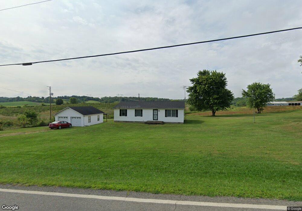
28655 State Route 124 Langsville, OH 45741
Estimated Value: $109,000 - $222,000
3
Beds
1
Bath
1,196
Sq Ft
$135/Sq Ft
Est. Value
About This Home
This home is located at 28655 State Route 124, Langsville, OH 45741 and is currently estimated at $161,849, approximately $135 per square foot. 28655 State Route 124 is a home located in Meigs County with nearby schools including Meigs Primary School, Meigs Intermediate School, and Meigs Middle School.
Ownership History
Date
Name
Owned For
Owner Type
Purchase Details
Closed on
Oct 11, 2019
Sold by
Crisp M Charlayne
Bought by
Crisp M Charlayne
Current Estimated Value
Purchase Details
Closed on
May 25, 1993
Bought by
Crisp M Charlayne
Create a Home Valuation Report for This Property
The Home Valuation Report is an in-depth analysis detailing your home's value as well as a comparison with similar homes in the area
Home Values in the Area
Average Home Value in this Area
Purchase History
| Date | Buyer | Sale Price | Title Company |
|---|---|---|---|
| Crisp M Charlayne | -- | None Available | |
| Crisp M Charlayne | -- | -- |
Source: Public Records
Tax History Compared to Growth
Tax History
| Year | Tax Paid | Tax Assessment Tax Assessment Total Assessment is a certain percentage of the fair market value that is determined by local assessors to be the total taxable value of land and additions on the property. | Land | Improvement |
|---|---|---|---|---|
| 2024 | $1,131 | $34,510 | $4,540 | $29,970 |
| 2023 | $1,131 | $34,510 | $4,540 | $29,970 |
| 2022 | $1,190 | $34,510 | $4,540 | $29,970 |
| 2021 | $1,043 | $25,640 | $2,900 | $22,740 |
| 2020 | $970 | $25,640 | $2,900 | $22,740 |
| 2019 | $957 | $25,640 | $2,900 | $22,740 |
| 2018 | $842 | $22,760 | $640 | $22,120 |
| 2017 | $842 | $22,760 | $640 | $22,120 |
| 2016 | $834 | $22,760 | $640 | $22,120 |
| 2014 | $619 | $18,890 | $640 | $18,250 |
| 2013 | $619 | $18,890 | $640 | $18,250 |
Source: Public Records
Map
Nearby Homes
- 28600 Ohio 124
- 28033 State Route 124
- 0 Red Hill Rd Unit 22347212
- 0 Edmundson Rd Unit Tract 1 Phase 2 Big
- 0 Edmundson Rd Unit 23607169
- 0 Edmundson Rd Unit (Tract 2 at Big Timb
- 0 Edmundson Rd Unit 23597084
- 0 Edmundson Rd Unit 23463048
- 0 Edmundson Rd Unit (Tract 5 at Big Timb
- 0 Edmundson Rd Unit (Tract 6 at Big Timb
- 0 Edmundson Rd Unit 2429533
- 31845 Red Hill Rd
- 32319 Red Hill Rd Unit (Overlook Cabin at B
- 31152 Edmundson Rd
- 3229 Painter Ridge Rd
- 0 Star Hall Rd
- 0 Briar Ridge Rd Unit 11566708
- 0 Briar Ridge Rd Unit 24580053
- 0 Briar Ridge Rd Unit 24580050
- 30286 Briar Ridge Rd
- 28655 State Route 124
- 28650 State Route 124
- 28704 State Route 124
- 32914 Salem School Lot Rd
- 28507 State Route 124
- 0 Salem School Unit RD 222035801
- 28924 State Route 124
- 32415 Red Hill Rd
- 32485 Painter Ridge Rd
- 32477 Painter Ridge Rd
- 32325 Red Hill Rd Unit (Phase I Tract 1A Bi
- 0 Red Hill Rd Unit (7 Acres at Big Timb
- 0 Red Hill Rd Unit (10 Acres at Big Tim
- 0 Red Hill Rd Unit (15 Acres at Big Tim
- 0 Red Hill Rd
- 32411 Painter Ridge Rd
- 32377 Painter Ridge Rd
- 32327 Painter Ridge Rd
- 32311 Painter Ridge Rd
- 0 Edmundson Rd Unit 2430799