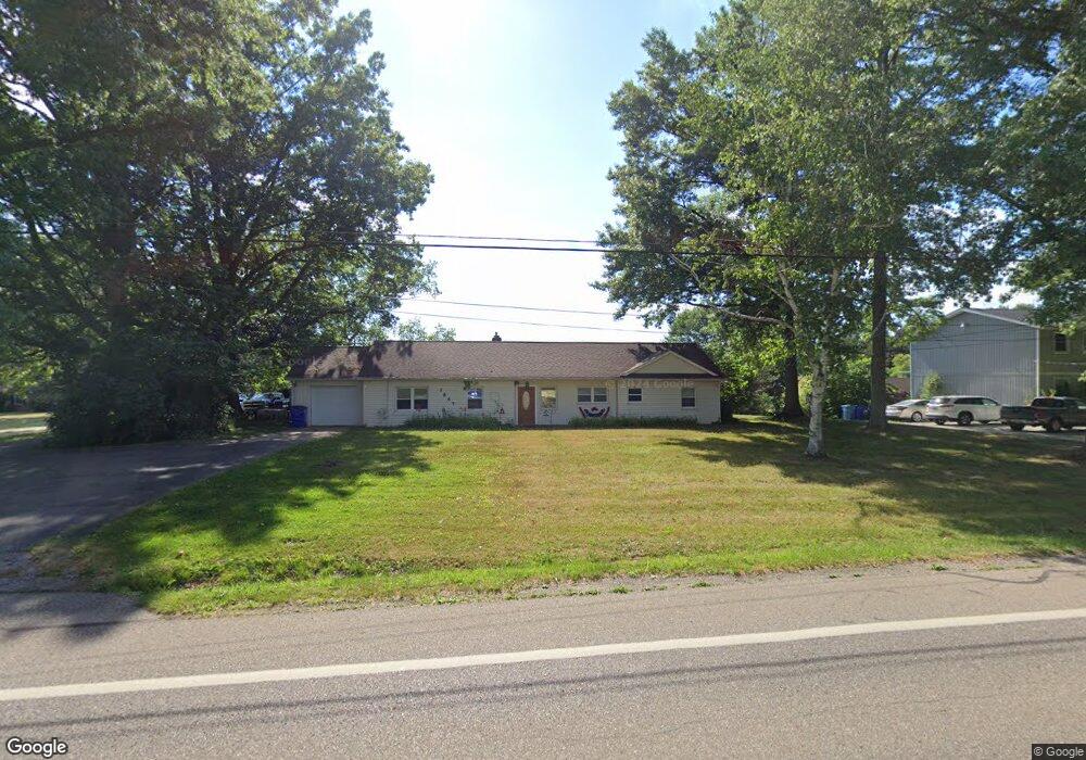
2867 State Route 43 Mogadore, OH 44260
Estimated Value: $253,000 - $317,000
3
Beds
3
Baths
2,205
Sq Ft
$130/Sq Ft
Est. Value
About This Home
This home is located at 2867 State Route 43, Mogadore, OH 44260 and is currently estimated at $286,059, approximately $129 per square foot. 2867 State Route 43 is a home located in Portage County with nearby schools including Suffield Elementary School, Field Middle School, and Field High School.
Ownership History
Date
Name
Owned For
Owner Type
Purchase Details
Closed on
Apr 9, 2008
Sold by
Mccarron Judith B
Bought by
Mccallister Michael D and Uhlenhake Sara
Current Estimated Value
Home Financials for this Owner
Home Financials are based on the most recent Mortgage that was taken out on this home.
Original Mortgage
$124,019
Outstanding Balance
$79,051
Interest Rate
6.09%
Mortgage Type
FHA
Estimated Equity
$207,008
Purchase Details
Closed on
Nov 5, 2004
Sold by
Mccarron James W
Bought by
Mccarron Judith B
Purchase Details
Closed on
May 6, 1985
Bought by
Mccarron James W
Create a Home Valuation Report for This Property
The Home Valuation Report is an in-depth analysis detailing your home's value as well as a comparison with similar homes in the area
Home Values in the Area
Average Home Value in this Area
Purchase History
| Date | Buyer | Sale Price | Title Company |
|---|---|---|---|
| Mccallister Michael D | $125,000 | Portage Title Agency | |
| Mccarron Judith B | -- | -- | |
| Mccarron James W | $69,900 | -- |
Source: Public Records
Mortgage History
| Date | Status | Borrower | Loan Amount |
|---|---|---|---|
| Open | Mccallister Michael D | $124,019 |
Source: Public Records
Tax History Compared to Growth
Tax History
| Year | Tax Paid | Tax Assessment Tax Assessment Total Assessment is a certain percentage of the fair market value that is determined by local assessors to be the total taxable value of land and additions on the property. | Land | Improvement |
|---|---|---|---|---|
| 2024 | $3,358 | $70,280 | $14,770 | $55,510 |
| 2023 | $3,500 | $59,080 | $9,240 | $49,840 |
| 2021 | $3,421 | $59,080 | $9,240 | $49,840 |
| 2020 | $2,981 | $46,450 | $9,240 | $37,210 |
| 2019 | $2,942 | $46,450 | $9,240 | $37,210 |
| 2018 | $1,842 | $34,370 | $9,240 | $25,130 |
| 2017 | $1,842 | $34,370 | $9,240 | $25,130 |
| 2016 | $1,836 | $34,370 | $9,240 | $25,130 |
| 2015 | $1,777 | $34,370 | $9,240 | $25,130 |
| 2014 | $1,714 | $34,370 | $9,240 | $25,130 |
| 2013 | $1,675 | $34,370 | $9,240 | $25,130 |
Source: Public Records
Map
Nearby Homes
- 3241 State Route 43
- 1489 Old Forge Rd
- 3434 Lawndale Dr
- 1330 Highpoint St
- 3517 Jameson Dr
- 1707 Old Forge Rd
- 2835 Sunnybrook Rd
- 596 Ticknor Rd
- 1811 Randolph Rd
- 3362 Sunnybrook Rd
- 3658 Elmhurst Ct
- 1418 Arcadia Rd
- 3579 Elmhurst Ct
- 3672 Elmhurst Ct
- 0 Randolph Rd Unit 5112744
- 1125 Dussel Rd
- 2662 Martin Rd
- 1088 Irish Rd
- 3793 Ranfield Rd
- 3946 Mctaggart Blvd
- 2877 State Route 43
- 2878 State Route 43
- 2854 State Route 43
- 2859 State Route 43
- 1270 Squires Dr
- 2848 State Route 43
- 1250 Squires Dr
- 2824 State Route 43
- 1263 Squires Dr
- 2810 State Route 43
- 1234 Squires Dr
- 2811 State Route 43
- 1247 Squires Dr
- 1220 Squires Dr
- 1233 Saxe Rd
- 2947 State Route 43
- 1223 Squires Dr
- 1204 Squires Dr
- 2788 State Route 43
- 1209 Saxe Rd