287 Mustang Trail Fairplay, CO 80432
Estimated payment $234/month
Highlights
- View of Trees or Woods
- Southern Exposure
- Satellite Dish
About This Lot
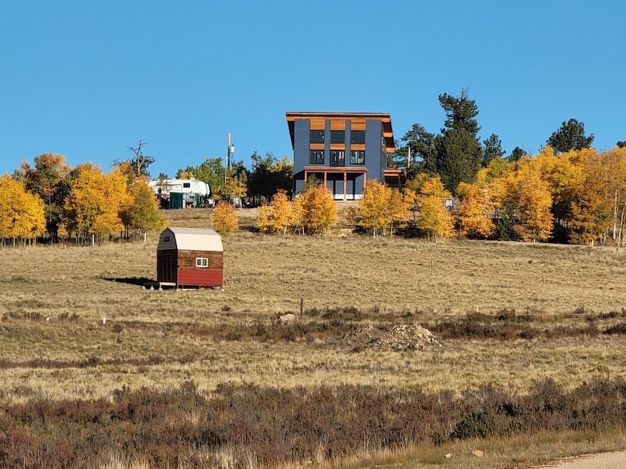
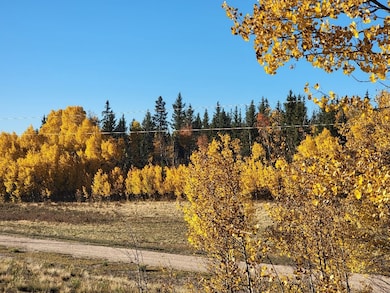
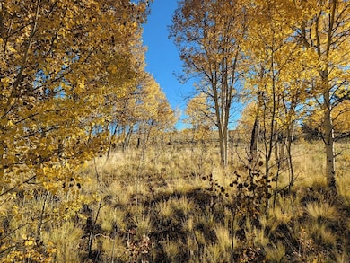
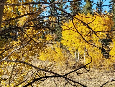
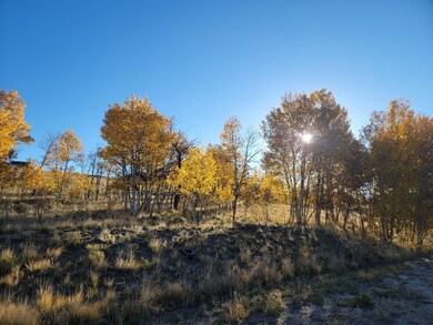
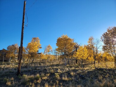
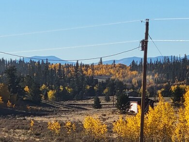
Beautiful Lot in Indian Mountain Subdivision which lies off Hwy 285 between Jefferson and Fairplay. Just a couple of Aspen Trees, see Fall pictures, with surrounding mountainous views and shed located upon this South facing 1 acre parcel. Plenty of solar exposure to aide in drying up the ice and snow. Only appro 19 miles to Fairplay, where you can stroll on Front Street, to many mountain shops, restaurants, and South Park City, an amazing museum that takes you back in time...National Forest all around, go to South Park Ranger Station store on Hwy9 and Hwy 285 to get map of many hiking, biking trails. Fishing in many spots as well, so grab your fishing pole and enjoy! Another 18 miles from Fairplay to Breckenridge where you can go skiing, shopping, events and restaurants. Or if its adventure you are looking for, go South on Hwy 285 to Buena Vista, Rock Climbing, Water rafting or go to secluded hot springs and relax. Approx (153 miles) 2 hours to Denver Airport for travel by air. A nice neighborhood awaits, bordered by a home to its East side and one across the Street, Located in Indian Mountain Subdivision, has easy access, year round maintained roads, and has electricity at frontage road of property. Walk this lot and it will not disappoint.The Indian Mountain community offers amenities for residents such as a clubhouse, BBQ' spot, public showers, an RV dump site. Many National forest trails in area as well as World Class fishing.
Property Details
Property Type
- Land
Est. Annual Taxes
- $270
Lot Details
- 1 Acre Lot
- Dirt Road
- Southern Exposure
- Zoning described as Residential Rural
Property Views
- Woods
- Mountain
- Meadow
Utilities
- Propane
- Well
- Septic Needed
- Phone Available
- Satellite Dish
Community Details
- Property has a Home Owners Association
- Indian Mountain Subdivision
Listing and Financial Details
- Assessor Parcel Number 3166
Map
Home Values in the Area
Average Home Value in this Area
Tax History
| Year | Tax Paid | Tax Assessment Tax Assessment Total Assessment is a certain percentage of the fair market value that is determined by local assessors to be the total taxable value of land and additions on the property. | Land | Improvement |
|---|---|---|---|---|
| 2024 | $270 | $4,230 | $4,230 | $0 |
| 2023 | $270 | $4,393 | $4,393 | $0 |
| 2022 | $150 | $2,092 | $2,092 | $0 |
| 2021 | $148 | $2,092 | $2,092 | $0 |
| 2020 | $143 | $1,970 | $1,970 | $0 |
| 2019 | $139 | $1,970 | $1,970 | $0 |
| 2018 | $142 | $1,970 | $1,970 | $0 |
| 2017 | $145 | $1,970 | $1,970 | $0 |
| 2016 | $145 | $2,270 | $2,270 | $0 |
| 2015 | $147 | $2,270 | $2,270 | $0 |
| 2014 | $105 | $0 | $0 | $0 |
Property History
| Date | Event | Price | List to Sale | Price per Sq Ft |
|---|---|---|---|---|
| 11/12/2025 11/12/25 | For Sale | $40,000 | -- | -- |
Purchase History
| Date | Type | Sale Price | Title Company |
|---|---|---|---|
| Quit Claim Deed | $5,000 | None Available | |
| Quit Claim Deed | $5,000 | None Available | |
| Quit Claim Deed | $9,000 | None Available | |
| Quit Claim Deed | $9,000 | None Available |
Source: Summit MLS
MLS Number: S1064286
APN: 3166
Disclaimer: Certain information contained herein is derived from information provided by parties other than Homes.com. All information provided is deemed reliable, but is not guaranteed to be accurate and should be independently verified.
![]() Copyright © 2025 SAR MLS. The information displayed herein was derived from sources believed to be accurate, but has not been verified by SAR MLS. Buyers are cautioned to verify all information to their own satisfaction. This information is exclusively for viewers’ personal, non-commercial use. Any republication or reproduction of the information herein without the express permission of the SAR MLS is strictly prohibited.
Copyright © 2025 SAR MLS. The information displayed herein was derived from sources believed to be accurate, but has not been verified by SAR MLS. Buyers are cautioned to verify all information to their own satisfaction. This information is exclusively for viewers’ personal, non-commercial use. Any republication or reproduction of the information herein without the express permission of the SAR MLS is strictly prohibited.
- 1210 Kiowa St
- 000 Kiowa St
- 702 Pinto Trail
- 50 Rawhide Way Unit 28
- 1540 Warrior Cir
- 0 Hawk Way
- 82 Ignacio Way
- 83 Pelican Place
- 83 Pelican Place Unit 78
- 654 Piaute Way
- 654 Piute Way
- 47 Piaute Way
- 64 Carbine Rd
- 1140 Ute Trail
- 1059 Piute Way
- 74 Noxibee Ct
- 28 Idaho Ct
- 499 Kiowa St
- 0 Kiowa St Unit S1044835
- 138 Teton Way
- 278 Way Station Ct
- 36 Star Rock
- 613 Main St
- 4603 Co Rd 1 Unit 2 Bedroom 1 Bathroom
- 4603 Co Rd 1 Unit 2 BR, 1 BA
- 1772 County Road 4
- 0092 Scr 855
- 189 Co Rd 535
- 1 S Face Dr
- 186 Bunny Rd
- 348 Locals Ln Unit Peak 7
- 1396 Forest Hills Dr Unit ID1301396P
- 464 Silver Cir
- 3156 Nova Rd Unit ID1338725P
- 50 Drift Rd
- 11760 Baca Rd
- 501 Teller St Unit G
- 10221 Blue Sky Trail
