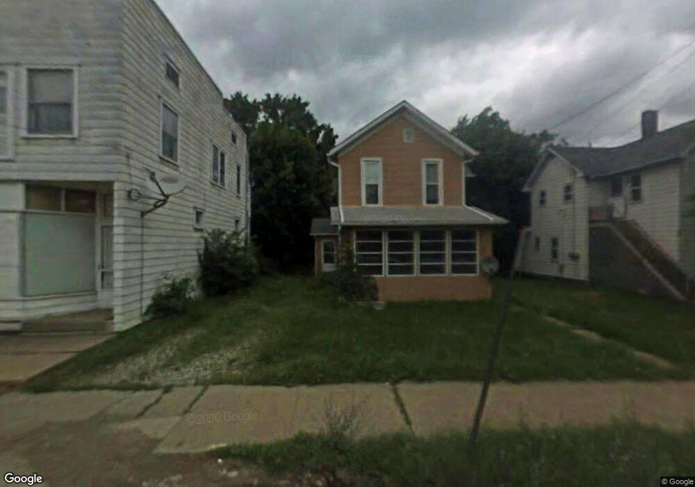
287 W Main St Alliance, OH 44601
Estimated Value: $68,000 - $123,000
4
Beds
2
Baths
1,860
Sq Ft
$51/Sq Ft
Est. Value
About This Home
This home is located at 287 W Main St, Alliance, OH 44601 and is currently estimated at $94,022, approximately $50 per square foot. 287 W Main St is a home located in Stark County with nearby schools including Alliance Early Learning School, Alliance Intermediate School at Northside, and Alliance Middle School.
Ownership History
Date
Name
Owned For
Owner Type
Purchase Details
Closed on
Apr 21, 2004
Sold by
Deutsche Bank National Trust Co
Bought by
Hurford Kenneth S and Hurford Michelle H
Current Estimated Value
Purchase Details
Closed on
Dec 24, 2003
Sold by
Shepherd George M
Bought by
Bankers Trust Co Of California Na and Impac Secured Assets Corp
Purchase Details
Closed on
Oct 20, 2000
Sold by
Warren Phillips and Warren Higgins
Bought by
Shepherd George M
Home Financials for this Owner
Home Financials are based on the most recent Mortgage that was taken out on this home.
Original Mortgage
$47,250
Interest Rate
7.87%
Mortgage Type
Purchase Money Mortgage
Purchase Details
Closed on
May 17, 1999
Sold by
Mathes Allen
Bought by
Higgins Warren R and Phillips David W
Home Financials for this Owner
Home Financials are based on the most recent Mortgage that was taken out on this home.
Original Mortgage
$20,800
Interest Rate
6.99%
Mortgage Type
Purchase Money Mortgage
Purchase Details
Closed on
Oct 29, 1996
Sold by
Syme Gerald R
Bought by
Brown George D
Create a Home Valuation Report for This Property
The Home Valuation Report is an in-depth analysis detailing your home's value as well as a comparison with similar homes in the area
Home Values in the Area
Average Home Value in this Area
Purchase History
| Date | Buyer | Sale Price | Title Company |
|---|---|---|---|
| Hurford Kenneth S | $11,000 | Chicago Title Ins Co | |
| Bankers Trust Co Of California Na | $35,000 | -- | |
| Shepherd George M | $63,000 | All Ohio Title | |
| Higgins Warren R | $22,500 | -- | |
| Brown George D | $1,000 | -- |
Source: Public Records
Mortgage History
| Date | Status | Borrower | Loan Amount |
|---|---|---|---|
| Previous Owner | Shepherd George M | $47,250 | |
| Previous Owner | Higgins Warren R | $20,800 |
Source: Public Records
Tax History Compared to Growth
Tax History
| Year | Tax Paid | Tax Assessment Tax Assessment Total Assessment is a certain percentage of the fair market value that is determined by local assessors to be the total taxable value of land and additions on the property. | Land | Improvement |
|---|---|---|---|---|
| 2025 | $2,333 | $26,740 | $6,020 | $20,720 |
| 2024 | $1,130 | $26,740 | $6,020 | $20,720 |
| 2023 | $1,101 | $15,300 | $5,950 | $9,350 |
| 2022 | $634 | $15,300 | $5,950 | $9,350 |
| 2021 | $636 | $15,300 | $5,950 | $9,350 |
| 2020 | $600 | $13,480 | $5,180 | $8,300 |
| 2019 | $591 | $13,480 | $5,180 | $8,300 |
| 2018 | $594 | $13,480 | $5,180 | $8,300 |
| 2017 | $2,108 | $10,010 | $3,500 | $6,510 |
| 2016 | $1,538 | $10,010 | $3,500 | $6,510 |
| 2015 | $453 | $9,460 | $3,500 | $5,960 |
| 2014 | $484 | $10,090 | $3,750 | $6,340 |
| 2013 | $858 | $10,090 | $3,750 | $6,340 |
Source: Public Records
Map
Nearby Homes
- 329 1/2 W Main St
- 163 W Market St
- 345 W Market St
- 132 S Haines Ave
- 511 W Ely St
- 427 S Union Ave
- 710 N Freedom Ave
- 645 W Summit St
- 124 E Wayne St
- 140 W Summit St
- 725 W Summit St
- 361 E Main St
- 734 Parkway Blvd
- 356 E Broadway St
- 807 S Union Ave
- 432 Johnson Ave
- 432 S Linden Ave
- V/L S Fredeom Ave
- 896 Parkway Blvd
- 142 S Seneca Ave