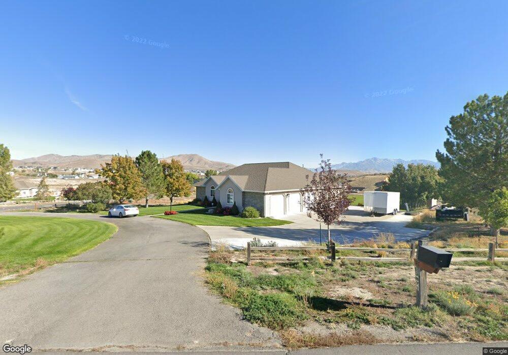
2871 E Cedar Dr Eagle Mountain, UT 84005
Estimated Value: $709,000 - $1,106,584
3
Beds
3
Baths
2,347
Sq Ft
$406/Sq Ft
Est. Value
About This Home
This home is located at 2871 E Cedar Dr, Eagle Mountain, UT 84005 and is currently estimated at $952,396, approximately $405 per square foot. 2871 E Cedar Dr is a home located in Utah County with nearby schools including Hidden Hollow Elementary School, Frontier Middle School, and Cedar Valley High.
Ownership History
Date
Name
Owned For
Owner Type
Purchase Details
Closed on
Jul 3, 2025
Sold by
Cameron Michael A and Cameron Bettina R
Bought by
Cameron Michael A
Current Estimated Value
Home Financials for this Owner
Home Financials are based on the most recent Mortgage that was taken out on this home.
Original Mortgage
$300,000
Outstanding Balance
$296,502
Interest Rate
6.89%
Mortgage Type
New Conventional
Estimated Equity
$655,894
Purchase Details
Closed on
Jun 12, 2025
Sold by
Michael A Cameron A and Michael Bettina R
Bought by
Cameron Michael A and Cameron Bettina R
Home Financials for this Owner
Home Financials are based on the most recent Mortgage that was taken out on this home.
Original Mortgage
$300,000
Outstanding Balance
$296,502
Interest Rate
6.89%
Mortgage Type
New Conventional
Estimated Equity
$655,894
Purchase Details
Closed on
Sep 15, 2022
Sold by
Rose Cameron Michael and Rose Bettina
Bought by
Cameron Michael
Purchase Details
Closed on
May 7, 2020
Sold by
Cameron Michael and Cameron Bettina
Bought by
Cameron Michael and Cameron Bettina Rose
Home Financials for this Owner
Home Financials are based on the most recent Mortgage that was taken out on this home.
Original Mortgage
$275,000
Interest Rate
3.5%
Mortgage Type
New Conventional
Purchase Details
Closed on
Sep 12, 2018
Sold by
Burnham Keith M and Burnham Shirley Y
Bought by
Cameron Michael and Cameron Bettina
Home Financials for this Owner
Home Financials are based on the most recent Mortgage that was taken out on this home.
Original Mortgage
$375,000
Interest Rate
4.6%
Mortgage Type
New Conventional
Purchase Details
Closed on
Mar 25, 1997
Sold by
Burnham Keith M and Burnham Shirley Y
Bought by
Burnham Keith M and Burnham Shirley Y
Purchase Details
Closed on
Sep 18, 1996
Sold by
Burnham Keith M
Bought by
Burnham Keith M and Burnham Shirley Y
Home Financials for this Owner
Home Financials are based on the most recent Mortgage that was taken out on this home.
Original Mortgage
$62,775
Interest Rate
7.88%
Purchase Details
Closed on
Sep 17, 1996
Sold by
Burnham Keith M and Burnham Shirley Y
Bought by
Burnham Keith M and Burnham Shirley Y
Home Financials for this Owner
Home Financials are based on the most recent Mortgage that was taken out on this home.
Original Mortgage
$62,775
Interest Rate
7.88%
Create a Home Valuation Report for This Property
The Home Valuation Report is an in-depth analysis detailing your home's value as well as a comparison with similar homes in the area
Home Values in the Area
Average Home Value in this Area
Purchase History
| Date | Buyer | Sale Price | Title Company |
|---|---|---|---|
| Cameron Michael A | -- | Artisan Title | |
| Cameron Michael A | -- | None Listed On Document | |
| Cameron Michael | -- | -- | |
| Cameron Michael | -- | First American Draper | |
| Cameron Michael | -- | First American Title Ins Co | |
| Burnham Keith M | -- | -- | |
| Burnham Keith M | -- | -- | |
| Burnham Keith M | -- | -- | |
| Burnham Keith | -- | -- | |
| Burnham Keith M | -- | -- |
Source: Public Records
Mortgage History
| Date | Status | Borrower | Loan Amount |
|---|---|---|---|
| Open | Cameron Michael A | $300,000 | |
| Previous Owner | Cameron Michael | $275,000 | |
| Previous Owner | Cameron Michael | $375,000 | |
| Previous Owner | Burnham Keith M | $62,775 |
Source: Public Records
Tax History
| Year | Tax Paid | Tax Assessment Tax Assessment Total Assessment is a certain percentage of the fair market value that is determined by local assessors to be the total taxable value of land and additions on the property. | Land | Improvement |
|---|---|---|---|---|
| 2025 | $4,893 | $567,790 | -- | -- |
| 2024 | $4,673 | $528,740 | $0 | $0 |
| 2023 | $4,673 | $545,350 | $0 | $0 |
| 2022 | $4,597 | $860,400 | $513,900 | $346,500 |
| 2021 | $4,269 | $646,400 | $345,600 | $300,800 |
| 2020 | $4,104 | $607,800 | $320,000 | $287,800 |
| 2019 | $3,663 | $556,000 | $295,000 | $261,000 |
| 2018 | $3,634 | $530,200 | $269,200 | $261,000 |
| 2017 | $3,138 | $276,300 | $0 | $0 |
| 2016 | $3,149 | $259,525 | $0 | $0 |
| 2015 | $3,156 | $246,655 | $0 | $0 |
| 2014 | $3,244 | $250,405 | $0 | $0 |
Source: Public Records
Map
Nearby Homes
- 8176 N Cedar Dr Unit V12
- 3344 E Kennekuk Ln
- 3315 E Appaloosa Way
- 3326 E Caledonia Ave
- 7745 N Mountain Ash Way E Unit 63
- 8204 N Cedar Springs Rd Unit 2
- 7745 E Goshawk Rd Unit 3100
- 1823 E Cedar Dr
- 7939 Dundee Dr
- 3427 Blantrae Way
- 5409 N Sulley Way Unit 414
- 5363 N Sulley Way
- 5379 N Orville St Unit 428
- 2628 E Prairie View Dr
- 3543 E Rock Creek Rd Unit 4
- 8675 N Franklin Dr
- 7644 N Red Kite Way
- 3624 E Clear Rock Rd Unit K3
- 3612 E Ruby Ln
- 3456 E Windhover Cir
- 2871 E Cedar Dr
- 64 N Ranch Rd Unit 64
- 8381 N Ranch Rd
- 8381 N Ranch Rd
- 2812 E Cedar Dr
- 8410 N Ranch Rd
- 8410 N Ranch Rd Unit 83
- 8410 N Ranch Rd Unit 83
- 2941 E Cedar Dr
- 2941 E Cedar Dr
- 2711 E Cedar Dr
- 2711 E Cedar Dr
- 2711 E Cedar Dr Unit 78
- 8257 N Fort Hill Rd
- 2921 N Cedar Valley Hwy
- 2950 E Cedar Dr
- 2843 E Fort Hill Rd
- 8204 Fort Hill Rd
- 2854 E Ranch Rd
- 8272 N Crest Rd Unit 51
Your Personal Tour Guide
Ask me questions while you tour the home.