
288 S 123 W Burley, ID 83318
Estimated payment $3,621/month
Highlights
- Wood Burning Stove
- Great Room
- Formal Dining Room
- Wood Flooring
- Covered Patio or Porch
- Fireplace
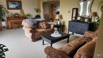
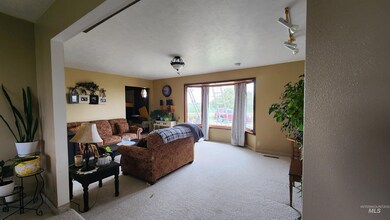
About This Home
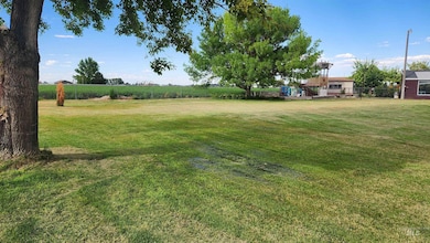
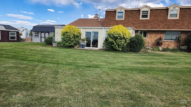
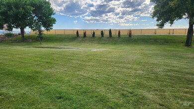
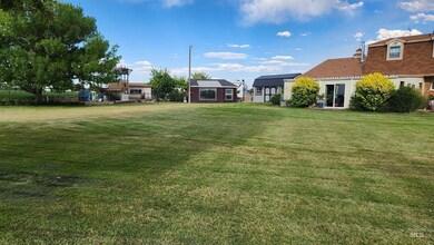
Must See! They don't build them like this anymore. This solid brick 5 bedroom 3 bath home, located south of Burley comes with all the extras. Hardwood floors,solid wood doors, custom made cabinets, formal dining room, living room, family room with wood stove, storage room and recreational room or theater room a large utility room and 2 car garage, lots of storage. Bonus includes an enclosed patio room/hottub room and a separate greenhouse/solarium. Backyard is completely fenced and includes sandbox playground area. Mature trees and sprinkler system with irrigation rights. Room for a garden, RV parking and phenomenal view of Mt. Harrison. Come make this your next home. Contact a local realtor for viewing. BTVAI
Home Details
Home Type
- Single Family
Est. Annual Taxes
- $1,462
Year Built
- Built in 1980
Lot Details
- 1 Acre Lot
- Partially Fenced Property
- Aluminum or Metal Fence
- Sprinkler System
Parking
- 2 Car Attached Garage
Home Design
- Patio Home
- Brick Exterior Construction
- Frame Construction
- Composition Roof
- Vinyl Siding
Interior Spaces
- 2-Story Property
- Plumbed for Central Vacuum
- Fireplace
- Wood Burning Stove
- Great Room
- Family Room
- Formal Dining Room
- Property Views
- Basement
Kitchen
- Breakfast Bar
- Dishwasher
- Laminate Countertops
- Disposal
Flooring
- Wood
- Carpet
- Laminate
- Tile
Bedrooms and Bathrooms
- 5 Bedrooms
- En-Suite Primary Bedroom
- 4 Bathrooms
- Walk-in Shower
Outdoor Features
- Covered Patio or Porch
- Outdoor Storage
Schools
- John V Evans Elementary School
- Burley Jr High Middle School
- Burley High School
Farming
- Chicken Farm
Utilities
- Forced Air Heating and Cooling System
- Wood Insert Heater
- Well
- Electric Water Heater
- Septic Tank
Listing and Financial Details
- Assessor Parcel Number RP11S22E019200
Map
Tax History
| Year | Tax Paid | Tax Assessment Tax Assessment Total Assessment is a certain percentage of the fair market value that is determined by local assessors to be the total taxable value of land and additions on the property. | Land | Improvement |
|---|---|---|---|---|
| 2024 | $1,347 | $405,703 | $25,598 | $380,105 |
| 2023 | $1,547 | $405,703 | $25,598 | $380,105 |
| 2022 | $1,569 | $347,720 | $25,598 | $322,122 |
| 2021 | $1,352 | $283,865 | $25,598 | $258,267 |
| 2020 | $1,233 | $238,300 | $18,962 | $219,338 |
| 2019 | $1,189 | $230,845 | $17,889 | $212,956 |
| 2017 | $1,067 | $212,407 | $14,520 | $197,887 |
| 2016 | $1,055 | $206,643 | $14,520 | $192,123 |
| 2015 | $1,073 | $205,323 | $13,200 | $192,123 |
| 2014 | $1,162 | $205,323 | $13,200 | $192,123 |
| 2013 | $1,162 | $209,743 | $17,738 | $192,005 |
Property History
| Date | Event | Price | List to Sale | Price per Sq Ft |
|---|---|---|---|---|
| 02/20/2026 02/20/26 | Price Changed | $679,900 | -2.9% | $160 / Sq Ft |
| 11/14/2025 11/14/25 | Price Changed | $699,900 | -4.8% | $165 / Sq Ft |
| 11/03/2025 11/03/25 | For Sale | $735,000 | -- | $173 / Sq Ft |
Purchase History
| Date | Type | Sale Price | Title Company |
|---|---|---|---|
| Interfamily Deed Transfer | -- | -- | |
| Quit Claim Deed | -- | Land Title And Escrow |
Mortgage History
| Date | Status | Loan Amount | Loan Type |
|---|---|---|---|
| Open | $186,861 | FHA | |
| Previous Owner | $55,800 | Credit Line Revolving |
Source: Intermountain MLS
MLS Number: 98966511
APN: RP11S22E019200
Disclaimer: Certain information contained herein is derived from information provided by parties other than Homes.com. All information provided is deemed reliable, but is not guaranteed to be accurate and should be independently verified.
![]() IDX information is provided exclusively for consumers’ personal, non-commercial use, that it may not be used for any purpose other than to identify prospective properties consumers may be interested in purchasing. IMLS does not assume any liability for missing or inaccurate data.
IDX information is provided exclusively for consumers’ personal, non-commercial use, that it may not be used for any purpose other than to identify prospective properties consumers may be interested in purchasing. IMLS does not assume any liability for missing or inaccurate data.
Information provided by IMLS is deemed reliable but not guaranteed.
- 525 E 150 S
- 294 S 100 W
- 221 S 30 W
- 160 S 100 W
- 262 Ferdinand Cir
- 642 Clear Springs St
- 273 W 100 S
- TBD 300 S Lot 4
- TBD 300 S Lot 3
- 431 Pratt Place
- TBD 300 S Lot 1
- TBD 300 S Lot 2
- 422 Parish Ct
- 2403 Yellowstone Trail
- 3449 Hiland Ave
- 2608 Miller Ave
- 321 Dennis Dr
- 201 E 27th St
- 1017 Coventry Ln
- 89 S 222 W

Ask me questions while you tour the home.