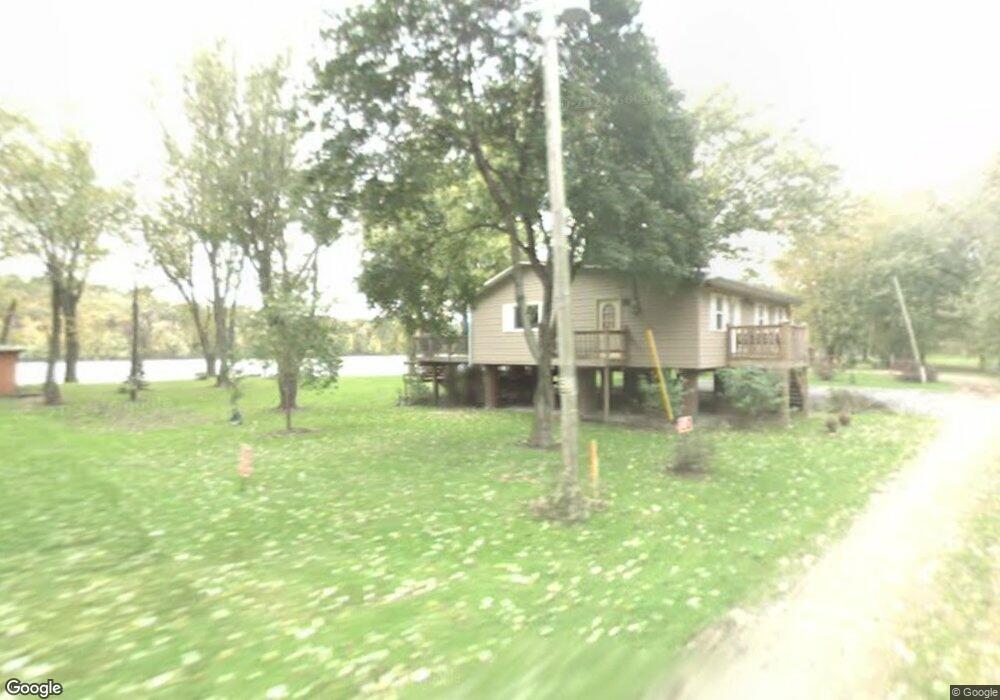
2881 S Brooks Island Rd Oregon, IL 61061
Estimated Value: $125,358 - $189,000
2
Beds
1
Bath
864
Sq Ft
$180/Sq Ft
Est. Value
About This Home
This home is located at 2881 S Brooks Island Rd, Oregon, IL 61061 and is currently estimated at $155,090, approximately $179 per square foot. 2881 S Brooks Island Rd is a home located in Ogle County with nearby schools including Oregon Elementary School, David L. Rahn Junior High School, and Oregon High School.
Ownership History
Date
Name
Owned For
Owner Type
Purchase Details
Closed on
Oct 26, 2022
Sold by
Weir Edward J and Weir Shilrley A
Bought by
Weir Trust
Current Estimated Value
Purchase Details
Closed on
Aug 5, 2011
Sold by
Shriver David W
Bought by
Weir Edward and Weir Shirley
Purchase Details
Closed on
Aug 24, 2005
Sold by
Osterhoff Wayne A and Osterhoff Theresa J
Bought by
Shriver David W and Shriver Sybil K
Create a Home Valuation Report for This Property
The Home Valuation Report is an in-depth analysis detailing your home's value as well as a comparison with similar homes in the area
Home Values in the Area
Average Home Value in this Area
Purchase History
| Date | Buyer | Sale Price | Title Company |
|---|---|---|---|
| Weir Trust | -- | None Available | |
| Weir Edward | $100,000 | None Available | |
| Shriver David W | $142,500 | None Available |
Source: Public Records
Tax History Compared to Growth
Tax History
| Year | Tax Paid | Tax Assessment Tax Assessment Total Assessment is a certain percentage of the fair market value that is determined by local assessors to be the total taxable value of land and additions on the property. | Land | Improvement |
|---|---|---|---|---|
| 2024 | $2,736 | $31,229 | $6,698 | $24,531 |
| 2023 | $2,022 | $28,201 | $7,852 | $20,349 |
| 2022 | $3,335 | $37,366 | $7,268 | $30,098 |
| 2021 | $3,139 | $34,866 | $6,782 | $28,084 |
| 2020 | $3,035 | $33,320 | $6,481 | $26,839 |
| 2019 | $3,011 | $33,154 | $6,449 | $26,705 |
| 2018 | $2,875 | $31,726 | $6,171 | $25,555 |
| 2017 | $2,321 | $31,726 | $6,171 | $25,555 |
| 2016 | $2,199 | $30,615 | $5,955 | $24,660 |
| 2015 | $2,178 | $31,693 | $6,165 | $25,528 |
| 2014 | $2,215 | $31,693 | $6,165 | $25,528 |
| 2013 | $3,010 | $33,270 | $6,472 | $26,798 |
Source: Public Records
Map
Nearby Homes
- 2811 S Brooks Island Rd
- 000 Austin Ct
- 000 W Pines Rd
- 1912 S Daysville Rd
- 1107 S 2nd St
- 000 S Anterior Rd
- 2765 W Pines Rd
- 1071 E Honey Creek Rd
- 707 S 7th St
- 711 S 3rd St
- 000 Smith (Lot 31) Dr
- 000 Woods (Lot 26) Dr
- 1162 S Bradley Ln
- 308 S 8th St
- 503 S 3rd St
- 908 Madison St
- 104 S 10th St
- 104 N 13th St
- 708 W Washington St
- 213 N 4th St
- 2881 S Brooks Island Rd
- 2875 S Brooks Island Rd
- 2871 S Brooks Island Rd
- 2867 S Brooks Island Rd
- 2863 S Brooks Island Rd
- 2919 S Brooks Island Rd
- 2859 Brookes Isle Rd
- 2855 S Brooks Island Rd
- 2855 S Brooks Island Rd
- 2849 S Brooks Island Rd
- 985 W Castle Rd
- 2847 S Brooks Island Rd
- 2843 S Brooks Island Rd
- 2843 S Brooks Island Rd
- 2839 S Brooks Island Rd
- 993 W Castle Rd
- 2835 S Brooks Island Rd
- 2819 S Brooks Island Rd
- 2836 S Brooks Island Rd
- 2815 S Brooks Island Rd