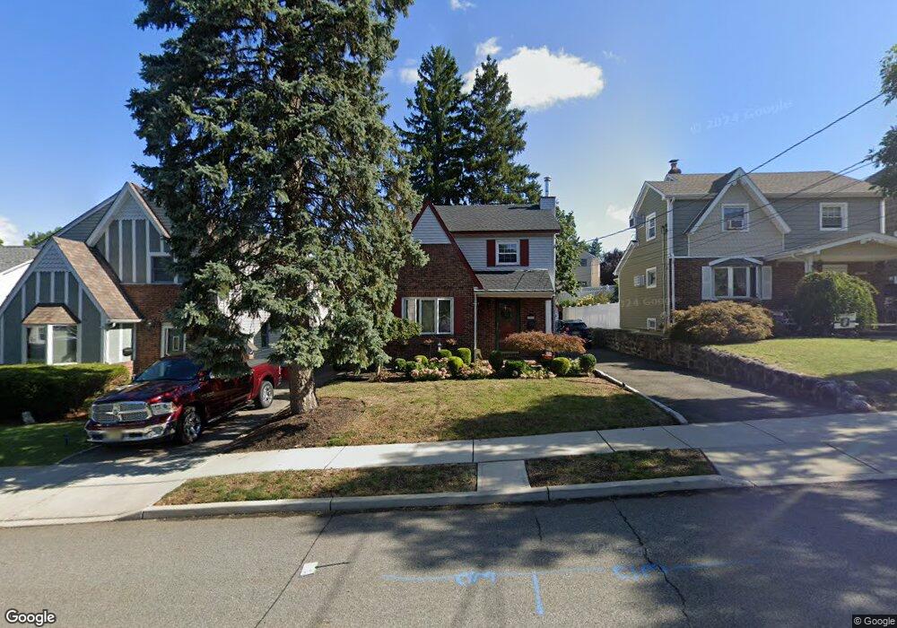
289 Innes Rd Wood Ridge, NJ 07075
Estimated Value: $662,282 - $765,000
--
Bed
--
Bath
1,952
Sq Ft
$370/Sq Ft
Est. Value
About This Home
This home is located at 289 Innes Rd, Wood Ridge, NJ 07075 and is currently estimated at $721,571, approximately $369 per square foot. 289 Innes Rd is a home located in Bergen County with nearby schools including Catherine E. Doyle Elementary School, Wood Ridge Intermediate School, and Wood Ridge High School.
Ownership History
Date
Name
Owned For
Owner Type
Purchase Details
Closed on
Mar 15, 2001
Current Estimated Value
Purchase Details
Closed on
Jul 13, 1994
Sold by
Decarolis Gregg and Decarolis Denise
Bought by
Cordes Paul and Bolcar Kathy
Home Financials for this Owner
Home Financials are based on the most recent Mortgage that was taken out on this home.
Original Mortgage
$134,000
Interest Rate
8.19%
Purchase Details
Closed on
Jan 18, 1994
Sold by
Simorelli Louis and Simorelli Liberta
Bought by
Decarolis Gregg and Decarolis Denise
Home Financials for this Owner
Home Financials are based on the most recent Mortgage that was taken out on this home.
Original Mortgage
$66,000
Interest Rate
7.22%
Create a Home Valuation Report for This Property
The Home Valuation Report is an in-depth analysis detailing your home's value as well as a comparison with similar homes in the area
Home Values in the Area
Average Home Value in this Area
Purchase History
| Date | Buyer | Sale Price | Title Company |
|---|---|---|---|
| -- | -- | -- | |
| Cordes Paul | $168,000 | -- | |
| Decarolis Gregg | $94,000 | -- |
Source: Public Records
Mortgage History
| Date | Status | Borrower | Loan Amount |
|---|---|---|---|
| Previous Owner | Cordes Paul | $134,000 | |
| Previous Owner | Decarolis Gregg | $66,000 |
Source: Public Records
Tax History Compared to Growth
Tax History
| Year | Tax Paid | Tax Assessment Tax Assessment Total Assessment is a certain percentage of the fair market value that is determined by local assessors to be the total taxable value of land and additions on the property. | Land | Improvement |
|---|---|---|---|---|
| 2025 | $11,294 | $393,800 | $194,700 | $199,100 |
| 2024 | $11,125 | $393,800 | $194,700 | $199,100 |
| 2023 | $11,007 | $393,800 | $194,700 | $199,100 |
| 2022 | $11,007 | $393,800 | $194,700 | $199,100 |
| 2021 | $11,117 | $393,800 | $194,700 | $199,100 |
| 2020 | $11,089 | $393,800 | $194,700 | $199,100 |
| 2019 | $10,924 | $393,800 | $194,700 | $199,100 |
| 2018 | $10,566 | $393,800 | $194,700 | $199,100 |
| 2017 | $10,318 | $393,800 | $194,700 | $199,100 |
| 2016 | $7,241 | $188,900 | $113,900 | $75,000 |
| 2015 | $7,118 | $188,900 | $113,900 | $75,000 |
| 2014 | $6,972 | $188,900 | $113,900 | $75,000 |
Source: Public Records
Map
Nearby Homes
- 88 Roosevelt Dr
- 289 Valley Blvd Unit 1A
- 289 Valley Blvd Unit 1D
- 289 Bradley Dr
- 271 North Ave
- 432 Innes Rd
- 39 Arnold Dr
- 102 Wesmont Dr
- 82 Wesmont Dr
- 68 Wesmont Dr
- 68 Wesmont Dr Unit 3803
- 148 12th St
- 181 Wood Ridge Ave
- 109 Wesmont Dr
- 317 Hillcrest Ave
- 27 Roosevelt Dr
- 25 Roosevelt Dr
- 38 Springfield Ave
- 243 Cleveland Ave
- 311 Harrison Ave