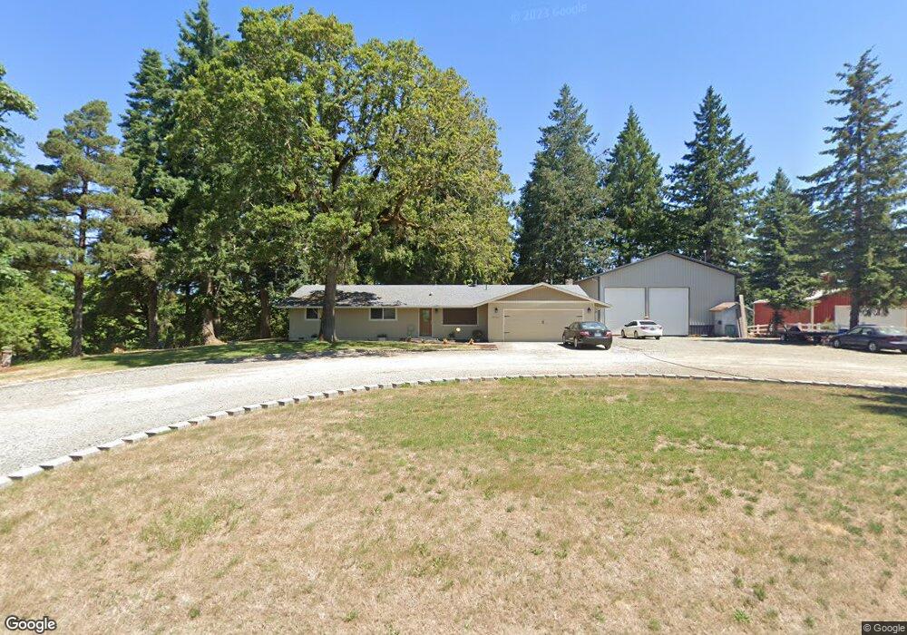
28962 S Dalmatian Rd Mulino, OR 97042
Estimated Value: $678,000 - $737,921
3
Beds
2
Baths
1,596
Sq Ft
$438/Sq Ft
Est. Value
About This Home
This home is located at 28962 S Dalmatian Rd, Mulino, OR 97042 and is currently estimated at $698,980, approximately $437 per square foot. 28962 S Dalmatian Rd is a home located in Clackamas County with nearby schools including Country Christian School.
Ownership History
Date
Name
Owned For
Owner Type
Purchase Details
Closed on
Feb 4, 2025
Sold by
Mitchell Tyler
Bought by
Mitchell Tyler and Mitchell Renee
Current Estimated Value
Purchase Details
Closed on
Feb 26, 2009
Sold by
Bell Frederick H and Tennison Carol Jean
Bought by
Mitchell Tyler
Home Financials for this Owner
Home Financials are based on the most recent Mortgage that was taken out on this home.
Original Mortgage
$275,510
Interest Rate
5.19%
Mortgage Type
Purchase Money Mortgage
Purchase Details
Closed on
Oct 22, 2007
Sold by
Bell Frederick H H
Bought by
Bell Frederick H
Home Financials for this Owner
Home Financials are based on the most recent Mortgage that was taken out on this home.
Original Mortgage
$457,425
Interest Rate
5.24%
Mortgage Type
Reverse Mortgage Home Equity Conversion Mortgage
Purchase Details
Closed on
Feb 3, 2003
Sold by
Bell Frederick H and Jagow Bell Karla A
Bought by
Bell Frederick H and Jagow Bell Karla A
Create a Home Valuation Report for This Property
The Home Valuation Report is an in-depth analysis detailing your home's value as well as a comparison with similar homes in the area
Home Values in the Area
Average Home Value in this Area
Purchase History
| Date | Buyer | Sale Price | Title Company |
|---|---|---|---|
| Mitchell Tyler | -- | None Listed On Document | |
| Mitchell Tyler | $270,000 | First American Title Insuran | |
| Bell Frederick H | -- | Pacific Nw Title | |
| Bell Frederick H | -- | -- |
Source: Public Records
Mortgage History
| Date | Status | Borrower | Loan Amount |
|---|---|---|---|
| Previous Owner | Mitchell Tyler | $275,510 | |
| Previous Owner | Bell Frederick H | $457,425 |
Source: Public Records
Tax History Compared to Growth
Tax History
| Year | Tax Paid | Tax Assessment Tax Assessment Total Assessment is a certain percentage of the fair market value that is determined by local assessors to be the total taxable value of land and additions on the property. | Land | Improvement |
|---|---|---|---|---|
| 2025 | $4,653 | $338,131 | -- | -- |
| 2024 | $4,495 | $328,283 | -- | -- |
| 2023 | $4,495 | $318,725 | $0 | $0 |
| 2022 | $3,665 | $301,144 | $0 | $0 |
| 2021 | $3,151 | $262,646 | $0 | $0 |
| 2020 | $2,846 | $236,232 | $0 | $0 |
| 2019 | $2,765 | $229,353 | $0 | $0 |
| 2018 | $2,691 | $222,675 | $0 | $0 |
| 2017 | $2,544 | $216,188 | $0 | $0 |
| 2016 | $2,391 | $209,891 | $0 | $0 |
| 2015 | $2,325 | $203,778 | $0 | $0 |
| 2014 | $2,225 | $197,843 | $0 | $0 |
Source: Public Records
Map
Nearby Homes
- 29333 S Marshall Rd
- 15441 S Union Mills Rd
- 28381 S Salo Rd
- 15047 S MacKsburg Rd
- 28502 Oregon 213
- 28502 S Highway 213
- 14001 S Union Mills Rd
- 16290 S Riverview Rd
- 15706 S Highway 211
- 29891 S Highway 213
- 13920 S Lucia Ln
- B2 Plan at River Meadows
- C2 Plan at River Meadows
- A1 Plan at River Meadows
- B2b Plan at River Meadows
- A2 Plan at River Meadows
- 1341 Rachel Ln
- 1101 Rachel Ln
- 1241 Rachel Ln
- 1291 Rachel Ln
- 28955 S Dalmatian Rd
- 28982 S Dalmatian Rd
- 28931 S Dalmatian Rd
- 15185 S Paradise Ln
- 28895 S Dalmatian Rd
- 15353 S Paradise Ln
- 15190 S Paradise Ln
- 28790 S Dalmatian Rd
- 15250 S Paradise Ln
- 28691 S Dalmatian Rd
- 28778 S Dalmatian Rd
- 28690 S Heisinger Ln
- 28700 S Dalmatian Rd
- 28677 S Dalmatian Rd
- 15413 S Paradise Ln
- 28750 S Heisinger Ln
- 28644 S Heisinger Ln
- 28668 S Dalmatian Rd
- 15435 S Paradise Ln
- 28656 S Dalmatian Rd