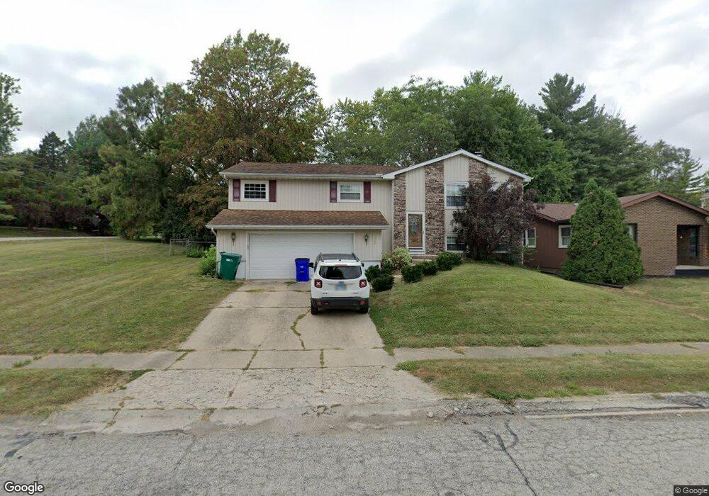
2899 S Forrest Ln Decatur, IL 62521
Bayshore NeighborhoodEstimated Value: $197,070 - $225,000
4
Beds
3
Baths
2,632
Sq Ft
$79/Sq Ft
Est. Value
About This Home
This home is located at 2899 S Forrest Ln, Decatur, IL 62521 and is currently estimated at $208,018, approximately $79 per square foot. 2899 S Forrest Ln is a home located in Macon County with nearby schools including Meridian Middle School, Meridian High School, and Holy Family Catholic School.
Ownership History
Date
Name
Owned For
Owner Type
Purchase Details
Closed on
Feb 7, 2011
Sold by
Adams Brian and Adams Dana
Bought by
Smith Tracy R and Smith Renee L
Current Estimated Value
Home Financials for this Owner
Home Financials are based on the most recent Mortgage that was taken out on this home.
Original Mortgage
$162,500
Outstanding Balance
$110,946
Interest Rate
4.81%
Mortgage Type
New Conventional
Estimated Equity
$97,072
Purchase Details
Closed on
Sep 1, 2006
Sold by
Maupin Christopher S and Maupin Kerry J
Bought by
Adams Brian and Adams Dana
Home Financials for this Owner
Home Financials are based on the most recent Mortgage that was taken out on this home.
Original Mortgage
$100,600
Interest Rate
6.23%
Mortgage Type
New Conventional
Purchase Details
Closed on
Nov 1, 2003
Create a Home Valuation Report for This Property
The Home Valuation Report is an in-depth analysis detailing your home's value as well as a comparison with similar homes in the area
Home Values in the Area
Average Home Value in this Area
Purchase History
| Date | Buyer | Sale Price | Title Company |
|---|---|---|---|
| Smith Tracy R | $162,500 | Central Illinois Title Co | |
| Adams Brian | $135,000 | None Available | |
| -- | $135,000 | -- |
Source: Public Records
Mortgage History
| Date | Status | Borrower | Loan Amount |
|---|---|---|---|
| Open | Smith Tracy R | $162,500 | |
| Previous Owner | Adams Brian | $100,600 |
Source: Public Records
Tax History Compared to Growth
Tax History
| Year | Tax Paid | Tax Assessment Tax Assessment Total Assessment is a certain percentage of the fair market value that is determined by local assessors to be the total taxable value of land and additions on the property. | Land | Improvement |
|---|---|---|---|---|
| 2024 | $4,007 | $54,733 | $8,942 | $45,791 |
| 2023 | $4,001 | $52,795 | $8,625 | $44,170 |
| 2022 | $3,718 | $48,854 | $7,982 | $40,872 |
| 2021 | $3,532 | $45,625 | $7,454 | $38,171 |
| 2020 | $4,199 | $43,507 | $7,108 | $36,399 |
| 2019 | $4,199 | $43,507 | $7,108 | $36,399 |
| 2018 | $3,907 | $40,836 | $7,636 | $33,200 |
| 2017 | $4,009 | $41,926 | $7,840 | $34,086 |
| 2016 | $4,088 | $42,354 | $7,920 | $34,434 |
| 2015 | $3,951 | $41,605 | $7,780 | $33,825 |
| 2014 | $3,737 | $41,193 | $7,703 | $33,490 |
| 2013 | $3,899 | $42,740 | $7,992 | $34,748 |
Source: Public Records
Map
Nearby Homes
- 2626 S Forrest Green Dr
- 2628 S Forrest Green Dr
- 2605 S Forrest Green Dr
- 98 Ridgeway Dr
- 0 E Danceland Rd
- 43 Ridgedale Dr
- 405 Hackberry Dr
- 20 Ridge Dr
- 411 Woodhill Dr
- 1842 Race Dr
- 19 Peggy Ann Dr
- 65 S Shores Dr
- 102 Phillips Dr
- 0 S Shores Dr
- 320 Hackberry Place
- 3020 S Laura St
- 23 La Salle Dr
- 0 Wildwood Ct
- 435 Dawson Rd
- 2330 S Shores Dr
- 2879 S Forrest Ln
- 2870 S Forrest Green Dr
- 2890 S Forrest Green Dr
- 2859 S Forrest Ln
- 2850 S Forrest Green Dr
- 2849 S Forrest Ln
- 2874 S Forrest Ln
- 2894 S Forrest Ln
- 2840 S Forrest Green Dr
- 2864 S Forrest Ln
- 0 E Grove Rd
- 2839 S Forrest Ln
- 985 E Grove Rd
- 2854 S Forrest Ln
- 2830 S Forrest Green Dr
- 2841 S Forrest Green Dr
- 2844 S Forrest Ln
- 2891 S Forrest Green Dr
- 2821 S Forrest Green Dr
- 925 E Grove Rd