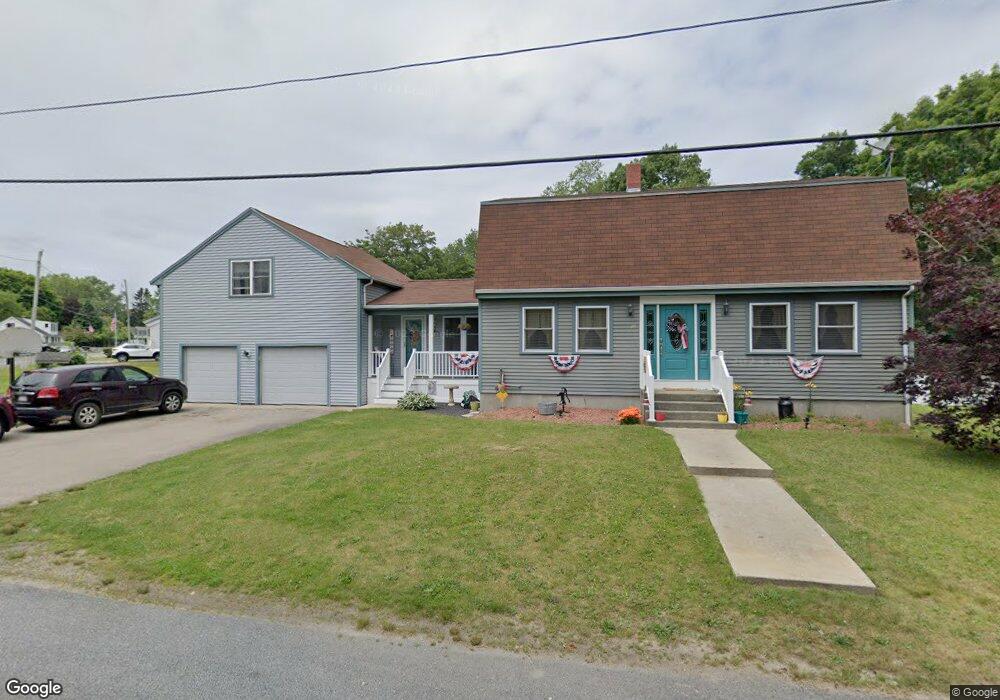
29 Arlington Ave Westport, MA 02790
North Westport NeighborhoodEstimated Value: $612,000 - $795,000
3
Beds
2
Baths
2,688
Sq Ft
$249/Sq Ft
Est. Value
About This Home
This home is located at 29 Arlington Ave, Westport, MA 02790 and is currently estimated at $670,466, approximately $249 per square foot. 29 Arlington Ave is a home located in Bristol County with nearby schools including Alice A. Macomber Primary School, Westport Elementary School, and Westport Middle-High School.
Ownership History
Date
Name
Owned For
Owner Type
Purchase Details
Closed on
Oct 24, 1973
Bought by
Barrette Raymond J and Barrette Janice J
Current Estimated Value
Create a Home Valuation Report for This Property
The Home Valuation Report is an in-depth analysis detailing your home's value as well as a comparison with similar homes in the area
Home Values in the Area
Average Home Value in this Area
Purchase History
| Date | Buyer | Sale Price | Title Company |
|---|---|---|---|
| Barrette Raymond J | -- | -- |
Source: Public Records
Mortgage History
| Date | Status | Borrower | Loan Amount |
|---|---|---|---|
| Open | Barrette Raymond J | $297,500 | |
| Closed | Barrette Raymond J | $72,250 |
Source: Public Records
Tax History Compared to Growth
Tax History
| Year | Tax Paid | Tax Assessment Tax Assessment Total Assessment is a certain percentage of the fair market value that is determined by local assessors to be the total taxable value of land and additions on the property. | Land | Improvement |
|---|---|---|---|---|
| 2025 | $3,580 | $480,600 | $150,300 | $330,300 |
| 2024 | $3,581 | $463,200 | $139,300 | $323,900 |
| 2023 | $3,492 | $427,900 | $126,300 | $301,600 |
| 2022 | $3,282 | $387,000 | $120,000 | $267,000 |
| 2021 | $3,242 | $376,100 | $109,100 | $267,000 |
| 2020 | $3,004 | $356,400 | $99,200 | $257,200 |
| 2019 | $2,884 | $348,700 | $99,200 | $249,500 |
| 2018 | $2,431 | $297,500 | $86,400 | $211,100 |
| 2017 | $2,340 | $293,600 | $92,400 | $201,200 |
| 2016 | $2,344 | $296,300 | $87,600 | $208,700 |
| 2015 | $2,226 | $280,700 | $100,700 | $180,000 |
Source: Public Records
Map
Nearby Homes
- 116 Gifford Rd
- 80 Gifford Rd
- 15 S Breault St
- 16 S Berryman St
- 23 Donna St
- 380 Gifford Rd
- 565 Highland Ave
- 79 Center St
- 100 D Dr
- 27 Dias Ave
- 3 Diane Way
- 1276 Old Fall River Rd
- 96 Forge Rd
- 29 Union Ave
- 56 Lakeside Ave
- 2 Donna Marie Dr
- 92 Benoit St
- 55 Lakeside Ave
- 818 Reed Rd
- 3 Roller Coaster Way Unit Lot 1