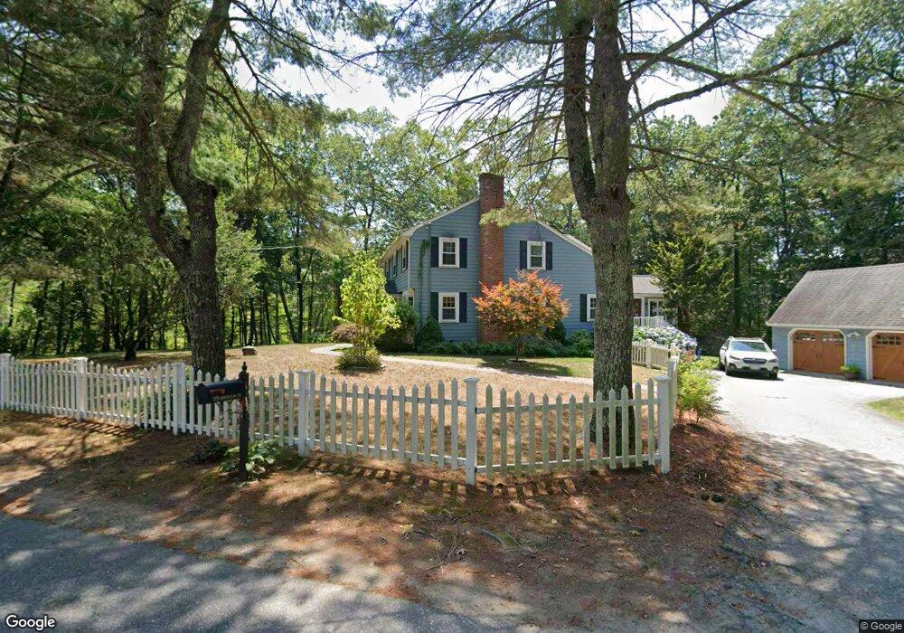
29 Bingham Rd Carlisle, MA 01741
Estimated Value: $1,325,000 - $1,534,000
4
Beds
3
Baths
3,434
Sq Ft
$409/Sq Ft
Est. Value
About This Home
This home is located at 29 Bingham Rd, Carlisle, MA 01741 and is currently estimated at $1,406,143, approximately $409 per square foot. 29 Bingham Rd is a home located in Middlesex County with nearby schools including Carlisle School and Middlesex School.
Ownership History
Date
Name
Owned For
Owner Type
Purchase Details
Closed on
Oct 15, 2009
Sold by
Kimball Peter J and Kimball Lucia M
Bought by
Hentemann Martin F and Monahan Mary Katherine
Current Estimated Value
Home Financials for this Owner
Home Financials are based on the most recent Mortgage that was taken out on this home.
Original Mortgage
$523,750
Outstanding Balance
$343,047
Interest Rate
5.14%
Mortgage Type
Purchase Money Mortgage
Estimated Equity
$1,063,096
Purchase Details
Closed on
Oct 7, 1997
Sold by
Merrill Rosamond S
Bought by
Kimball Peter J and Kimball Lucia M
Home Financials for this Owner
Home Financials are based on the most recent Mortgage that was taken out on this home.
Original Mortgage
$240,000
Interest Rate
7.41%
Mortgage Type
Purchase Money Mortgage
Create a Home Valuation Report for This Property
The Home Valuation Report is an in-depth analysis detailing your home's value as well as a comparison with similar homes in the area
Home Values in the Area
Average Home Value in this Area
Purchase History
| Date | Buyer | Sale Price | Title Company |
|---|---|---|---|
| Hentemann Martin F | $700,000 | -- | |
| Kimball Peter J | $359,000 | -- |
Source: Public Records
Mortgage History
| Date | Status | Borrower | Loan Amount |
|---|---|---|---|
| Open | Hentemann Martin F | $523,750 | |
| Previous Owner | Kimball Peter J | $240,000 | |
| Previous Owner | Kimball Peter J | $240,000 |
Source: Public Records
Tax History Compared to Growth
Tax History
| Year | Tax Paid | Tax Assessment Tax Assessment Total Assessment is a certain percentage of the fair market value that is determined by local assessors to be the total taxable value of land and additions on the property. | Land | Improvement |
|---|---|---|---|---|
| 2025 | $14,138 | $1,072,700 | $547,500 | $525,200 |
| 2024 | $13,797 | $1,035,000 | $503,900 | $531,100 |
| 2023 | $13,642 | $964,100 | $502,900 | $461,200 |
| 2022 | $12,840 | $778,200 | $414,900 | $363,300 |
| 2021 | $12,669 | $778,200 | $414,900 | $363,300 |
| 2020 | $12,689 | $691,100 | $327,800 | $363,300 |
| 2019 | $12,450 | $680,700 | $327,800 | $352,900 |
| 2018 | $12,368 | $680,700 | $327,800 | $352,900 |
| 2017 | $11,879 | $674,200 | $327,800 | $346,400 |
| 2016 | $11,596 | $674,200 | $327,800 | $346,400 |
| 2015 | $11,216 | $590,300 | $314,700 | $275,600 |
| 2014 | $11,003 | $590,300 | $314,700 | $275,600 |
Source: Public Records
Map
Nearby Homes
- 1 Garrison Way Unit 1
- 232 Baldwin Rd
- 225 Lowell St
- 1420 Curve St
- 8 Kay's Walk Unit 13
- 14 Kay's Walk
- 6 Kay's Walk Unit 6
- 6 Kay's Walk
- 2 Kay's Walk Unit 18
- 4 Kay's Walk Unit 15
- 3 Kay's Walk
- 15 Kay's Walk
- 1 Kay's Walk Unit 1
- 1 Kay's Walk
- 13 Kay's Walk
- 15 Kay's Walk Unit 4
- 3 Kay's Walk Unit 3
- 1056 Curve St
- 383 E Riding Dr
- 282 Brook St
- 51 Bingham Rd
- 24 Bingham Rd
- 48 Bingham Rd
- 48 Bingham Rd Unit 1,48
- 328 Concord St
- 333 Concord St
- 400 Concord St
- Lt K-2 Bedford St
- LOT 7 Ice Pond Rd
- 365 Concord St
- 87 Bingham Rd
- 300 Concord St
- 301 Concord St
- 399 Concord St
- 399 Concord St Unit 1
- 94 Bingham Rd
- 119 Bingham Rd
- 438 Concord St
- 442 Concord St
- 272 Concord St