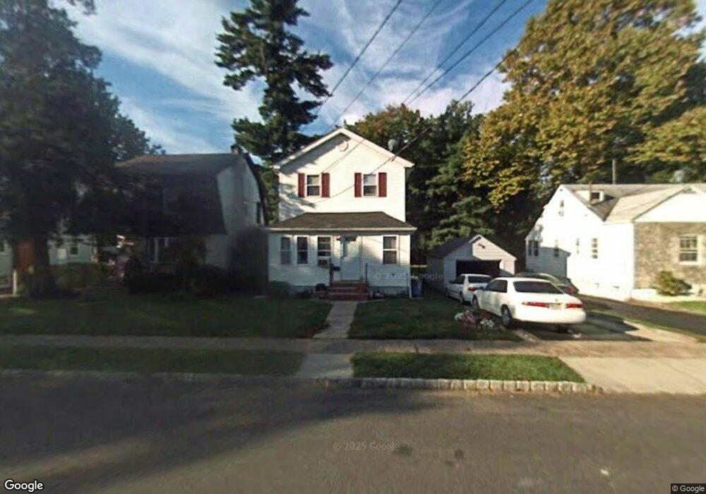
29 Brook St Springfield, NJ 07081
Estimated Value: $611,000 - $705,000
Studio
--
Bath
1,892
Sq Ft
$350/Sq Ft
Est. Value
About This Home
This home is located at 29 Brook St, Springfield, NJ 07081 and is currently estimated at $661,349, approximately $349 per square foot. 29 Brook St is a home located in Union County with nearby schools including Jonathan Dayton High School and St James The Apostle School.
Ownership History
Date
Name
Owned For
Owner Type
Purchase Details
Closed on
Sep 17, 2001
Sold by
Soto Hector D
Bought by
Soto Zoila C
Current Estimated Value
Purchase Details
Closed on
Sep 9, 1998
Sold by
Volante Katherine and Slipka Joseph
Bought by
Soto Hector D and Soto Zoila C
Home Financials for this Owner
Home Financials are based on the most recent Mortgage that was taken out on this home.
Original Mortgage
$129,600
Outstanding Balance
$27,684
Interest Rate
6.9%
Estimated Equity
$633,665
Create a Home Valuation Report for This Property
The Home Valuation Report is an in-depth analysis detailing your home's value as well as a comparison with similar homes in the area
Home Values in the Area
Average Home Value in this Area
Purchase History
| Date | Buyer | Sale Price | Title Company |
|---|---|---|---|
| Soto Zoila C | -- | Chicago Title Insurance Co | |
| Soto Hector D | $144,000 | Chicago Title Insurance Co |
Source: Public Records
Mortgage History
| Date | Status | Borrower | Loan Amount |
|---|---|---|---|
| Open | Soto Hector D | $129,600 |
Source: Public Records
Tax History
| Year | Tax Paid | Tax Assessment Tax Assessment Total Assessment is a certain percentage of the fair market value that is determined by local assessors to be the total taxable value of land and additions on the property. | Land | Improvement |
|---|---|---|---|---|
| 2025 | $11,854 | $499,100 | $185,000 | $314,100 |
| 2024 | $11,659 | $499,100 | $185,000 | $314,100 |
| 2023 | $11,659 | $499,100 | $185,000 | $314,100 |
| 2022 | $10,825 | $499,100 | $185,000 | $314,100 |
| 2021 | $9,276 | $124,600 | $48,300 | $76,300 |
| 2020 | $9,132 | $124,600 | $48,300 | $76,300 |
| 2019 | $9,009 | $124,600 | $48,300 | $76,300 |
| 2018 | $8,847 | $124,600 | $48,300 | $76,300 |
| 2017 | $8,604 | $124,600 | $48,300 | $76,300 |
| 2016 | $8,437 | $124,600 | $48,300 | $76,300 |
| 2015 | $8,338 | $124,600 | $48,300 | $76,300 |
| 2014 | $8,181 | $124,600 | $48,300 | $76,300 |
Source: Public Records
Map
Nearby Homes
- 24 Brook St
- 445 Morris Ave Unit 4C
- 445 Morris Ave Unit 11D
- 445 Morris Ave Unit D11
- 33 Springbrook Rd
- 182 Meisel Ave
- 20 Maple Ave
- 298 Main St
- 294 Mountain Ave
- 238 Riverside Dr
- 270 Main St Unit D
- 17 Alvin Terrace
- 2 S Audlen Terrace
- 8 Willow St
- 27 Willow St Unit A
- 67 Battle Hill Ave
- 7 Willow St
- 5B Troy Dr Unit 1
- 105 Battle Hill Ave
- 221 Main St
Your Personal Tour Guide
Ask me questions while you tour the home.