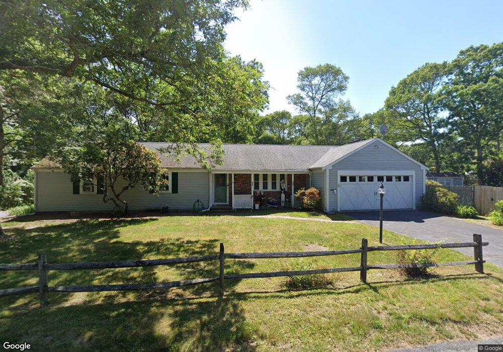
29 Buckskin Path Centerville, MA 02632
Centerville NeighborhoodEstimated Value: $681,868
About This Home
This home is located at 29 Buckskin Path, Centerville, MA 02632 and is currently priced at $681,868, approximately $378 per square foot. 29 Buckskin Path is a home located in Barnstable County.
Ownership History
We collect this data history from publicly available records. To have your information removed, we recommend requesting removal directly through your county’s website.
Purchase Details
Home Values in the Area
Average Home Value in this Area
Purchase History
We collect this data history from publicly available records. To have your information removed, we recommend requesting removal directly through your county’s website.
| Date | Buyer | Sale Price | Title Company |
|---|---|---|---|
| $170,000 | -- |
Mortgage History
We collect this data history from publicly available records. To have your information removed, we recommend requesting removal directly through your county’s website.
| Date | Status | Borrower | Loan Amount |
|---|---|---|---|
| Open | $80,000 | ||
| Previous Owner | $125,000 |
Tax History
We collect this data history from publicly available records. To have your information removed, we recommend requesting removal directly through your county’s website.
| Year | Tax Paid | Tax Assessment Tax Assessment Total Assessment is a certain percentage of the fair market value that is determined by local assessors to be the total taxable value of land and additions on the property. | Land | Improvement |
|---|---|---|---|---|
| 2025 | $4,615 | $570,500 | $153,200 | $417,300 |
| 2024 | $4,370 | $559,500 | $153,200 | $406,300 |
| 2023 | $4,109 | $492,700 | $139,300 | $353,400 |
| 2022 | $4,006 | $415,600 | $103,200 | $312,400 |
| 2021 | $1,016 | $365,300 | $103,200 | $262,100 |
| 2020 | $3,877 | $353,700 | $103,200 | $250,500 |
| 2019 | $1,019 | $327,100 | $103,200 | $223,900 |
| 2018 | $3,386 | $301,800 | $108,600 | $193,200 |
| 2017 | $1,145 | $287,000 | $108,600 | $178,400 |
| 2016 | $3,138 | $287,900 | $109,500 | $178,400 |
| 2015 | $3,084 | $284,200 | $106,400 | $177,800 |
Map
- 49 Powderhorn Way
- 35 Stoney Cliff Rd
- 536 Skunknet Rd
- 302 Ames Way
- 562 Skunknet Rd
- 48 Bridgets Path
- 1309 Shootflying Hill Rd
- 105 Taramac Rd
- 139 Fuller Rd
- 14 Valley Brook Rd
- 195 Knotty Pine Ln
- 20 Shannon Way
- 1115 Shootflying Hill Rd
- 39 Indian Trail
- 16 Maple Rd
- 3 Yacht Club Rd
- 38 White Oak Trail
- 64 Camp Opechee Rd
- 53 Meadow Farm Rd
- 52 Meadow Farm Rd
- 13 Nauset Ln
- 72 Powderhorn Way
- 11 Buckskin Path
- 60 Tomahawk Dr
- 51 Buckskin Path
- 29 Nauset Ln
- 82 Powderhorn Way
- 46 Buckskin Path
- 20 Buckskin Path
- 6 Chappaquiddick Rd
- 8 Buckskin Path
- 92 Powderhorn Way
- 17 Tuckernuck Rd
- 46 Tomahawk Dr
- 174 Ames Way
- 43 Tomahawk Dr
- 9 Chappaquiddick Rd
- 65 Buckskin Path
- 15 Nobska Ln
- 61 Powderhorn Way
Ask me questions while you tour the home.