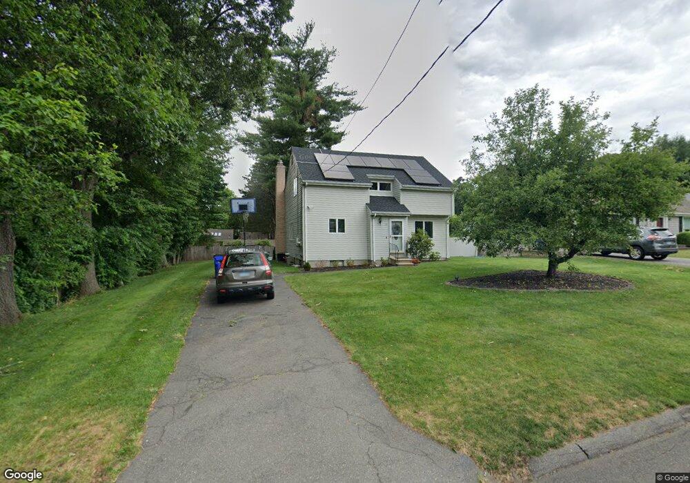
29 Cranston Ave Wethersfield, CT 06109
Estimated Value: $389,000 - $460,000
3
Beds
2
Baths
1,624
Sq Ft
$267/Sq Ft
Est. Value
About This Home
This home is located at 29 Cranston Ave, Wethersfield, CT 06109 and is currently estimated at $433,260, approximately $266 per square foot. 29 Cranston Ave is a home located in Hartford County with nearby schools including Samuel B. Webb Elementary School, Silas Deane Middle School, and Wethersfield High School.
Ownership History
Date
Name
Owned For
Owner Type
Purchase Details
Closed on
Oct 14, 2009
Sold by
Zink Stephen I and Choi Jenny J
Bought by
Eaton Michael
Current Estimated Value
Home Financials for this Owner
Home Financials are based on the most recent Mortgage that was taken out on this home.
Original Mortgage
$255,290
Interest Rate
5.14%
Create a Home Valuation Report for This Property
The Home Valuation Report is an in-depth analysis detailing your home's value as well as a comparison with similar homes in the area
Home Values in the Area
Average Home Value in this Area
Purchase History
| Date | Buyer | Sale Price | Title Company |
|---|---|---|---|
| Eaton Michael | $264,000 | -- |
Source: Public Records
Mortgage History
| Date | Status | Borrower | Loan Amount |
|---|---|---|---|
| Open | Eaton Michael | $256,695 | |
| Closed | Eaton Michael | $255,290 | |
| Previous Owner | Eaton Michael | $18,500 | |
| Previous Owner | Eaton Michael | $48,000 |
Source: Public Records
Tax History
| Year | Tax Paid | Tax Assessment Tax Assessment Total Assessment is a certain percentage of the fair market value that is determined by local assessors to be the total taxable value of land and additions on the property. | Land | Improvement |
|---|---|---|---|---|
| 2025 | $11,225 | $272,320 | $97,020 | $175,300 |
| 2024 | $7,221 | $167,070 | $65,800 | $101,270 |
| 2023 | $6,980 | $167,070 | $65,800 | $101,270 |
| 2022 | $6,863 | $167,070 | $65,800 | $101,270 |
| 2021 | $6,795 | $167,070 | $65,800 | $101,270 |
| 2020 | $6,798 | $167,070 | $65,800 | $101,270 |
| 2019 | $6,806 | $167,070 | $65,800 | $101,270 |
| 2018 | $7,002 | $171,700 | $63,300 | $108,400 |
| 2017 | $6,829 | $171,700 | $63,300 | $108,400 |
| 2016 | $6,617 | $171,700 | $63,300 | $108,400 |
| 2015 | $6,557 | $171,700 | $63,300 | $108,400 |
| 2014 | $6,308 | $171,700 | $63,300 | $108,400 |
Source: Public Records
Map
Nearby Homes
- 19 Tanner Crossing Unit 19
- 273 Forest Dr
- 47 Forest Dr
- 173 Timber Trail
- 20 Forest Dr
- 72 Concord Cir
- 7 Barrington Dr Unit C
- 104 Willow St
- 116 Wells Farm Dr
- 84 Connecticut Ave
- 79 Piper Brook Ave
- 97 Brussels Ave
- 82 Millbrook Ct
- 33 Cedar Ridge Rd
- 455 Brimfield Rd
- 19 Albert Ave
- 38 Northwood Rd
- 62 Harold Dr
- 263 Williamstown Ct
- 131 Williamstown Ct Unit 131
- 21 Cranston Ave
- 37 Cranston Ave
- 40 Pawtucket Ave
- 36 Pawtucket Ave
- 43 Cranston Ave
- 38 Cranston Ave
- 34 Cranston Ave
- 48 Pawtucket Ave
- 4 Providence St
- 10 Providence St
- 22 Cranston Ave
- 49 Cranston Ave
- 14 Providence St
- 10 Cranston Ave
- 48 Cranston Ave
- 35 Kingston St
- 60 Pawtucket Ave
- 43 Kingston St
- 50 Cranston Ave
- 31 Kingston St
Your Personal Tour Guide
Ask me questions while you tour the home.