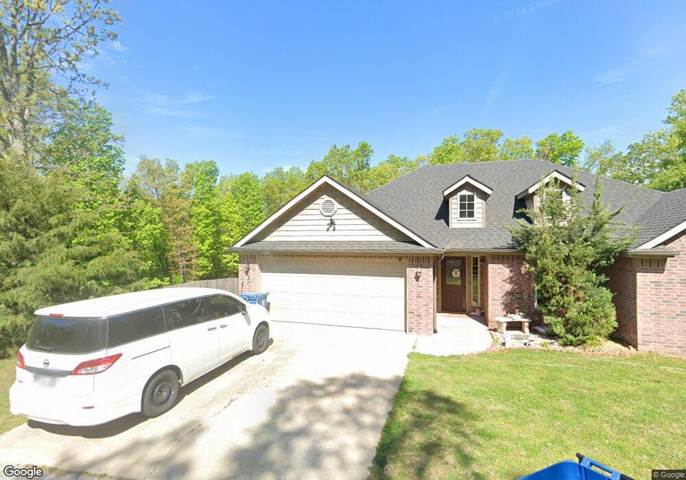
29 Dunsford Dr Bella Vista, AR 72715
Estimated Value: $325,000 - $373,000
3
Beds
2
Baths
1,617
Sq Ft
$211/Sq Ft
Est. Value
About This Home
This home is located at 29 Dunsford Dr, Bella Vista, AR 72715 and is currently estimated at $340,870, approximately $210 per square foot. 29 Dunsford Dr is a home located in Benton County with nearby schools including Thomas Jefferson Elementary School, Lincoln Junior High School, and Old High Middle School.
Ownership History
Date
Name
Owned For
Owner Type
Purchase Details
Closed on
Jul 30, 2008
Sold by
Kal Investments Llc
Bought by
Cisneros Francisco J
Current Estimated Value
Purchase Details
Closed on
Apr 10, 2008
Sold by
Russell Stephen D and Russell Geraldine
Bought by
Kal Investments Llc
Purchase Details
Closed on
Nov 23, 2004
Bought by
Russell
Purchase Details
Closed on
Feb 22, 1984
Bought by
Hanks
Create a Home Valuation Report for This Property
The Home Valuation Report is an in-depth analysis detailing your home's value as well as a comparison with similar homes in the area
Home Values in the Area
Average Home Value in this Area
Purchase History
| Date | Buyer | Sale Price | Title Company |
|---|---|---|---|
| Cisneros Francisco J | $148,000 | Lenders Title Company | |
| Kal Investments Llc | $5,000 | Lenders Title Company | |
| Russell | -- | -- | |
| Hanks | $8,000 | -- |
Source: Public Records
Tax History Compared to Growth
Tax History
| Year | Tax Paid | Tax Assessment Tax Assessment Total Assessment is a certain percentage of the fair market value that is determined by local assessors to be the total taxable value of land and additions on the property. | Land | Improvement |
|---|---|---|---|---|
| 2025 | $2,613 | $58,259 | $1,600 | $56,659 |
| 2024 | $2,474 | $58,259 | $1,600 | $56,659 |
| 2023 | $2,249 | $40,800 | $800 | $40,000 |
| 2022 | $2,143 | $40,800 | $800 | $40,000 |
| 2021 | $1,960 | $40,800 | $800 | $40,000 |
| 2020 | $1,798 | $28,230 | $600 | $27,630 |
| 2019 | $1,798 | $28,230 | $600 | $27,630 |
| 2018 | $1,798 | $28,230 | $600 | $27,630 |
| 2017 | $1,731 | $28,230 | $600 | $27,630 |
| 2016 | $1,731 | $28,230 | $600 | $27,630 |
| 2015 | $1,579 | $26,180 | $1,000 | $25,180 |
| 2014 | $1,579 | $26,180 | $1,000 | $25,180 |
Source: Public Records
Map
Nearby Homes
- TBD Dunsford Dr
- Lot 23 of Block 1 Dunsford Dr
- 30 Kensington Dr
- Lot 26 Block 2 Kensington Dr
- 13 Kensington Dr
- 4 Frensham Ln
- 55 Portsmouth Dr
- Lot 1 of Block 3 London Dr
- 0 Portsmouth Dr Unit 1319021
- 0 Chelmsworth Dr Unit 1294164
- Lot 22 Chelmsworth Dr
- 0 Chelmsworth Dr Unit 1327558
- 22 Pembroke Ln
- 2 Portland Ln
- Lot 3 of Block 3 Queensborough Dr
- 6 & 8 Gail Ln
- 18 Worstead Ln
- 14 Gretchen Ln
- 61 London Dr
- 0 Pimlico Dr
- 3101 Dunsford Dr
- 310 Dunsford Dr
- 130 Dunsford Dr
- 999 Dunsford Dr
- 4387 Dunsford Dr
- 832 Dunsford Dr
- 2306 Dunsford Dr
- 12676 Dunsford Dr
- 18 Dunsford Dr
- 3 Netherton Ln
- 27 Dunsford Dr
- 1 Netherton Ln
- 14505 Netherton Ln
- 14 Dunsford Dr
- L28 Dunsford Dr
- 2 Netherton Ln
- 2 Netherton Cir
- 25 Dunsford Dr
- 2450 Netherton Ln
- 705 Netherton Ln