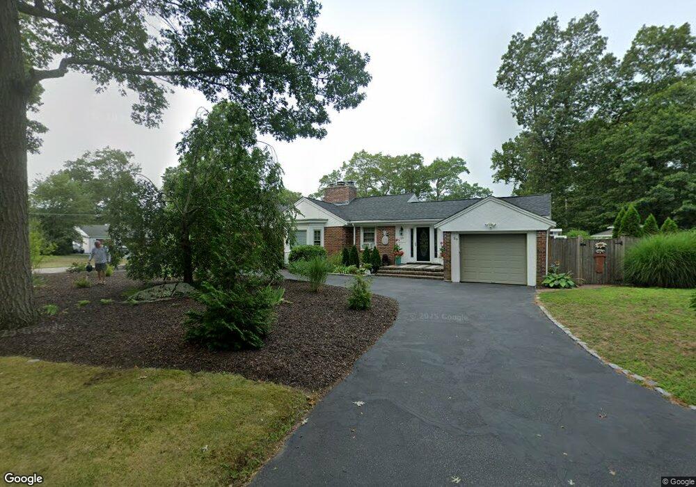
29 Fern Cir Brockton, MA 02301
Winters Corner NeighborhoodEstimated Value: $567,997 - $700,000
2
Beds
2
Baths
1,618
Sq Ft
$387/Sq Ft
Est. Value
About This Home
This home is located at 29 Fern Cir, Brockton, MA 02301 and is currently estimated at $625,499, approximately $386 per square foot. 29 Fern Cir is a home located in Plymouth County with nearby schools including Manthala George Jr. School, Hancock Elementary School, and Louis F Angelo Elementary School.
Ownership History
Date
Name
Owned For
Owner Type
Purchase Details
Closed on
Nov 26, 2003
Sold by
Fern Circle Nt Rt
Bought by
Delacono Karen M
Current Estimated Value
Home Financials for this Owner
Home Financials are based on the most recent Mortgage that was taken out on this home.
Original Mortgage
$219,000
Interest Rate
6.09%
Mortgage Type
Purchase Money Mortgage
Purchase Details
Closed on
Apr 9, 2003
Sold by
Yaitanes Philip N
Bought by
Fern Circle Nt Rt
Home Financials for this Owner
Home Financials are based on the most recent Mortgage that was taken out on this home.
Original Mortgage
$160,000
Interest Rate
5.86%
Mortgage Type
Purchase Money Mortgage
Create a Home Valuation Report for This Property
The Home Valuation Report is an in-depth analysis detailing your home's value as well as a comparison with similar homes in the area
Home Values in the Area
Average Home Value in this Area
Purchase History
| Date | Buyer | Sale Price | Title Company |
|---|---|---|---|
| Delacono Karen M | $319,000 | -- | |
| Fern Circle Nt Rt | $160,000 | -- |
Source: Public Records
Mortgage History
| Date | Status | Borrower | Loan Amount |
|---|---|---|---|
| Open | Fern Circle Nt Rt | $263,000 | |
| Closed | Fern Circle Nt Rt | $219,000 | |
| Previous Owner | Fern Circle Nt Rt | $160,000 | |
| Previous Owner | Fern Circle Nt Rt | $58,000 |
Source: Public Records
Tax History Compared to Growth
Tax History
| Year | Tax Paid | Tax Assessment Tax Assessment Total Assessment is a certain percentage of the fair market value that is determined by local assessors to be the total taxable value of land and additions on the property. | Land | Improvement |
|---|---|---|---|---|
| 2025 | $6,147 | $507,600 | $153,100 | $354,500 |
| 2024 | $6,101 | $507,600 | $153,100 | $354,500 |
| 2023 | $6,355 | $489,600 | $118,700 | $370,900 |
| 2022 | $5,376 | $384,800 | $108,100 | $276,700 |
| 2021 | $5,527 | $381,200 | $100,200 | $281,000 |
| 2020 | $5,309 | $350,400 | $95,900 | $254,500 |
| 2019 | $5,486 | $331,100 | $89,700 | $241,400 |
| 2018 | $3,603 | $301,500 | $89,700 | $211,800 |
| 2017 | $4,603 | $285,900 | $89,700 | $196,200 |
| 2016 | $4,944 | $284,800 | $86,000 | $198,800 |
| 2015 | $4,953 | $272,900 | $86,000 | $186,900 |
| 2014 | $4,989 | $275,200 | $86,000 | $189,200 |
Source: Public Records
Map
Nearby Homes
- 28 Fern Ave
- 37 West St
- 25 Monson St
- 48 N Belcher Ave
- 72 W Elm Terrace
- 161 Moraine St
- 17 Moraine Place
- 45 Briarcliff Rd
- 67 Sycamore Ave Unit 3
- 20 Montauk Rd
- 21 Oneida Ave
- 78 Keene St
- 117 Fairview Ave
- 15 Byron Ave
- 175 Belmont Ave
- 77 Colonel Bell Dr Unit 4
- 61 Fairfield St
- 190 Highland St
- 281 Spring St
- 141 Prospect Ave