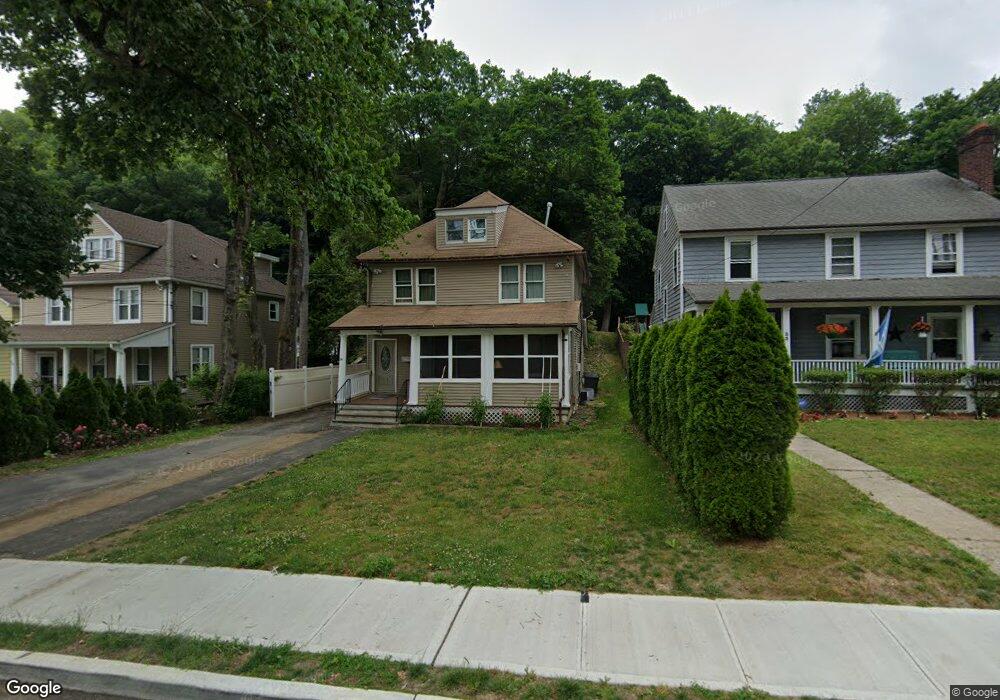
29 Grove St Mount Kisco, NY 10549
Estimated Value: $736,000 - $837,000
4
Beds
2
Baths
1,726
Sq Ft
$454/Sq Ft
Est. Value
About This Home
This home is located at 29 Grove St, Mount Kisco, NY 10549 and is currently estimated at $783,929, approximately $454 per square foot. 29 Grove St is a home located in Westchester County with nearby schools including Mount Kisco Elementary School, Fox Lane Middle School, and Fox Lane High School.
Ownership History
Date
Name
Owned For
Owner Type
Purchase Details
Closed on
Sep 28, 2019
Sold by
Arriaga Juan Francisco
Bought by
Guerra Roberto
Current Estimated Value
Purchase Details
Closed on
Sep 19, 2007
Sold by
Pietrobono Anna C
Bought by
Arriaga Juan Francisco
Home Financials for this Owner
Home Financials are based on the most recent Mortgage that was taken out on this home.
Original Mortgage
$400,000
Interest Rate
6.5%
Mortgage Type
Purchase Money Mortgage
Purchase Details
Closed on
Apr 4, 2007
Sold by
Pietrobono Rex M
Bought by
Pietrobono Anna C
Purchase Details
Closed on
Dec 12, 2003
Sold by
Barrett Mary Ellen
Bought by
Pietrobono Rex M
Home Financials for this Owner
Home Financials are based on the most recent Mortgage that was taken out on this home.
Original Mortgage
$360,000
Interest Rate
8.1%
Mortgage Type
Unknown
Create a Home Valuation Report for This Property
The Home Valuation Report is an in-depth analysis detailing your home's value as well as a comparison with similar homes in the area
Home Values in the Area
Average Home Value in this Area
Purchase History
| Date | Buyer | Sale Price | Title Company |
|---|---|---|---|
| Guerra Roberto | -- | Benchmark Title Agency Llc | |
| Arriaga Juan Francisco | $500,000 | The Judicial Title Ins Agenc | |
| Pietrobono Anna C | -- | Attorneys Title | |
| Pietrobono Rex M | $400,000 | Attorneys Title Ins Agency I |
Source: Public Records
Mortgage History
| Date | Status | Borrower | Loan Amount |
|---|---|---|---|
| Previous Owner | Arriaga Juan Francisco | $400,000 | |
| Previous Owner | Pietrobono Rex M | $360,000 |
Source: Public Records
Tax History Compared to Growth
Tax History
| Year | Tax Paid | Tax Assessment Tax Assessment Total Assessment is a certain percentage of the fair market value that is determined by local assessors to be the total taxable value of land and additions on the property. | Land | Improvement |
|---|---|---|---|---|
| 2024 | $13,455 | $61,200 | $10,000 | $51,200 |
| 2023 | $9,402 | $61,200 | $10,000 | $51,200 |
| 2022 | $15,957 | $58,700 | $10,000 | $48,700 |
| 2021 | $9,332 | $58,700 | $10,000 | $48,700 |
| 2020 | $12,221 | $58,700 | $10,000 | $48,700 |
| 2019 | $12,813 | $58,700 | $10,000 | $48,700 |
| 2018 | $6,944 | $58,700 | $10,000 | $48,700 |
| 2017 | $0 | $58,700 | $10,000 | $48,700 |
| 2016 | $7,823 | $58,700 | $10,000 | $48,700 |
| 2015 | -- | $58,700 | $10,000 | $48,700 |
| 2014 | -- | $58,700 | $10,000 | $48,700 |
| 2013 | -- | $58,700 | $10,000 | $48,700 |
Source: Public Records
Map
Nearby Homes
- 29 Carpenter Ave Unit 4A
- 47 Carpenter Ave Unit A
- 67 Carpenter Ave Unit B
- 3306 Victoria Dr
- 50 Barker St Unit 535
- 903 Kensington Way
- 25 Barker St Unit 512
- 120 Mclain St
- 35 Stewart Place Unit 204A
- 25 Stewart Place Unit 514
- 17 Mountain Ave
- 199 Grove St
- 200 Diplomat Dr Unit 8B
- 100 Diplomat Dr Unit 7A
- 100 Diplomat Dr Unit 4B
- 100 Diplomat Dr Unit 3J
- 323 E Main St
- 28 Mclain St
- 24 Penwood Rd
- 38 John Cross Rd