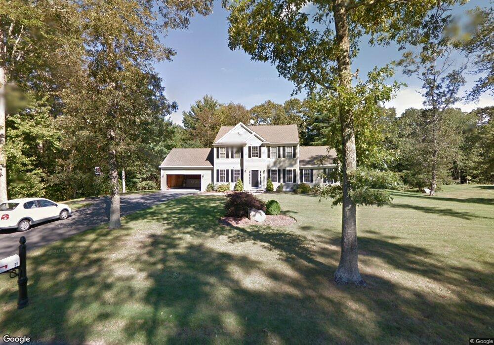
29 Lighthouse Ln Westport, MA 02790
North Westport NeighborhoodEstimated Value: $765,671 - $945,000
3
Beds
3
Baths
2,108
Sq Ft
$400/Sq Ft
Est. Value
About This Home
This home is located at 29 Lighthouse Ln, Westport, MA 02790 and is currently estimated at $843,418, approximately $400 per square foot. 29 Lighthouse Ln is a home located in Bristol County with nearby schools including Alice A. Macomber Primary School, Westport Elementary School, and Westport Middle-High School.
Ownership History
Date
Name
Owned For
Owner Type
Purchase Details
Closed on
Aug 27, 2008
Sold by
Swain Andrea L and Swain Frank R
Bought by
Camara Linda and Camara William Sean
Current Estimated Value
Home Financials for this Owner
Home Financials are based on the most recent Mortgage that was taken out on this home.
Original Mortgage
$427,764
Interest Rate
6.41%
Mortgage Type
FHA
Purchase Details
Closed on
Oct 21, 2004
Sold by
Long Built Homes Inc
Bought by
Swain Andrea L and Swain Frank R
Create a Home Valuation Report for This Property
The Home Valuation Report is an in-depth analysis detailing your home's value as well as a comparison with similar homes in the area
Home Values in the Area
Average Home Value in this Area
Purchase History
| Date | Buyer | Sale Price | Title Company |
|---|---|---|---|
| Camara Linda | $430,000 | -- | |
| Swain Andrea L | $441,025 | -- |
Source: Public Records
Mortgage History
| Date | Status | Borrower | Loan Amount |
|---|---|---|---|
| Open | Swain Andrea L | $431,471 | |
| Closed | Swain Andrea L | $430,079 | |
| Closed | Swain Andrea L | $427,764 |
Source: Public Records
Tax History
| Year | Tax Paid | Tax Assessment Tax Assessment Total Assessment is a certain percentage of the fair market value that is determined by local assessors to be the total taxable value of land and additions on the property. | Land | Improvement |
|---|---|---|---|---|
| 2025 | $4,851 | $651,200 | $210,400 | $440,800 |
| 2024 | $4,732 | $612,200 | $195,000 | $417,200 |
| 2023 | $4,282 | $524,800 | $185,700 | $339,100 |
| 2022 | $4,118 | $485,600 | $185,700 | $299,900 |
| 2021 | $4,040 | $468,700 | $168,800 | $299,900 |
| 2020 | $3,895 | $462,000 | $162,100 | $299,900 |
| 2019 | $3,791 | $458,400 | $162,100 | $296,300 |
| 2018 | $3,430 | $419,800 | $130,100 | $289,700 |
| 2017 | $3,371 | $423,000 | $132,600 | $290,400 |
| 2016 | $3,141 | $397,100 | $137,600 | $259,500 |
| 2015 | $3,011 | $379,700 | $140,100 | $239,600 |
Source: Public Records
Map
Nearby Homes
- 45 Greenfield Rd
- 24 Greenfield Rd
- 218 American Legion Hwy
- 47 Devol Ave
- 2 Magnolia Ln
- 33 Moniz Dr
- 40 Sycamore Ln
- 329 Tickle Rd
- 259 Tickle Rd
- 771 Sanford Rd
- 0 Tickle Rd Unit 73453134
- 6 Angel Ct
- 179 Robert St
- 47 Robert St
- 100 Corys Ln
- 85 Watuppa Rd
- 105 Florence St
- 8 Campion Ave
- 214 Sawdy Dr
- 1023 Old Stafford Rd
- 25 Lighthouse Ln
- 33 Lighthouse Ln
- 26 Lighthouse Ln
- 30 Lighthouse Ln
- 22 Lighthouse Ln
- 21 Lighthouse Ln
- 34 Lighthouse Ln
- 37 Lighthouse Ln
- 18 Lighthouse Ln
- 49 Spinnaker Way
- 17 Lighthouse Ln
- 37 Spinnaker Way
- 38 Lighthouse Ln
- 41 Spinnaker Way
- 14 Lighthouse Ln
- 56 Meadow Rd
- 55 Spinnaker Way
- 60 Meadow Rd
- 41 Lighthouse Ln
- 33 Spinnaker Way
Your Personal Tour Guide
Ask me questions while you tour the home.