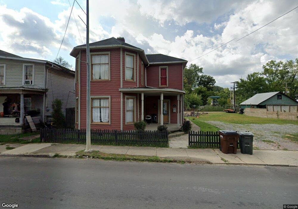
29 Main St Glouster, OH 45732
Estimated Value: $113,000 - $188,000
3
Beds
2
Baths
1,800
Sq Ft
$84/Sq Ft
Est. Value
About This Home
This home is located at 29 Main St, Glouster, OH 45732 and is currently estimated at $150,682, approximately $83 per square foot. 29 Main St is a home located in Athens County with nearby schools including Trimble Elementary School, Trimble Middle School, and Trimble High School.
Ownership History
Date
Name
Owned For
Owner Type
Purchase Details
Closed on
Jul 28, 2023
Sold by
Moody Rickey Lee and Moody Jose Luis
Bought by
Dixon Michael and Dixon Tabitha
Current Estimated Value
Home Financials for this Owner
Home Financials are based on the most recent Mortgage that was taken out on this home.
Original Mortgage
$99,400
Outstanding Balance
$96,441
Interest Rate
6.81%
Mortgage Type
New Conventional
Estimated Equity
$54,241
Purchase Details
Closed on
May 8, 2020
Sold by
Athens County Land Reutilization Corp
Bought by
Moody Rickey Lee and Cortes Jose Luis
Purchase Details
Closed on
May 16, 2019
Sold by
Hook Joel J and Hook Christy L
Bought by
Athens County Land Reutilization Corp
Purchase Details
Closed on
Oct 13, 1999
Sold by
Buchanan Gloria
Bought by
Hook Joel J and Hook Christy L
Purchase Details
Closed on
Feb 26, 1999
Bought by
Buchanan Gloria
Purchase Details
Closed on
Jul 17, 1998
Sold by
Limo Terese
Bought by
The Glouster Community Bank
Create a Home Valuation Report for This Property
The Home Valuation Report is an in-depth analysis detailing your home's value as well as a comparison with similar homes in the area
Purchase History
We collect this data history from publicly available records. To have your information removed, we recommend requesting removal directly through your county’s website.
| Date | Buyer | Sale Price | Title Company |
|---|---|---|---|
| Dixon Michael | $130,000 | None Listed On Document | |
| Moody Rickey Lee | -- | None Available | |
| Athens County Land Reutilization Corp | -- | None Available | |
| Hook Joel J | $46,000 | -- | |
| Buchanan Gloria | $12,000 | -- | |
| The Glouster Community Bank | -- | -- |
Source: Public Records
Mortgage History
We collect this data history from publicly available records. To have your information removed, we recommend requesting removal directly through your county’s website.
| Date | Status | Borrower | Loan Amount |
|---|---|---|---|
| Open | Dixon Michael | $99,400 |
Source: Public Records
Tax History
| Year | Tax Paid | Tax Assessment Tax Assessment Total Assessment is a certain percentage of the fair market value that is determined by local assessors to be the total taxable value of land and additions on the property. | Land | Improvement |
|---|---|---|---|---|
| 2025 | $2,169 | $43,820 | $1,450 | $42,370 |
| 2024 | $2,483 | $43,820 | $1,450 | $42,370 |
| 2023 | $1,706 | $24,190 | $1,450 | $22,740 |
| 2022 | $1,343 | $20,470 | $1,450 | $19,020 |
| 2021 | $328 | $6,210 | $1,450 | $4,760 |
| 2020 | $0 | $6,210 | $1,450 | $4,760 |
| 2019 | $0 | $5,680 | $1,290 | $4,390 |
| 2018 | $331 | $5,680 | $1,290 | $4,390 |
| 2017 | $487 | $5,680 | $1,290 | $4,390 |
| 2016 | $322 | $5,360 | $1,290 | $4,070 |
| 2015 | $1,819 | $5,360 | $1,290 | $4,070 |
| 2014 | $1,819 | $17,580 | $1,290 | $16,290 |
| 2013 | $2,262 | $18,180 | $1,230 | $16,950 |
Source: Public Records
Map
Nearby Homes
Your Personal Tour Guide
Ask me questions while you tour the home.