
Seller's Agent in 2025
Krystal Holmes
Chestnut Oak Associates
(860) 490-1460
11 in this area
24 Total Sales
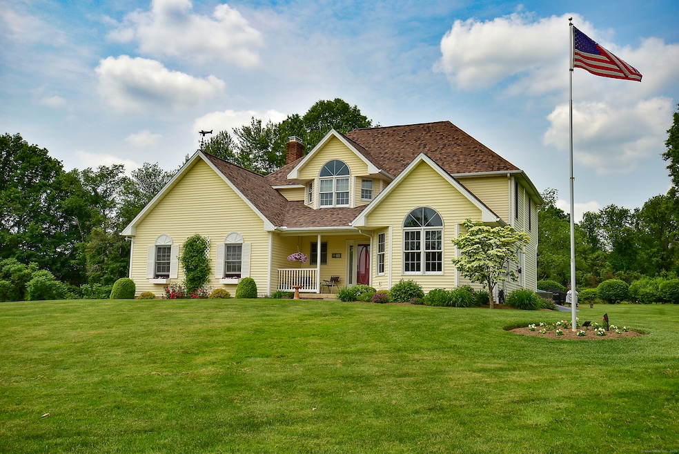
Welcome to this immaculately maintained, original owner, colonial offering 2,300+ sq ft of inviting living space w/ 4 bedrooms, 2.5 baths. Set on a meticulously landscaped lot within a cul-de-sac neighborhood, this home features a stunning backyard oasis complete w/ a spacious deck & sparkling in-ground pool surrounded by classic pavers featuring a fire pit and sitting wall - perfect for summer entertaining. Step inside to discover an open layout filled with abundant natural light w/ a seamless flow between living, dining, & kitchen spaces, ideal for entertaining. The eat-in kitchen features beautiful white cabinetry, granite tops, newer stainless-steel appliances and hardwood floors. The bright & spacious sunroom with vaulted ceiling & exposed beams is ideal for relaxing year-round. Recent upgrades include a new boiler and roof (2021), new central A/C (2022), new bedroom carpets (2021), new pool pavers & expanded deck (2022) - giving you peace of mind. Lovingly cared for and thoughtfully updated, this home combines comfort, function, and style both inside & out-don't miss your chance to make it yours!
Last Agent to Sell the Property
Chestnut Oak Associates License #RES.0764393 Listed on: 06/18/2025
| Date | Type | Sale Price | Title Company |
|---|---|---|---|
| Warranty Deed | $676,000 | -- | |
| Deed | $224,900 | -- | |
| Deed | $224,900 | -- |
| Date | Status | Loan Amount | Loan Type |
|---|---|---|---|
| Open | $608,400 | Future Advance Clause Open End Mortgage | |
| Previous Owner | $125,000 | Purchase Money Mortgage |
| Date | Event | Price | List to Sale | Price per Sq Ft |
|---|---|---|---|---|
| 07/31/2025 07/31/25 | Sold | $676,000 | +12.7% | $282 / Sq Ft |
| 06/23/2025 06/23/25 | Pending | -- | -- | -- |
| 06/19/2025 06/19/25 | For Sale | $599,900 | -- | $250 / Sq Ft |
| Year | Tax Paid | Tax Assessment Tax Assessment Total Assessment is a certain percentage of the fair market value that is determined by local assessors to be the total taxable value of land and additions on the property. | Land | Improvement |
|---|---|---|---|---|
| 2025 | $7,494 | $320,110 | $66,430 | $253,680 |
| 2024 | $7,244 | $320,110 | $66,430 | $253,680 |
| 2023 | $7,186 | $251,160 | $66,430 | $184,730 |
| 2022 | $7,166 | $250,460 | $66,430 | $184,030 |
| 2021 | $7,173 | $250,460 | $66,430 | $184,030 |
| 2020 | $7,173 | $250,460 | $66,430 | $184,030 |
| 2019 | $7,193 | $250,460 | $66,430 | $184,030 |
| 2018 | $7,495 | $255,640 | $65,380 | $190,260 |
| 2017 | $7,385 | $255,640 | $65,380 | $190,260 |
| 2016 | $7,209 | $255,640 | $65,380 | $190,260 |
| 2015 | $7,102 | $255,640 | $65,380 | $190,260 |
| 2014 | $6,933 | $255,640 | $65,380 | $190,260 |
Seller's Agent in 2025
Krystal Holmes
Chestnut Oak Associates
(860) 490-1460
11 in this area
24 Total Sales
Buyer's Agent in 2025
Suzanne Walsh
William Raveis Real Estate
(860) 306-1927
2 in this area
58 Total Sales
Source: SmartMLS
MLS Number: 24104659
APN: SUFF-000068H-000047-000113I
Disclaimer: Certain information contained herein is derived from information provided by parties other than Homes.com. All information provided is deemed reliable, but is not guaranteed to be accurate and should be independently verified.
![]() IDX information is provided exclusively for personal, non-commercial use, and may not be used for any purpose other than to identify prospective properties consumers may be interested in purchasing. Information is deemed reliable but not guaranteed.
IDX information is provided exclusively for personal, non-commercial use, and may not be used for any purpose other than to identify prospective properties consumers may be interested in purchasing. Information is deemed reliable but not guaranteed.
Ask me questions while you tour the home.