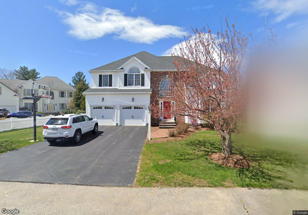
29 Muir Way Marlborough, MA 01752
Estimated Value: $854,000 - $966,000
4
Beds
3
Baths
2,645
Sq Ft
$348/Sq Ft
Est. Value
About This Home
This home is located at 29 Muir Way, Marlborough, MA 01752 and is currently estimated at $919,592, approximately $347 per square foot. 29 Muir Way is a home located in Middlesex County with nearby schools including Marlborough High School, New Covenant Christian School, and Glenhaven Academy - JRI School.
Ownership History
Date
Name
Owned For
Owner Type
Purchase Details
Closed on
Apr 18, 2001
Sold by
Forest Grove Rt and Terrill Richard E
Bought by
Kotsiras George and Kotsiras Kimberly J
Current Estimated Value
Home Financials for this Owner
Home Financials are based on the most recent Mortgage that was taken out on this home.
Original Mortgage
$210,500
Interest Rate
6.9%
Mortgage Type
Purchase Money Mortgage
Create a Home Valuation Report for This Property
The Home Valuation Report is an in-depth analysis detailing your home's value as well as a comparison with similar homes in the area
Home Values in the Area
Average Home Value in this Area
Purchase History
| Date | Buyer | Sale Price | Title Company |
|---|---|---|---|
| Kotsiras George | $368,310 | -- |
Source: Public Records
Mortgage History
| Date | Status | Borrower | Loan Amount |
|---|---|---|---|
| Open | Kotsiras George | $232,000 | |
| Closed | Kotsiras George | $210,500 |
Source: Public Records
Tax History Compared to Growth
Tax History
| Year | Tax Paid | Tax Assessment Tax Assessment Total Assessment is a certain percentage of the fair market value that is determined by local assessors to be the total taxable value of land and additions on the property. | Land | Improvement |
|---|---|---|---|---|
| 2025 | $8,454 | $857,400 | $257,000 | $600,400 |
| 2024 | $8,109 | $791,900 | $233,600 | $558,300 |
| 2023 | $8,128 | $704,300 | $194,400 | $509,900 |
| 2022 | $7,838 | $597,400 | $185,100 | $412,300 |
| 2021 | $7,699 | $557,900 | $157,100 | $400,800 |
| 2020 | $7,486 | $527,900 | $144,300 | $383,600 |
| 2019 | $7,225 | $513,500 | $141,400 | $372,100 |
| 2018 | $7,232 | $494,300 | $121,500 | $372,800 |
| 2017 | $7,180 | $468,700 | $118,700 | $350,000 |
| 2016 | $7,018 | $457,500 | $118,700 | $338,800 |
| 2015 | $6,997 | $444,000 | $111,500 | $332,500 |
Source: Public Records
Map
Nearby Homes
- 109 Westminster Dr Unit 109
- 608 Boston Post Rd E Unit 11
- 596 Boston Post Rd E
- 596 Boston Post Rd E Unit 13
- 624 Boston Post Rd E Unit 7
- 114 Linda Cir
- 23 Victoria Ln
- 2 Ethel Ave
- 271 Boston Post Rd E Unit 4
- 10 Eldorado Dr
- 688 Boston Post Rd E Unit 202
- 688 Boston Post Rd E Unit 100
- 688 Boston Post Rd E Unit 304
- 688 Boston Post Rd E Unit 324
- 688 Boston Post Rd E Unit 228
- 32 Ethel
- 13 Vals Ln
- 16 Holly Hill Ln
- 3 Garabed Blvd
- 552 Farm Rd
- 23 Muir Way
- 35 Muir Way
- 39 Muir Way
- 17 Muir Way
- 123 Westminster Dr
- 121 Westminster Dr
- 119 Westminster Dr
- 117 Westminster Dr
- 115 Westminster Dr
- 113 Westminster Dr
- 115 Westminster Dr Unit 54
- 121 Westminster Dr Unit 57
- 109 Westminster Dr
- 107 Westminster Dr
- 105 Westminster Dr
- 103 Westminster Dr
- 101 Westminster Dr
- 99 Westminster Dr
- 109 Westminster Dr Unit 48
- 105 Westminster Dr Unit 46-10