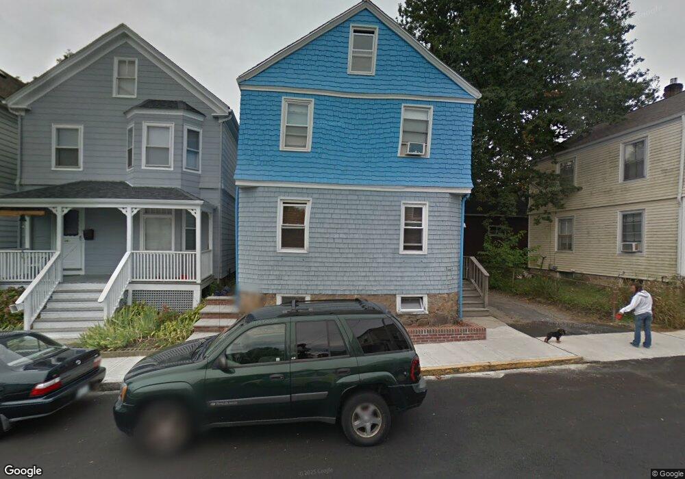
29 Newport Ave Newport, RI 02840
Estimated Value: $677,000 - $780,835
4
Beds
2
Baths
1,366
Sq Ft
$548/Sq Ft
Est. Value
About This Home
This home is located at 29 Newport Ave, Newport, RI 02840 and is currently estimated at $749,209, approximately $548 per square foot. 29 Newport Ave is a home located in Newport County with nearby schools including Rogers High School, St Michael's Country Day School, and St George's School.
Ownership History
Date
Name
Owned For
Owner Type
Purchase Details
Closed on
Jun 1, 2009
Sold by
Countrywide Home Loans
Bought by
Mather Timothy S and Thompson Sarah
Current Estimated Value
Purchase Details
Closed on
Aug 21, 2008
Sold by
Cayce Valerie and Cayce Byron
Bought by
Ocean Bank Fsb
Create a Home Valuation Report for This Property
The Home Valuation Report is an in-depth analysis detailing your home's value as well as a comparison with similar homes in the area
Home Values in the Area
Average Home Value in this Area
Purchase History
| Date | Buyer | Sale Price | Title Company |
|---|---|---|---|
| Mather Timothy S | $144,000 | -- | |
| Ocean Bank Fsb | $212,000 | -- |
Source: Public Records
Mortgage History
| Date | Status | Borrower | Loan Amount |
|---|---|---|---|
| Open | Ocean Bank Fsb | $187,500 | |
| Closed | Ocean Bank Fsb | $199,401 |
Source: Public Records
Tax History Compared to Growth
Tax History
| Year | Tax Paid | Tax Assessment Tax Assessment Total Assessment is a certain percentage of the fair market value that is determined by local assessors to be the total taxable value of land and additions on the property. | Land | Improvement |
|---|---|---|---|---|
| 2025 | $4,100 | $571,100 | $132,700 | $438,400 |
| 2024 | $3,981 | $571,100 | $132,700 | $438,400 |
| 2023 | $3,877 | $390,800 | $101,600 | $289,200 |
| 2022 | $3,756 | $390,800 | $101,600 | $289,200 |
| 2021 | $3,646 | $390,800 | $101,600 | $289,200 |
| 2020 | $3,015 | $293,300 | $95,600 | $197,700 |
| 2019 | $3,015 | $293,300 | $95,600 | $197,700 |
| 2018 | $2,930 | $293,300 | $95,600 | $197,700 |
| 2017 | $2,876 | $256,600 | $73,500 | $183,100 |
| 2016 | $2,805 | $256,600 | $73,500 | $183,100 |
| 2015 | $2,738 | $256,600 | $73,500 | $183,100 |
| 2014 | $2,937 | $243,500 | $54,200 | $189,300 |
Source: Public Records
Map
Nearby Homes
- 125 Van Zandt Ave Unit 307
- 4 Newport Ave Unit B2
- 3 Vicksburg Place
- 53 Warner St
- 155 Evarts St
- 44 Warner St
- 5 Bowser Ct
- 1 Arnold Ave
- 7 Sheffield Ave
- 17 Lincoln St
- 26 Prescott Hall Rd
- 17 Warner St
- 102 Broadway Unit 2B
- 19 Princeton St Unit 21
- 6 Sunshine Ct
- 27 Soar Way
- 23 Mann Ave Unit 4
- 5 Elliot Place
- 12 Poplar St
- 78 Rhode Island Ave Unit 6
- 29 1/2 Newport Ave
- 27 Newport Ave
- 31 Newport Ave
- 10 Dartmouth St
- 30 Newport Ave
- 36 Newport Ave
- 32 Newport Ave
- 25 Newport Ave
- 25 Newport Ave Unit 1
- 25 Newport Ave Unit 2
- 28 Newport Ave
- 28 Newport Ave Unit 1
- 28 Newport Ave Unit 2
- 1 Dodge Ct
- 33 Newport Ave
- 33 Newport Ave Unit 3
- 33 Newport Ave Unit 1
- 12 Dartmouth St
- 4 Nicol Terrace
- 26 Newport Ave