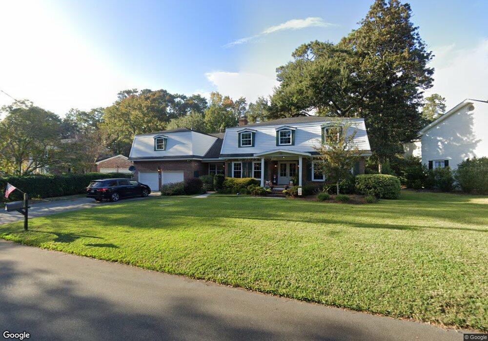
29 Nuffield Rd Charleston, SC 29407
Sandhurst NeighborhoodEstimated Value: $746,000 - $1,250,000
4
Beds
4
Baths
3,800
Sq Ft
$268/Sq Ft
Est. Value
About This Home
This home is located at 29 Nuffield Rd, Charleston, SC 29407 and is currently estimated at $1,017,408, approximately $267 per square foot. 29 Nuffield Rd is a home located in Charleston County with nearby schools including Springfield Elementary School, West Ashley High School, and Orange Grove Elementary Charter School.
Ownership History
Date
Name
Owned For
Owner Type
Purchase Details
Closed on
Aug 25, 2014
Sold by
Charlton Kimberly R
Bought by
Patrick Paul D and Patrick Laura K
Current Estimated Value
Home Financials for this Owner
Home Financials are based on the most recent Mortgage that was taken out on this home.
Original Mortgage
$276,250
Outstanding Balance
$211,878
Interest Rate
4.19%
Mortgage Type
New Conventional
Estimated Equity
$805,530
Purchase Details
Closed on
Mar 14, 2006
Sold by
Breland Royce
Bought by
Charlton Kimberly R
Purchase Details
Closed on
Jul 9, 2003
Sold by
Hudson Albert W
Bought by
Breland Royce and Hudson Family Trust
Create a Home Valuation Report for This Property
The Home Valuation Report is an in-depth analysis detailing your home's value as well as a comparison with similar homes in the area
Home Values in the Area
Average Home Value in this Area
Purchase History
| Date | Buyer | Sale Price | Title Company |
|---|---|---|---|
| Patrick Paul D | $325,000 | -- | |
| Charlton Kimberly R | -- | None Available | |
| Charlton Kimberly R | -- | None Available | |
| Breland Royce | -- | -- |
Source: Public Records
Mortgage History
| Date | Status | Borrower | Loan Amount |
|---|---|---|---|
| Open | Patrick Paul D | $276,250 |
Source: Public Records
Tax History Compared to Growth
Tax History
| Year | Tax Paid | Tax Assessment Tax Assessment Total Assessment is a certain percentage of the fair market value that is determined by local assessors to be the total taxable value of land and additions on the property. | Land | Improvement |
|---|---|---|---|---|
| 2024 | $2,686 | $18,250 | $0 | $0 |
| 2023 | $2,402 | $18,250 | $0 | $0 |
| 2022 | $2,237 | $18,250 | $0 | $0 |
| 2021 | $2,347 | $18,250 | $0 | $0 |
| 2020 | $2,305 | $17,250 | $0 | $0 |
| 2019 | $2,051 | $15,000 | $0 | $0 |
| 2017 | $1,980 | $15,000 | $0 | $0 |
| 2016 | $1,898 | $15,000 | $0 | $0 |
| 2015 | $1,961 | $15,000 | $0 | $0 |
| 2014 | $1,955 | $0 | $0 | $0 |
| 2011 | -- | $0 | $0 | $0 |
Source: Public Records
Map
Nearby Homes
- 1220 Orange Branch Rd
- 21 Manchester Rd
- 1891 Rugby Ln
- 1376 Orange Grove Rd
- 1414 Orange Grove Rd
- 1134 Mim Ave
- 1750 Afton Ave
- 1438 Joy Ave
- 1223 Charlestowne Dr
- 1422 Alden Dr
- 1720 Somerset Cir
- 1285 Camerton St
- 1472 Orange Grove Rd
- 1711 Orange Grove Shores Dr
- 1009 Southgate Dr
- 22 River Reach Way
- 1516 N Avalon Cir
- 1522 N Avalon Cir
- 1530 Orange Grove Rd Unit A&B
- 1532 Orange Grove Rd Unit A&B
- 33 Nuffield Rd
- 21 Nuffield Rd
- 55 Shrewsbury Rd
- 24 Nuffield Rd
- 9 Nuffield Rd
- 30 Nuffield Rd
- 10 Sussex Rd
- 14 Nuffield Rd
- 64 Shrewsbury Rd
- 52 Shrewsbury Rd
- 42 Edinburgh Rd
- 63 Shrewsbury Rd
- 35 Shrewsbury Rd
- 5 Nuffield Rd
- 60 Manchester Rd
- 48 Shrewsbury Rd
- 14 Sussex Rd
- 37 Edinburgh Rd
- 2 Nuffield Rd
- 71 Shrewsbury Rd