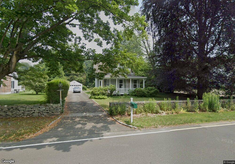
29 Rings End Rd Darien, CT 06820
Estimated Value: $1,871,000 - $2,477,000
4
Beds
3
Baths
2,291
Sq Ft
$900/Sq Ft
Est. Value
About This Home
This home is located at 29 Rings End Rd, Darien, CT 06820 and is currently estimated at $2,061,769, approximately $899 per square foot. 29 Rings End Rd is a home located in Fairfield County with nearby schools including Hindley Elementary School, Middlesex Middle School, and Darien High School.
Ownership History
Date
Name
Owned For
Owner Type
Purchase Details
Closed on
Aug 20, 2007
Sold by
Lively Sarah
Bought by
Raasch Gerald L and Raasch Barbara J
Current Estimated Value
Purchase Details
Closed on
Jun 20, 2000
Sold by
Nanula Ft and Nanula Richard D
Bought by
Cagrinelli Sarah
Purchase Details
Closed on
Sep 11, 1998
Sold by
Jennings W Bryan and Jennings Kathleen G
Bought by
Nanula Richard D and Nanula Tracey L
Purchase Details
Closed on
Dec 13, 1996
Sold by
Colon Deborah M
Bought by
Jennings W Bryan and Jennings Kathleen G
Purchase Details
Closed on
Jun 3, 1991
Sold by
Hugens Peter and Hugens Mary
Bought by
Colon John and Colon Deborah
Create a Home Valuation Report for This Property
The Home Valuation Report is an in-depth analysis detailing your home's value as well as a comparison with similar homes in the area
Home Values in the Area
Average Home Value in this Area
Purchase History
| Date | Buyer | Sale Price | Title Company |
|---|---|---|---|
| Raasch Gerald L | $1,525,000 | -- | |
| Cagrinelli Sarah | $865,000 | -- | |
| Nanula Richard D | $755,000 | -- | |
| Jennings W Bryan | $655,000 | -- | |
| Colon John | $462,500 | -- |
Source: Public Records
Mortgage History
| Date | Status | Borrower | Loan Amount |
|---|---|---|---|
| Closed | Colon John | $477,500 | |
| Closed | Colon John | $610,000 |
Source: Public Records
Tax History Compared to Growth
Tax History
| Year | Tax Paid | Tax Assessment Tax Assessment Total Assessment is a certain percentage of the fair market value that is determined by local assessors to be the total taxable value of land and additions on the property. | Land | Improvement |
|---|---|---|---|---|
| 2025 | $15,507 | $1,001,770 | $742,280 | $259,490 |
| 2024 | $14,716 | $1,001,770 | $742,280 | $259,490 |
| 2023 | $13,164 | $747,530 | $549,850 | $197,680 |
| 2022 | $12,880 | $747,530 | $549,850 | $197,680 |
| 2021 | $12,588 | $747,530 | $549,850 | $197,680 |
| 2020 | $12,230 | $747,530 | $549,850 | $197,680 |
| 2019 | $12,312 | $747,530 | $549,850 | $197,680 |
| 2018 | $15,252 | $948,500 | $693,350 | $255,150 |
| 2017 | $15,478 | $957,810 | $702,660 | $255,150 |
| 2016 | $15,105 | $957,810 | $702,660 | $255,150 |
| 2015 | $14,702 | $957,810 | $702,660 | $255,150 |
| 2014 | $14,377 | $957,810 | $702,660 | $255,150 |
Source: Public Records
Map
Nearby Homes
- 53 Noroton Ave
- 92 Pear Tree Point Rd
- 88 Pear Tree Point Rd
- 45 Hecker Ave
- 77 Maple St
- 5 Shipway Rd
- 17 Brushy Hill Rd
- 5 Mayflower Rd
- 47 Hollow Tree Ridge Rd
- 166 Hollow Tree Ridge Rd
- 51 Hale Ln Unit 51
- 130 West Ave
- 128 West Ave
- 333 West Ave Unit 3
- 105 Houston Terrace
- 28 Aquila Rd
- 120 Webb Ave
- 16 Houston Terrace Unit 7
- 20 Locust Hill Rd
- 16 Neponsit St