Estimated Value: $560,281 - $614,000
4
Beds
2
Baths
1,620
Sq Ft
$369/Sq Ft
Est. Value
About This Home
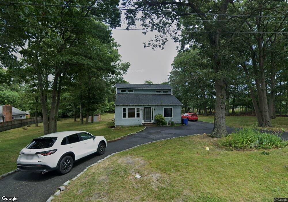
This home is located at 29 Shady Ln, Coram, NY 11727 and is currently estimated at $597,320, approximately $368 per square foot. 29 Shady Ln is a home located in Suffolk County with nearby schools including Longwood Middle School, Longwood Junior High School, and Longwood Senior High School.
Ownership History
Date
Name
Owned For
Owner Type
Purchase Details
Closed on
Dec 16, 2003
Sold by
Marrero Juan F
Bought by
Batista Rosa
Current Estimated Value
Purchase Details
Closed on
Apr 9, 2003
Sold by
Surace Patrick T and Surace Audrey R
Bought by
Marrero Juan F
Home Financials for this Owner
Home Financials are based on the most recent Mortgage that was taken out on this home.
Original Mortgage
$242,991
Interest Rate
5.64%
Mortgage Type
FHA
Purchase Details
Closed on
Oct 27, 1999
Sold by
Our Savior Church Housing Inc
Bought by
Surace Patrick T and Hamuka Audrey R
Home Financials for this Owner
Home Financials are based on the most recent Mortgage that was taken out on this home.
Original Mortgage
$100,000
Interest Rate
7.76%
Mortgage Type
Purchase Money Mortgage
Purchase Details
Closed on
Feb 26, 1999
Sold by
M & T Mtg Corp
Bought by
Hud
Purchase Details
Closed on
Jun 30, 1998
Sold by
Davidow Wallace
Bought by
M & T Mtg Corp
Create a Home Valuation Report for This Property
The Home Valuation Report is an in-depth analysis detailing your home's value as well as a comparison with similar homes in the area
Home Values in the Area
Average Home Value in this Area
Purchase History
| Date | Buyer | Sale Price | Title Company |
|---|---|---|---|
| Batista Rosa | $315,000 | -- | |
| Marrero Juan F | $252,000 | Stewart Title | |
| Surace Patrick T | $134,000 | First American Title Ins Co | |
| Hud | -- | Commonwealth Land Title Ins | |
| M & T Mtg Corp | $145,000 | Commonwealth Land Title Ins |
Source: Public Records
Mortgage History
| Date | Status | Borrower | Loan Amount |
|---|---|---|---|
| Previous Owner | Marrero Juan F | $242,991 | |
| Previous Owner | Surace Patrick T | $100,000 |
Source: Public Records
Tax History
| Year | Tax Paid | Tax Assessment Tax Assessment Total Assessment is a certain percentage of the fair market value that is determined by local assessors to be the total taxable value of land and additions on the property. | Land | Improvement |
|---|---|---|---|---|
| 2024 | $10,962 | $2,400 | $300 | $2,100 |
| 2023 | $10,962 | $2,400 | $300 | $2,100 |
| 2022 | $9,956 | $2,400 | $300 | $2,100 |
| 2021 | $9,956 | $2,400 | $300 | $2,100 |
| 2020 | $10,183 | $2,400 | $300 | $2,100 |
| 2019 | $10,183 | $0 | $0 | $0 |
| 2018 | $9,710 | $2,400 | $300 | $2,100 |
| 2017 | $9,710 | $2,400 | $300 | $2,100 |
| 2016 | $9,589 | $2,400 | $300 | $2,100 |
| 2015 | -- | $2,665 | $300 | $2,365 |
| 2014 | -- | $2,665 | $300 | $2,365 |
Source: Public Records
Map
Nearby Homes
- 37 Willow Cir Unit 37
- 175 Birchwood Rd
- 154 Birchwood Rd
- lot 26 Route 112
- 217 Birchwood Rd
- 225 Birchwood Rd Unit 669
- 239 Birchwood Rd
- 342 Clubhouse Ct
- 392 Clubhouse Ct
- 312 Clubhouse Ct
- 852 Skyline Dr
- 172 Skyline Dr
- 1016 Skyline Dr
- 980 Skyline Dr
- 964 Skyline Dr
- 11 Macintosh Ln
- 4 Macintosh Ln
- 2 Dogwood Ct Unit 2
- 5 Dogwood Ct Unit 5
- 9 Willow Ct Unit 9
Your Personal Tour Guide
Ask me questions while you tour the home.