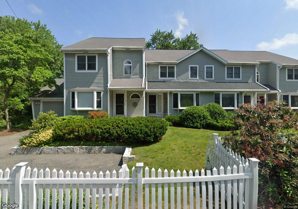
29 Spring St Unit 6 Saugus, MA 01906
North Saugus NeighborhoodEstimated Value: $469,000 - $556,000
3
Beds
3
Baths
1,780
Sq Ft
$285/Sq Ft
Est. Value
About This Home
This home is located at 29 Spring St Unit 6, Saugus, MA 01906 and is currently estimated at $507,520, approximately $285 per square foot. 29 Spring St Unit 6 is a home located in Essex County with nearby schools including Saugus High School, Pioneer Charter School Of Science II, and Our Lady Of Assumption School.
Ownership History
Date
Name
Owned For
Owner Type
Purchase Details
Closed on
Jan 14, 2019
Sold by
Carroll Ann M
Bought by
Ann M Carroll Irt
Current Estimated Value
Purchase Details
Closed on
Sep 29, 2006
Sold by
Gay Richard and Gay Sandra L
Bought by
Carroll Ann M
Purchase Details
Closed on
Jun 28, 2002
Sold by
Lee Robert M
Bought by
Gay Richard and Gay Sandra L
Purchase Details
Closed on
Jun 11, 1998
Sold by
Koizumi Maryjo
Bought by
Lee Robert M
Purchase Details
Closed on
Jul 24, 1996
Sold by
Trigilio Steven
Bought by
Koizumi Mary Jo
Purchase Details
Closed on
Dec 31, 1992
Sold by
Brooke Rt
Bought by
Trigilio Steven
Purchase Details
Closed on
Jul 25, 1988
Sold by
Spring St Rlty Tr
Bought by
Depaolo Robert L
Create a Home Valuation Report for This Property
The Home Valuation Report is an in-depth analysis detailing your home's value as well as a comparison with similar homes in the area
Home Values in the Area
Average Home Value in this Area
Purchase History
| Date | Buyer | Sale Price | Title Company |
|---|---|---|---|
| Ann M Carroll Irt | -- | -- | |
| Carroll Ann M | $326,900 | -- | |
| Gay Richard | $280,000 | -- | |
| Lee Robert M | $168,000 | -- | |
| Koizumi Mary Jo | $133,300 | -- | |
| Trigilio Steven | $128,000 | -- | |
| Depaolo Robert L | $240,000 | -- |
Source: Public Records
Mortgage History
| Date | Status | Borrower | Loan Amount |
|---|---|---|---|
| Previous Owner | Depaolo Robert L | $150,000 | |
| Previous Owner | Depaolo Robert L | $15,000 |
Source: Public Records
Tax History
| Year | Tax Paid | Tax Assessment Tax Assessment Total Assessment is a certain percentage of the fair market value that is determined by local assessors to be the total taxable value of land and additions on the property. | Land | Improvement |
|---|---|---|---|---|
| 2025 | $3,835 | $359,100 | $0 | $359,100 |
| 2024 | $3,706 | $348,000 | $0 | $348,000 |
| 2023 | $3,702 | $328,800 | $0 | $328,800 |
| 2022 | $3,776 | $314,400 | $0 | $314,400 |
| 2021 | $3,880 | $314,400 | $0 | $314,400 |
| 2020 | $3,748 | $314,400 | $0 | $314,400 |
| 2019 | $3,829 | $314,400 | $0 | $314,400 |
| 2018 | $3,483 | $300,800 | $0 | $300,800 |
| 2017 | $3,220 | $267,200 | $0 | $267,200 |
| 2016 | $3,199 | $262,200 | $0 | $262,200 |
| 2015 | $3,152 | $262,200 | $0 | $262,200 |
| 2014 | $3,044 | $262,200 | $0 | $262,200 |
Source: Public Records
Map
Nearby Homes
- 9 Broadway Unit 217
- 82 Water St
- 222 Walnut St
- 227 Walnut St
- 801 Sherwood Forest Ln
- 921 Sherwood Forest Ln
- 7 Central St
- 2 Carpenter Rd
- 29 Susan Dr
- 22 Susan Dr
- 344 Broadway
- 5 Thomas St Unit 8
- 7 Nirvana Dr
- 741 Salem St
- 148 Forest St
- 5 Jessica Ln
- 32 Doncaster Cir
- 24 Palmetto St
- 11 Emerald Dr
- 115 Quinn Rd
Your Personal Tour Guide
Ask me questions while you tour the home.