
Seller's Agent in 2025
Katelyn Cleveland
Better Living Real Estate, LLC
(508) 320-4685
3 in this area
58 Total Sales


Estimated Value: $447,000 - $476,805
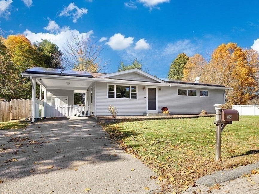
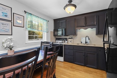
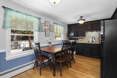
Be home for the Holidays! Discover the perfect blend of comfort & convenience in this updated 3-bedroom, 1-bath ranch. All the big-ticket items are done—including siding, windows, exterior doors and roof! Inside, enjoy true single-level living in an inviting open concept living room, highlighted by beautiful hardwood floors that flow throughout. This main living area opens to a refreshed kitchen featuring new countertops, painted cabinets & casual dining area. The home's 3 bedrooms all feature spacious closets and the full bathroom has been renovated w/modern finishes.The lower level extends your living space w/partially finished basement, complete w/ heated storage space & a separate heating zone for year-round comfort.The exterior is an entertainer's dream, boasting a fully fenced in yard, new above-ground pool w/deck surround, fire pit area, carport & multiple sheds for abundant storage. This home is the complete package—just move in and enjoy! New Septic installed in 2001.
Last Agent to Sell the Property
Better Living Real Estate, LLC Listed on: 10/22/2025
We collect this data history from publicly available records. To have your information removed, we recommend requesting removal directly through your county’s website.
| Date | Buyer | Sale Price | Title Company |
|---|---|---|---|
| Drabik Alexander | $470,000 | -- | |
| Fortier Peter | -- | None Available | |
| Fortier Peter | $204,000 | -- | |
| Fortier Peter P | $204,000 | -- | |
| Burt Rodney | $125,500 | -- | |
| Burt Rodney R | $125,500 | -- | |
| Denison David | $127,000 | -- |
We collect this data history from publicly available records. To have your information removed, we recommend requesting removal directly through your county’s website.
| Date | Status | Borrower | Loan Amount |
|---|---|---|---|
| Open | Drabik Alexander | $461,487 | |
| Previous Owner | Fortier Peter P | $193,800 | |
| Previous Owner | Denison David | $122,067 |
| Date | Event | Price | List to Sale | Price per Sq Ft |
|---|---|---|---|---|
| 12/29/2025 12/29/25 | Sold | $470,000 | 0.0% | $320 / Sq Ft |
| 11/25/2025 11/25/25 | Pending | -- | -- | -- |
| 11/19/2025 11/19/25 | Price Changed | $469,900 | -2.1% | $320 / Sq Ft |
| 10/28/2025 10/28/25 | Price Changed | $479,900 | -4.0% | $326 / Sq Ft |
| 10/22/2025 10/22/25 | For Sale | $499,900 | -- | $340 / Sq Ft |
| Year | Tax Paid | Tax Assessment Tax Assessment Total Assessment is a certain percentage of the fair market value that is determined by local assessors to be the total taxable value of land and additions on the property. | Land | Improvement |
|---|---|---|---|---|
| 2025 | $4,854 | $386,500 | $165,700 | $220,800 |
| 2024 | $4,658 | $362,200 | $151,300 | $210,900 |
| 2023 | $4,491 | $344,100 | $144,100 | $200,000 |
| 2022 | $4,379 | $311,000 | $120,200 | $190,800 |
| 2021 | $4,247 | $294,700 | $120,200 | $174,500 |
| 2020 | $3,969 | $279,100 | $120,200 | $158,900 |
| 2019 | $3,885 | $273,400 | $120,200 | $153,200 |
| 2018 | $3,577 | $248,200 | $115,500 | $132,700 |
| 2017 | $3,486 | $243,100 | $115,500 | $127,600 |
| 2016 | $3,322 | $232,500 | $113,600 | $118,900 |
| 2015 | $3,185 | $223,500 | $109,200 | $114,300 |
| 2014 | $3,193 | $217,800 | $106,700 | $111,100 |
Seller's Agent in 2025
Katelyn Cleveland
Better Living Real Estate, LLC
(508) 320-4685
3 in this area
58 Total Sales
Buyer's Agent in 2025
Heather Cunningham
Berkshire Hathaway HomeServices Evolution Properties
(508) 922-8104
1 in this area
52 Total Sales
Source: MLS Property Information Network (MLS PIN)
MLS Number: 73446467
APN: BELL-000092-000042
Disclaimer: Certain information contained herein is derived from information provided by parties other than Homes.com. All information provided is deemed reliable, but is not guaranteed to be accurate and should be independently verified.
![]() The property listing data and information, or the Images, set forth herein were provided to MLS Property Information Network, Inc. from third party sources, including sellers, lessors and public records, and were compiled by MLS Property Information Network, Inc. The property listing data and information, and the Images, are for the personal, non-commercial use of consumers having a good faith interest in purchasing or leasing listed properties of the type displayed to them and may not be used for any purpose other than to identify prospective properties which such consumers may have a good faith interest in purchasing or leasing. MLS Property Information Network, Inc. and its subscribers disclaim any and all representations and warranties as to the accuracy of the property listing data and information, or as to the accuracy of any of the Images, set forth herein.
The property listing data and information, or the Images, set forth herein were provided to MLS Property Information Network, Inc. from third party sources, including sellers, lessors and public records, and were compiled by MLS Property Information Network, Inc. The property listing data and information, and the Images, are for the personal, non-commercial use of consumers having a good faith interest in purchasing or leasing listed properties of the type displayed to them and may not be used for any purpose other than to identify prospective properties which such consumers may have a good faith interest in purchasing or leasing. MLS Property Information Network, Inc. and its subscribers disclaim any and all representations and warranties as to the accuracy of the property listing data and information, or as to the accuracy of any of the Images, set forth herein.
Ask me questions while you tour the home.