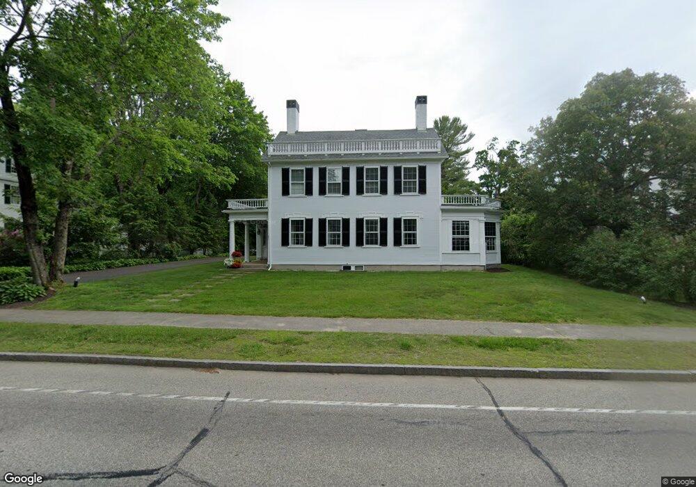
29 Summer St Kennebunk, ME 04043
Estimated Value: $1,219,000 - $2,213,000
4
Beds
5
Baths
4,650
Sq Ft
$358/Sq Ft
Est. Value
About This Home
This home is located at 29 Summer St, Kennebunk, ME 04043 and is currently estimated at $1,663,326, approximately $357 per square foot. 29 Summer St is a home located in York County with nearby schools including Kennebunk High School, School Around Us, and The New School.
Ownership History
Date
Name
Owned For
Owner Type
Purchase Details
Closed on
Jun 4, 2013
Sold by
Simko Caroline M
Bought by
Weaver Daniel P and Weaver Maureen A
Current Estimated Value
Purchase Details
Closed on
Jan 23, 2008
Sold by
Darin Robert M and Darin Sarah G
Bought by
Simko Caroline M
Home Financials for this Owner
Home Financials are based on the most recent Mortgage that was taken out on this home.
Original Mortgage
$417,000
Interest Rate
6.17%
Mortgage Type
Unknown
Create a Home Valuation Report for This Property
The Home Valuation Report is an in-depth analysis detailing your home's value as well as a comparison with similar homes in the area
Home Values in the Area
Average Home Value in this Area
Purchase History
| Date | Buyer | Sale Price | Title Company |
|---|---|---|---|
| Weaver Daniel P | -- | -- | |
| Simko Caroline M | -- | -- |
Source: Public Records
Mortgage History
| Date | Status | Borrower | Loan Amount |
|---|---|---|---|
| Previous Owner | Simko Caroline M | $570,622 | |
| Previous Owner | Simko Caroline M | $75,000 | |
| Previous Owner | Simko Caroline M | $417,000 | |
| Previous Owner | Simko Caroline M | $170,000 |
Source: Public Records
Tax History Compared to Growth
Tax History
| Year | Tax Paid | Tax Assessment Tax Assessment Total Assessment is a certain percentage of the fair market value that is determined by local assessors to be the total taxable value of land and additions on the property. | Land | Improvement |
|---|---|---|---|---|
| 2024 | $16,404 | $967,800 | $235,600 | $732,200 |
| 2023 | $15,533 | $967,800 | $235,600 | $732,200 |
| 2022 | $14,130 | $967,800 | $235,600 | $732,200 |
| 2021 | $11,380 | $798,600 | $235,600 | $563,000 |
| 2020 | $11,300 | $798,600 | $235,600 | $563,000 |
| 2019 | $0 | $1,059,600 | $294,400 | $765,200 |
| 2018 | $13,907 | $794,700 | $220,800 | $573,900 |
| 2017 | $0 | $794,700 | $220,800 | $573,900 |
| 2016 | $12,636 | $794,700 | $220,800 | $573,900 |
| 2015 | $12,159 | $794,700 | $220,800 | $573,900 |
| 2014 | $11,841 | $794,700 | $220,800 | $573,900 |
Source: Public Records
Map
Nearby Homes
- 45 Summer St Unit 1
- 17 Water St Unit 9
- 22 York St
- 47 Brown St
- 30 York St Unit 1
- 00 Summer St
- 17 Legacy Ln
- 11 Mousam Ridge Rd
- 61 Fletcher St
- 14 Wiggins Pond Ln
- 7 Acorn Cir
- 16 Boundary Way
- 20 Wonderbrook Dr
- 27 Webhannet Place Unit 16
- 7 Wonderbrook Dr
- 3 Hardwood Dr
- 28 Longfellow Ln Unit 15
- 31 Oakwood Ln
- 18 Greenwich Way Unit 38
- 39 Powder Mill Dr