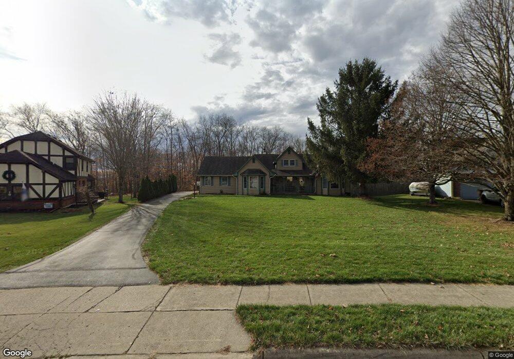
29 W Ellis Dr Waynesville, OH 45068
Wayne Township NeighborhoodEstimated Value: $379,000 - $447,000
3
Beds
2
Baths
2,279
Sq Ft
$179/Sq Ft
Est. Value
About This Home
This home is located at 29 W Ellis Dr, Waynesville, OH 45068 and is currently estimated at $408,997, approximately $179 per square foot. 29 W Ellis Dr is a home located in Warren County with nearby schools including Waynesville Elementary School, Waynesville Middle School, and Waynesville High School.
Ownership History
Date
Name
Owned For
Owner Type
Purchase Details
Closed on
May 3, 2018
Sold by
Rockhold Paul J and Rockhold Laurie
Bought by
Frazier Tyler J and Frazier Jaimie L
Current Estimated Value
Home Financials for this Owner
Home Financials are based on the most recent Mortgage that was taken out on this home.
Original Mortgage
$247,000
Outstanding Balance
$211,785
Interest Rate
4.22%
Mortgage Type
New Conventional
Estimated Equity
$197,212
Purchase Details
Closed on
Jul 2, 1991
Sold by
Ball Ball and Ball Richard
Bought by
Rockhold Rockhold and Rockhold Paul J
Purchase Details
Closed on
May 29, 1987
Sold by
Lucas Lucas and Lucas Robert H
Bought by
Ball and Ball Richard
Purchase Details
Closed on
Dec 31, 1986
Sold by
Lucas Lucas and Lucas Robert H
Bought by
Lucas and Robert H
Purchase Details
Closed on
Dec 15, 1981
Sold by
Waynesville Development &
Purchase Details
Closed on
Aug 4, 1978
Sold by
Waynesville Development &
Create a Home Valuation Report for This Property
The Home Valuation Report is an in-depth analysis detailing your home's value as well as a comparison with similar homes in the area
Home Values in the Area
Average Home Value in this Area
Purchase History
| Date | Buyer | Sale Price | Title Company |
|---|---|---|---|
| Frazier Tyler J | $260,000 | -- | |
| Rockhold Rockhold | $140,000 | -- | |
| Ball | $16,400 | -- | |
| Lucas | -- | -- | |
| -- | -- | -- | |
| -- | -- | -- |
Source: Public Records
Mortgage History
| Date | Status | Borrower | Loan Amount |
|---|---|---|---|
| Open | Frazier Tyler J | $247,000 |
Source: Public Records
Tax History Compared to Growth
Tax History
| Year | Tax Paid | Tax Assessment Tax Assessment Total Assessment is a certain percentage of the fair market value that is determined by local assessors to be the total taxable value of land and additions on the property. | Land | Improvement |
|---|---|---|---|---|
| 2024 | $4,932 | $112,670 | $21,000 | $91,670 |
| 2023 | $4,468 | $88,501 | $12,915 | $75,586 |
| 2022 | $4,380 | $88,501 | $12,915 | $75,586 |
| 2021 | $4,219 | $88,501 | $12,915 | $75,586 |
| 2020 | $3,994 | $71,953 | $10,500 | $61,453 |
| 2019 | $3,996 | $71,953 | $10,500 | $61,453 |
| 2018 | $3,997 | $71,953 | $10,500 | $61,453 |
| 2017 | $4,286 | $72,006 | $10,675 | $61,331 |
| 2016 | $4,030 | $72,006 | $10,675 | $61,331 |
| 2015 | $4,037 | $72,006 | $10,675 | $61,331 |
| 2014 | $3,992 | $67,290 | $9,980 | $57,320 |
| 2013 | $3,985 | $70,840 | $10,500 | $60,340 |
Source: Public Records
Map
Nearby Homes
- 60 E Ellis Dr
- 1106 Brookfield Dr Unit 1106
- 1036 Bayberry Dr
- 1198 Lytle Rd
- 460 Miami St
- 53 S 4th St
- 196 S 3rd St
- 363 Victoria Place
- 155 S Main St
- 401 Wilkerson Ln
- 1 Cumberland Ct
- 0 Ohio 73 Unit 944080
- 350 Somerset Ln
- 437 N Main St
- 4752 E Lower Springboro Rd
- 7219 N Route 42
- 7219 U S 42
- 3950 E State Route 73
- 7219 N Us Rt 42
- 4 Corwin Rd