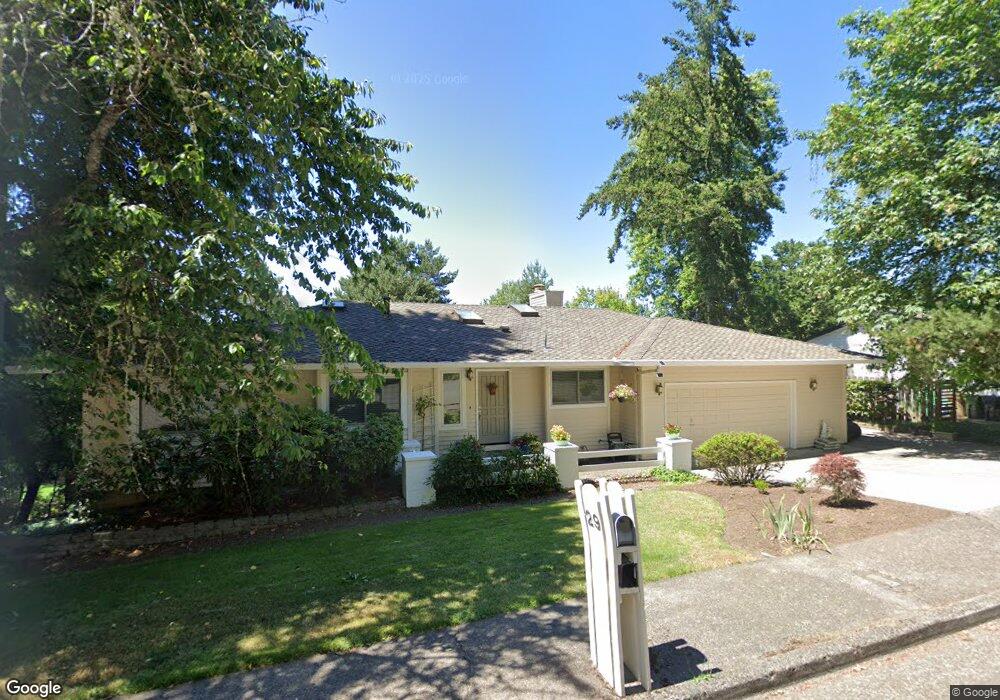
29 Westridge Dr Lake Oswego, OR 97034
Westridge NeighborhoodEstimated Value: $1,024,000 - $1,438,000
5
Beds
3
Baths
2,929
Sq Ft
$399/Sq Ft
Est. Value
About This Home
This home is located at 29 Westridge Dr, Lake Oswego, OR 97034 and is currently estimated at $1,167,460, approximately $398 per square foot. 29 Westridge Dr is a home located in Clackamas County with nearby schools including Lakeridge Middle School, Lakeridge High School, and The Children's Hour Academy.
Ownership History
Date
Name
Owned For
Owner Type
Purchase Details
Closed on
Sep 20, 2023
Sold by
Ito Family Trust
Bought by
Ito Family Trust and Sanae Ito Trust
Current Estimated Value
Purchase Details
Closed on
Dec 21, 2017
Sold by
Ito Fumtosh
Bought by
Ito Fumitoshi and Ito Living Trust
Purchase Details
Closed on
Oct 13, 1999
Sold by
Matthews Ronald D and Matthews Linda C
Bought by
Ito Fumitoshi and Ito Sanae
Create a Home Valuation Report for This Property
The Home Valuation Report is an in-depth analysis detailing your home's value as well as a comparison with similar homes in the area
Home Values in the Area
Average Home Value in this Area
Purchase History
| Date | Buyer | Sale Price | Title Company |
|---|---|---|---|
| Ito Family Trust | -- | None Listed On Document | |
| Ito Fumitoshi | -- | None Available | |
| Ito Fumitoshi | $305,000 | Fidelity National Title Co |
Source: Public Records
Tax History Compared to Growth
Tax History
| Year | Tax Paid | Tax Assessment Tax Assessment Total Assessment is a certain percentage of the fair market value that is determined by local assessors to be the total taxable value of land and additions on the property. | Land | Improvement |
|---|---|---|---|---|
| 2025 | $9,944 | $518,962 | -- | -- |
| 2024 | $9,370 | $487,747 | -- | -- |
| 2023 | $9,370 | $473,541 | $0 | $0 |
| 2022 | $8,825 | $459,749 | $0 | $0 |
| 2021 | $8,150 | $446,359 | $0 | $0 |
| 2020 | $7,945 | $433,359 | $0 | $0 |
| 2019 | $7,750 | $420,737 | $0 | $0 |
| 2018 | $7,370 | $408,483 | $0 | $0 |
| 2017 | $7,111 | $396,585 | $0 | $0 |
| 2016 | $6,473 | $385,034 | $0 | $0 |
| 2015 | $6,253 | $373,819 | $0 | $0 |
| 2014 | $6,083 | $362,931 | $0 | $0 |
Source: Public Records
Map
Nearby Homes
- 18300 Bryant Rd
- 12 Dover Way
- 18706 Bryant Rd
- 17677 Westview Dr
- 18815 Hilltop Rd
- 4023 Melissa Dr
- 18100 Bryant Rd
- 4123 Chad Dr
- 19229 35th Place
- 17901 Hillside Dr
- 17810 Sarah Hill Ln
- 4280 Bernard St
- 17210 Cedar Rd
- 17035 Westview Dr
- 4201 Childs Rd
- 17367 Canal Cir
- 4224 Haven St
- 2306 Mayors Ln
- 3777 Rivers Edge Dr
- 2627 Park Rd
- 31 Westridge Dr
- 27 Westridge Dr
- 30 Westridge Dr
- 28 Westridge Dr
- 33 Westridge Dr
- 25 Westridge Dr
- 32 Westridge Dr
- 2 Buckingham Terrace
- 39 Westridge Dr
- 39 Westridge Dr
- 26 Westridge Dr
- 23 Westridge Dr
- 35 Westridge Dr
- 2 Camelot Ct
- 24 Westridge Dr
- 4 Buckingham Terrace
- 5 Buckingham Terrace
- 4 Camelot Ct
- 0 Camelot Ct
- 21 Westridge Dr