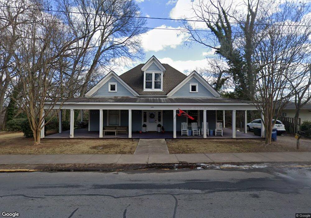
290 Barber St Athens, GA 30601
Newtown NeighborhoodEstimated Value: $760,989 - $1,109,000
6
Beds
3
Baths
3,684
Sq Ft
$243/Sq Ft
Est. Value
About This Home
This home is located at 290 Barber St, Athens, GA 30601 and is currently estimated at $893,497, approximately $242 per square foot. 290 Barber St is a home located in Clarke County with nearby schools including Johnnie Lay Burks Elementary School, Clarke Middle School, and Clarke Central High School.
Ownership History
Date
Name
Owned For
Owner Type
Purchase Details
Closed on
Dec 23, 2011
Sold by
Lyons Ian G
Bought by
Peterson Christopher R
Current Estimated Value
Home Financials for this Owner
Home Financials are based on the most recent Mortgage that was taken out on this home.
Original Mortgage
$256,500
Interest Rate
4.07%
Mortgage Type
Purchase Money Mortgage
Purchase Details
Closed on
Sep 14, 2001
Sold by
Laflamme Daniel F and Laflamme Anne M
Bought by
Lyons Ian G and Sheryl Jean Lyons
Purchase Details
Closed on
Oct 23, 1996
Sold by
Muldrew Allen
Bought by
Laflamme Daniel F and Laflamme Anne M
Create a Home Valuation Report for This Property
The Home Valuation Report is an in-depth analysis detailing your home's value as well as a comparison with similar homes in the area
Home Values in the Area
Average Home Value in this Area
Purchase History
| Date | Buyer | Sale Price | Title Company |
|---|---|---|---|
| Peterson Christopher R | $205,000 | -- | |
| Lyons Ian G | $203,000 | -- | |
| Laflamme Daniel F | $82,000 | -- |
Source: Public Records
Mortgage History
| Date | Status | Borrower | Loan Amount |
|---|---|---|---|
| Closed | Peterson Christopher R | $256,500 |
Source: Public Records
Tax History
| Year | Tax Paid | Tax Assessment Tax Assessment Total Assessment is a certain percentage of the fair market value that is determined by local assessors to be the total taxable value of land and additions on the property. | Land | Improvement |
|---|---|---|---|---|
| 2025 | $7,081 | $228,045 | $32,805 | $195,240 |
| 2024 | $7,081 | $228,045 | $32,805 | $195,240 |
| 2023 | $7,126 | $228,045 | $32,805 | $195,240 |
| 2022 | $5,967 | $187,059 | $32,805 | $154,254 |
| 2021 | $5,436 | $161,311 | $32,805 | $128,506 |
| 2020 | $5,362 | $159,121 | $32,805 | $126,316 |
| 2019 | $5,024 | $151,166 | $36,000 | $115,166 |
| 2018 | $4,954 | $145,918 | $36,000 | $109,918 |
| 2017 | $4,855 | $143,014 | $40,500 | $102,514 |
| 2016 | $4,512 | $132,905 | $42,750 | $90,155 |
| 2015 | $4,464 | $131,303 | $42,750 | $88,553 |
| 2014 | $4,369 | $128,320 | $45,000 | $83,320 |
Source: Public Records
Map
Nearby Homes
- 668 Pulaski St
- 600 Pulaski St
- 570 Prince Ave
- 100 Prince Ave Unit A404
- 100 Prince Ave Unit A407
- 250 Cleveland Ave Unit 219
- 390 Athens Ave
- 860 College Ave
- 940 College Ave
- 800 College Ave
- 524 Hill St
- 947 N Chase St
- 269 N Hull St Unit 212
- 250 W Broad St Unit 615
- 250 W Broad St Unit 714
- 250 W Broad St Unit 801
- 250 W Broad St Unit 408
- 250 W Broad St Unit 405
- 247 E Washington St Unit 302
- 247 E Washington St Unit 207
Your Personal Tour Guide
Ask me questions while you tour the home.