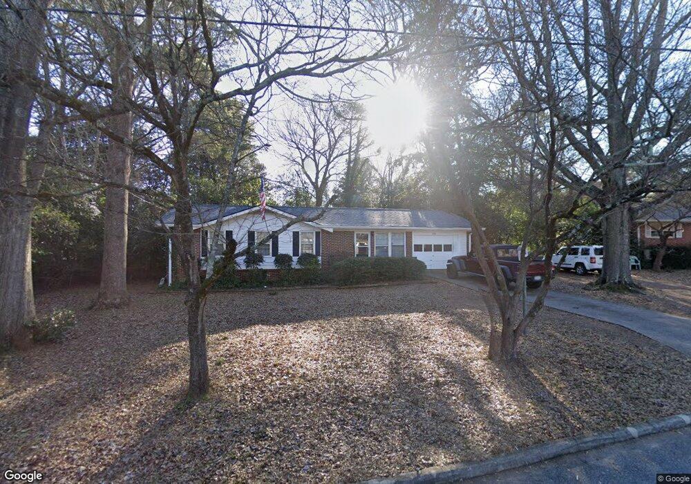
290 Clarke Dr Athens, GA 30605
Estimated Value: $267,801 - $286,000
3
Beds
2
Baths
1,311
Sq Ft
$211/Sq Ft
Est. Value
About This Home
This home is located at 290 Clarke Dr, Athens, GA 30605 and is currently estimated at $277,200, approximately $211 per square foot. 290 Clarke Dr is a home located in Clarke County with nearby schools including Barnett Shoals Elementary School, Hilsman Middle School, and Cedar Shoals High School.
Ownership History
Date
Name
Owned For
Owner Type
Purchase Details
Closed on
Jan 16, 2004
Sold by
Stevens Joel Hampton
Bought by
Vaughn David E and Josephine Vaughn
Current Estimated Value
Purchase Details
Closed on
Jan 8, 2004
Sold by
Stevens Joel Hampton
Bought by
Stevens Joel Hampton
Purchase Details
Closed on
Apr 1, 1999
Sold by
Edwards Charlotte
Bought by
Stevens Joel Hampton
Purchase Details
Closed on
Jul 25, 1995
Sold by
Huot Donald L
Bought by
Edwards Charlotte
Purchase Details
Closed on
Feb 6, 1990
Sold by
Chastain James Rick By Aif
Bought by
Huot Donald L
Create a Home Valuation Report for This Property
The Home Valuation Report is an in-depth analysis detailing your home's value as well as a comparison with similar homes in the area
Purchase History
| Date | Buyer | Sale Price | Title Company |
|---|---|---|---|
| Vaughn David E | -- | -- | |
| Stevens Joel Hampton | -- | -- | |
| Stevens Joel Hampton | $77,500 | -- | |
| Edwards Charlotte | $56,000 | -- | |
| Huot Donald L | $50,000 | -- |
Source: Public Records
Tax History
| Year | Tax Paid | Tax Assessment Tax Assessment Total Assessment is a certain percentage of the fair market value that is determined by local assessors to be the total taxable value of land and additions on the property. | Land | Improvement |
|---|---|---|---|---|
| 2025 | $2,832 | $91,221 | $12,000 | $79,221 |
| 2024 | $2,832 | $86,043 | $12,000 | $74,043 |
| 2023 | $2,689 | $76,999 | $12,000 | $64,999 |
| 2022 | $1,937 | $60,724 | $10,400 | $50,324 |
| 2021 | $1,622 | $48,121 | $10,400 | $37,721 |
| 2020 | $1,575 | $46,723 | $10,400 | $36,323 |
| 2019 | $1,543 | $45,446 | $10,400 | $35,046 |
| 2018 | $1,390 | $40,936 | $10,400 | $30,536 |
| 2017 | $0 | $35,321 | $10,400 | $24,921 |
| 2016 | $1,141 | $33,600 | $10,400 | $23,200 |
| 2015 | $1,191 | $35,038 | $10,400 | $24,638 |
| 2014 | $1,205 | $35,376 | $10,400 | $24,976 |
Source: Public Records
Map
Nearby Homes
- 150 Rumson Rd
- 2535 Barnett Shoals Rd
- 189 Ashbrook Dr
- 331 Greencrest Dr
- 140 Ashbrook Dr
- 352 Greencrest Dr
- 109 Layla Ct
- 148 Warren Way
- 0 Barnett Shoals Rd Unit Lot 1
- 140 Whitehall Rd
- 119 Pine Ridge Trace
- 625 Forest Rd
- 431 College Cir
- 400 Ansley Dr
- 256 Scandia Cir
- 325 Segrest Cir
- 337 Georgetown Dr
- 1055 College Station Rd
- 29 N Stratford Dr
- 100 Ansonborough Ln
Your Personal Tour Guide
Ask me questions while you tour the home.