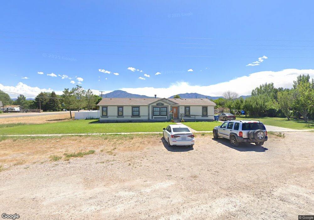
290 N 400 W Fillmore, UT 84631
Estimated Value: $292,000 - $384,000
4
Beds
2
Baths
1,792
Sq Ft
$185/Sq Ft
Est. Value
About This Home
This home is located at 290 N 400 W, Fillmore, UT 84631 and is currently estimated at $331,471, approximately $184 per square foot. 290 N 400 W is a home located in Millard County.
Ownership History
Date
Name
Owned For
Owner Type
Purchase Details
Closed on
Jul 25, 2024
Sold by
Darnell Colton R and Darnell Richard
Bought by
Sandoval Luis and Garcia Diana Vanessa
Current Estimated Value
Home Financials for this Owner
Home Financials are based on the most recent Mortgage that was taken out on this home.
Original Mortgage
$289,890
Outstanding Balance
$286,141
Interest Rate
6.95%
Mortgage Type
FHA
Estimated Equity
$45,330
Purchase Details
Closed on
Aug 16, 2021
Sold by
Darnell Colton R
Bought by
Darnell Colton R and Darnell Richard
Home Financials for this Owner
Home Financials are based on the most recent Mortgage that was taken out on this home.
Original Mortgage
$188,200
Interest Rate
2.9%
Mortgage Type
New Conventional
Purchase Details
Closed on
Dec 1, 2018
Sold by
Oeppinger Deborah Sue
Bought by
Darnell Colton R
Purchase Details
Closed on
Jul 31, 2008
Sold by
Oeppinger Carl E
Bought by
Oeppinger Carl E and Oeppinger Deborah Sue
Create a Home Valuation Report for This Property
The Home Valuation Report is an in-depth analysis detailing your home's value as well as a comparison with similar homes in the area
Home Values in the Area
Average Home Value in this Area
Purchase History
| Date | Buyer | Sale Price | Title Company |
|---|---|---|---|
| Sandoval Luis | -- | First American Title Insurance | |
| Darnell Colton R | -- | First American Title | |
| Darnell Colton R | -- | First American Title | |
| Darnell Colton R | -- | -- | |
| Oeppinger Carl E | -- | -- |
Source: Public Records
Mortgage History
| Date | Status | Borrower | Loan Amount |
|---|---|---|---|
| Open | Sandoval Luis | $289,890 | |
| Previous Owner | Darnell Colton R | $188,200 |
Source: Public Records
Tax History Compared to Growth
Tax History
| Year | Tax Paid | Tax Assessment Tax Assessment Total Assessment is a certain percentage of the fair market value that is determined by local assessors to be the total taxable value of land and additions on the property. | Land | Improvement |
|---|---|---|---|---|
| 2025 | $1,026 | $128,873 | $32,761 | $96,112 |
| 2024 | $1,026 | $110,376 | $25,365 | $85,011 |
| 2023 | $1,225 | $110,376 | $25,365 | $85,011 |
| 2022 | $1,018 | $91,440 | $23,060 | $68,380 |
| 2021 | $873 | $75,256 | $14,974 | $60,282 |
| 2020 | $805 | $69,847 | $13,613 | $56,234 |
| 2019 | $803 | $69,847 | $13,613 | $56,234 |
| 2018 | $657 | $58,457 | $13,613 | $44,844 |
| 2017 | $0 | $47,678 | $13,613 | $34,065 |
| 2016 | $539 | $47,678 | $13,613 | $34,065 |
| 2015 | $539 | $47,678 | $13,613 | $34,065 |
| 2014 | -- | $47,678 | $13,613 | $34,065 |
| 2013 | -- | $47,678 | $13,613 | $34,065 |
Source: Public Records
Map
Nearby Homes
- 335 W 400 North St
- 225 W 200 St N
- 380 N 200 St W
- 295 N 100 West St
- 165 N 100 W
- 390 N 100 W
- 410 W 400 N
- 75 N 100 West St
- 40 S 100 Rd E
- 310 S 500 West Rd
- 120 S 100 East Rd
- 190 W 400 St S
- 220 S 200 E
- 155 E 500 St S
- 157 E 500 South St
- 2155 N Cedar Mountain Rd
- 2835 N Cedar Mountain Rd
- 430 E Canyon Rd
- 405 E 500 St S
- 310 S 600 E