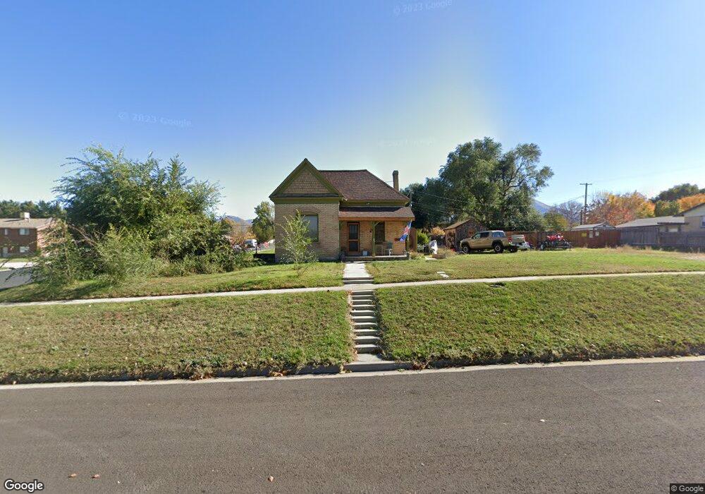
290 N 600 E Spanish Fork, UT 84660
Estimated Value: $380,000 - $389,000
2
Beds
2
Baths
1,317
Sq Ft
$291/Sq Ft
Est. Value
About This Home
This home is located at 290 N 600 E, Spanish Fork, UT 84660 and is currently estimated at $383,271, approximately $291 per square foot. 290 N 600 E is a home located in Utah County with nearby schools including Park Elementary School, Spanish Fork Jr High School, and Spanish Fork High School.
Ownership History
Date
Name
Owned For
Owner Type
Purchase Details
Closed on
Jul 12, 2001
Sold by
Johnson John Gregory
Bought by
Johnson Rulon H
Current Estimated Value
Home Financials for this Owner
Home Financials are based on the most recent Mortgage that was taken out on this home.
Original Mortgage
$66,100
Outstanding Balance
$25,492
Interest Rate
7.15%
Estimated Equity
$357,779
Purchase Details
Closed on
Dec 23, 1999
Sold by
Johnson Rulon H
Bought by
Johnson John Gegory
Purchase Details
Closed on
Oct 23, 1999
Sold by
Johnson Rulon H
Bought by
Johnson John Gregory
Purchase Details
Closed on
Jun 9, 1997
Sold by
Johnson Connie
Bought by
Johnson Rulon H
Home Financials for this Owner
Home Financials are based on the most recent Mortgage that was taken out on this home.
Original Mortgage
$62,000
Interest Rate
7.92%
Create a Home Valuation Report for This Property
The Home Valuation Report is an in-depth analysis detailing your home's value as well as a comparison with similar homes in the area
Home Values in the Area
Average Home Value in this Area
Purchase History
| Date | Buyer | Sale Price | Title Company |
|---|---|---|---|
| Johnson Rulon H | -- | Empire Land Title Company | |
| Johnson John Gegory | -- | -- | |
| Johnson John Gregory | -- | -- | |
| Johnson Rulon H | -- | -- |
Source: Public Records
Mortgage History
| Date | Status | Borrower | Loan Amount |
|---|---|---|---|
| Open | Johnson Rulon H | $66,100 | |
| Closed | Johnson Rulon H | $62,000 |
Source: Public Records
Tax History
| Year | Tax Paid | Tax Assessment Tax Assessment Total Assessment is a certain percentage of the fair market value that is determined by local assessors to be the total taxable value of land and additions on the property. | Land | Improvement |
|---|---|---|---|---|
| 2025 | $1,900 | $181,170 | -- | -- |
| 2024 | $1,900 | $174,680 | $0 | $0 |
| 2023 | $1,748 | $180,400 | $0 | $0 |
| 2022 | $1,706 | $172,700 | $0 | $0 |
| 2021 | $1,474 | $238,700 | $86,400 | $152,300 |
| 2020 | $1,329 | $209,200 | $72,000 | $137,200 |
| 2019 | $1,155 | $191,300 | $72,000 | $119,300 |
| 2018 | $1,098 | $175,700 | $72,000 | $103,700 |
| 2017 | $958 | $82,445 | $0 | $0 |
| 2016 | $841 | $71,390 | $0 | $0 |
| 2015 | $762 | $63,965 | $0 | $0 |
| 2014 | $710 | $59,785 | $0 | $0 |
Source: Public Records
Map
Nearby Homes
- 374 N 500 E
- 284 N 400 E
- 590 N 400 E
- 284 N 1000 E
- 306 N 1070 E
- 306 N 1070 E Unit 17
- 274 N 1070 E Unit 14
- 299 N 1070 E Unit 8
- 212 N 1070 E Unit 9
- 224 N 1070 E Unit 10
- 440 N 200 E
- 314 N 1070 E
- 973 E 60 S
- 998 E 260 N Unit 16
- 992 E 260 N Unit 15
- 1108 E 260 N
- 330 E 700 N
- 136 N 1120 E
- 277 S 700 E
- 573 E 300 S
Your Personal Tour Guide
Ask me questions while you tour the home.