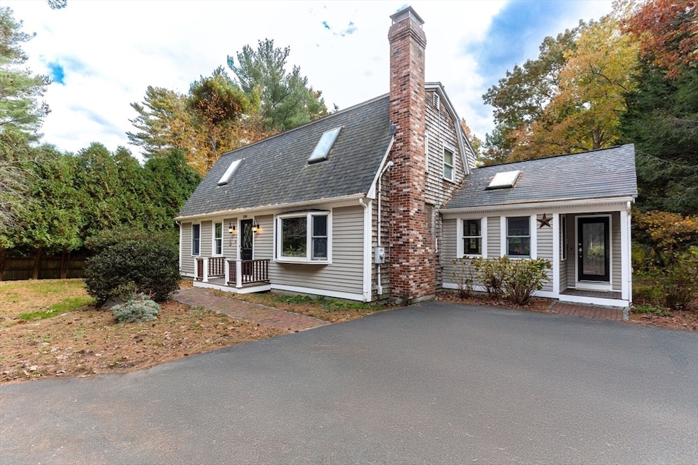
290 S River St Marshfield, MA 02050
Estimated payment $5,277/month
Highlights
- Beach Front
- Golf Course Community
- Medical Services
- South River Rated 9+
- Community Stables
- Open Floorplan
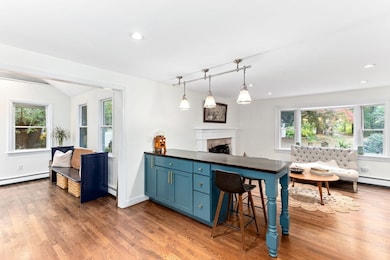
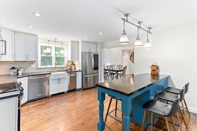
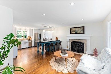
About This Home
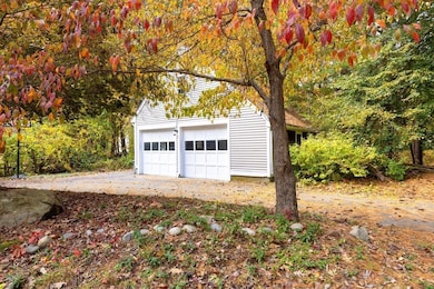
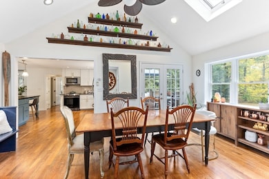
Welcome to this open concept Gambrel Dutch Style Colonial featuring 3 bedrooms, with 2.5 baths set on a picturesque one-acre lot in the heart of Marshfield. Step inside to discover a bright open floor plan blending style and practicality for modern convenience. Sunlight fills the home highlighting the inviting living spaces and flexible layout, the finished basement offers additional living space, and a bathroom along with ample storage. Enjoy the detached two car garage with workspace and flex space over the garage that offers endless possibilities, The fenced yard with large mahogany deck provides a great area for entertaining with a true sense of privacy. Ideally located close to shopping, dining, entertainment and beautiful beaches. This home is conveniently located minutes from Rte 3 offering an easy commute. A wonderful opportunity to own a timeless home that offers space, privacy, and modern comfort in a sought-after location.

Home Details
Home Type
- Single Family
Est. Annual Taxes
- $7,218
Year Built
- Built in 1985
Lot Details
- 1 Acre Lot
- Beach Front
- Fenced
- Wooded Lot
Parking
- 2 Car Detached Garage
- Parking Storage or Cabinetry
- Workshop in Garage
- Side Facing Garage
- Driveway
- 6 Open Parking Spaces
Home Design
- Frame Construction
- Shingle Roof
- Concrete Perimeter Foundation
Interior Spaces
- Open Floorplan
- Cathedral Ceiling
- Ceiling Fan
- Skylights
- Decorative Lighting
- Bay Window
- French Doors
- Living Room with Fireplace
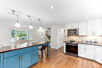
Kitchen
- Breakfast Bar
- Range
- Microwave
- Dishwasher
- Upgraded Countertops
- Disposal
Flooring
- Wood
- Wall to Wall Carpet
- Ceramic Tile
Bedrooms and Bathrooms
- 3 Bedrooms
- Primary bedroom located on second floor
Laundry
- Dryer
- Washer
Finished Basement
- Basement Fills Entire Space Under The House
- Laundry in Basement
Outdoor Features
- Bulkhead
- Deck
- Patio
- Porch
Location
- Property is near public transit and schools
Schools
- South River Elementary School
- Furnace Brook Middle School
- Marshfield High School
Utilities
- Window Unit Cooling System
- 4 Heating Zones
- Heating System Uses Oil
- Baseboard Heating
- 220 Volts
- Electric Water Heater
- Private Sewer
Listing and Financial Details
- Legal Lot and Block 0008 / 0003
- Assessor Parcel Number 1071383
Community Details
Overview
- No Home Owners Association
- Near Conservation Area
Amenities
- Medical Services
- Shops
- Coin Laundry
Recreation
- Golf Course Community
- Park
- Community Stables
- Jogging Path
Map
Home Values in the Area
Average Home Value in this Area
Tax History
| Year | Tax Paid | Tax Assessment Tax Assessment Total Assessment is a certain percentage of the fair market value that is determined by local assessors to be the total taxable value of land and additions on the property. | Land | Improvement |
|---|---|---|---|---|
| 2025 | $7,218 | $729,100 | $320,200 | $408,900 |
| 2024 | $7,080 | $681,400 | $304,900 | $376,500 |
| 2023 | $6,605 | $611,300 | $283,100 | $328,200 |
| 2022 | $6,605 | $510,000 | $228,700 | $281,300 |
| 2021 | $6,351 | $481,500 | $226,500 | $255,000 |
| 2020 | $6,069 | $455,300 | $206,900 | $248,400 |
| 2019 | $5,915 | $442,100 | $206,900 | $235,200 |
| 2018 | $5,852 | $437,700 | $206,900 | $230,800 |
| 2017 | $5,654 | $412,100 | $196,000 | $216,100 |
| 2016 | $5,383 | $387,800 | $185,100 | $202,700 |
| 2015 | $5,094 | $383,300 | $185,100 | $198,200 |
| 2014 | $4,802 | $361,300 | $169,900 | $191,400 |
Property History
| Date | Event | Price | List to Sale | Price per Sq Ft |
|---|---|---|---|---|
| 03/03/2026 03/03/26 | Pending | -- | -- | -- |
| 02/26/2026 02/26/26 | Price Changed | $875,000 | 0.0% | $331 / Sq Ft |
| 02/26/2026 02/26/26 | For Sale | $875,000 | -2.7% | $331 / Sq Ft |
| 12/03/2025 12/03/25 | Off Market | $899,000 | -- | -- |
| 11/13/2025 11/13/25 | Price Changed | $899,000 | -5.4% | $340 / Sq Ft |
| 10/29/2025 10/29/25 | For Sale | $950,000 | -- | $359 / Sq Ft |
Purchase History
| Date | Type | Sale Price | Title Company |
|---|---|---|---|
| Quit Claim Deed | -- | None Available | |
| Quit Claim Deed | -- | None Available | |
| Quit Claim Deed | -- | -- | |
| Deed | $449,000 | -- | |
| Deed | $449,000 | -- | |
| Deed | $415,000 | -- |
Mortgage History
| Date | Status | Loan Amount | Loan Type |
|---|---|---|---|
| Previous Owner | $310,000 | New Conventional | |
| Previous Owner | $417,000 | Purchase Money Mortgage |
Source: MLS Property Information Network (MLS PIN)
MLS Number: 73448901
APN: MARS-000009H-000003-000008
Disclaimer: Certain information contained herein is derived from information provided by parties other than Homes.com. All information provided is deemed reliable, but is not guaranteed to be accurate and should be independently verified.
![]() The property listing data and information, or the Images, set forth herein were provided to MLS Property Information Network, Inc. from third party sources, including sellers, lessors and public records, and were compiled by MLS Property Information Network, Inc. The property listing data and information, and the Images, are for the personal, non-commercial use of consumers having a good faith interest in purchasing or leasing listed properties of the type displayed to them and may not be used for any purpose other than to identify prospective properties which such consumers may have a good faith interest in purchasing or leasing. MLS Property Information Network, Inc. and its subscribers disclaim any and all representations and warranties as to the accuracy of the property listing data and information, or as to the accuracy of any of the Images, set forth herein.
The property listing data and information, or the Images, set forth herein were provided to MLS Property Information Network, Inc. from third party sources, including sellers, lessors and public records, and were compiled by MLS Property Information Network, Inc. The property listing data and information, and the Images, are for the personal, non-commercial use of consumers having a good faith interest in purchasing or leasing listed properties of the type displayed to them and may not be used for any purpose other than to identify prospective properties which such consumers may have a good faith interest in purchasing or leasing. MLS Property Information Network, Inc. and its subscribers disclaim any and all representations and warranties as to the accuracy of the property listing data and information, or as to the accuracy of any of the Images, set forth herein.
Ask me questions while you tour the home.