Estimated Value: $243,000 - $269,091
--
Bed
2
Baths
1,392
Sq Ft
$184/Sq Ft
Est. Value
About This Home
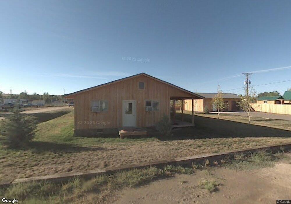
This home is located at 290 W Osborne St, Baggs, WY 82321 and is currently estimated at $256,046, approximately $183 per square foot. 290 W Osborne St is a home located in Carbon County with nearby schools including Little Snake River Valley School.
Ownership History
Date
Name
Owned For
Owner Type
Purchase Details
Closed on
Jun 25, 2024
Sold by
Corson Brothers Enterprises Llc and Elkhead Investing Llc
Bought by
Raftopoulos Katherine S
Current Estimated Value
Purchase Details
Closed on
Mar 30, 2021
Sold by
Corson Donald R and Cb Sand And Gravel Inc
Bought by
Corson Brothers Enterprises Llc
Purchase Details
Closed on
Nov 21, 2012
Sold by
Southern Cross Environmental Services Ll
Bought by
C & B Sand & Gravel Inc and Elkhead Investing Llc
Purchase Details
Closed on
Aug 10, 2009
Sold by
88 Ranch Llc
Bought by
Southern Cross Environmental Services Ll
Purchase Details
Closed on
Mar 1, 2006
Sold by
Latham Enterprises Two Llc
Bought by
88 Ranch Llc
Create a Home Valuation Report for This Property
The Home Valuation Report is an in-depth analysis detailing your home's value as well as a comparison with similar homes in the area
Home Values in the Area
Average Home Value in this Area
Purchase History
| Date | Buyer | Sale Price | Title Company |
|---|---|---|---|
| Raftopoulos Katherine S | -- | First American Title | |
| Corson Brothers Enterprises Llc | -- | None Available | |
| Corson Brothers Enterprises Llc | -- | None Listed On Document | |
| C & B Sand & Gravel Inc | -- | None Available | |
| Southern Cross Environmental Services Ll | -- | None Available | |
| 88 Ranch Llc | -- | None Available |
Source: Public Records
Tax History Compared to Growth
Tax History
| Year | Tax Paid | Tax Assessment Tax Assessment Total Assessment is a certain percentage of the fair market value that is determined by local assessors to be the total taxable value of land and additions on the property. | Land | Improvement |
|---|---|---|---|---|
| 2025 | $1,613 | $20,735 | $2,534 | $18,201 |
| 2024 | $1,613 | $20,336 | $2,242 | $18,094 |
| 2023 | $1,646 | $20,761 | $2,242 | $18,519 |
| 2022 | $1,504 | $18,725 | $1,823 | $16,902 |
| 2021 | $1,504 | $17,865 | $1,823 | $16,042 |
| 2020 | $1,348 | $51,252 | $5,469 | $45,783 |
| 2019 | $1,394 | $17,936 | $1,823 | $16,113 |
| 2018 | $1,178 | $15,053 | $1,823 | $13,230 |
| 2017 | $1,179 | $15,089 | $1,814 | $13,275 |
| 2016 | $1,090 | $14,036 | $1,814 | $12,222 |
| 2015 | -- | $15,061 | $1,814 | $13,247 |
| 2014 | -- | $14,944 | $1,814 | $13,130 |
Source: Public Records
Map
Nearby Homes
- 00 Highway 789
- 3 Cowpoke Rd
- 8 Battle Cir
- 11388 Cr 101
- 20347 County Road 3
- 191 Boulder Dr
- 889 Granite Rd
- 242 Boulder Dr
- 638 Little Willow Rd
- 6919 County Road 1
- 101 Boulder Bypass
- 189 Boulder Bypass
- 277 Boulder Bypass
- 2175 Boulder Dr
- 8316 Boulder Dr
- TBD Boulder Drive Lot 397
- 1901 Boulder Dr
- 2004 Boulder Drive Lot 396
- 6391 Moffat County Road 1
- Tbd Cr 82
- 268 E Highway 70
- 285 Osborne St
- 95 S Penland St
- 270 North St
- 260 North St
- 0 Lower Four Mile Ranch Unit 57542
- 370 S Penland St
- 210 Penland St
- 20 S Penland St
- 131 N Miles St
- 191 N Miles St
- 175 N Miles St
- 45 S Miles St
- 91 S Miles St
- 225 S Miles St
- 120 N Miles St
- 250 S Miles St
- 235 S Miles St
- 145 Magar St
- 40 S Miles St