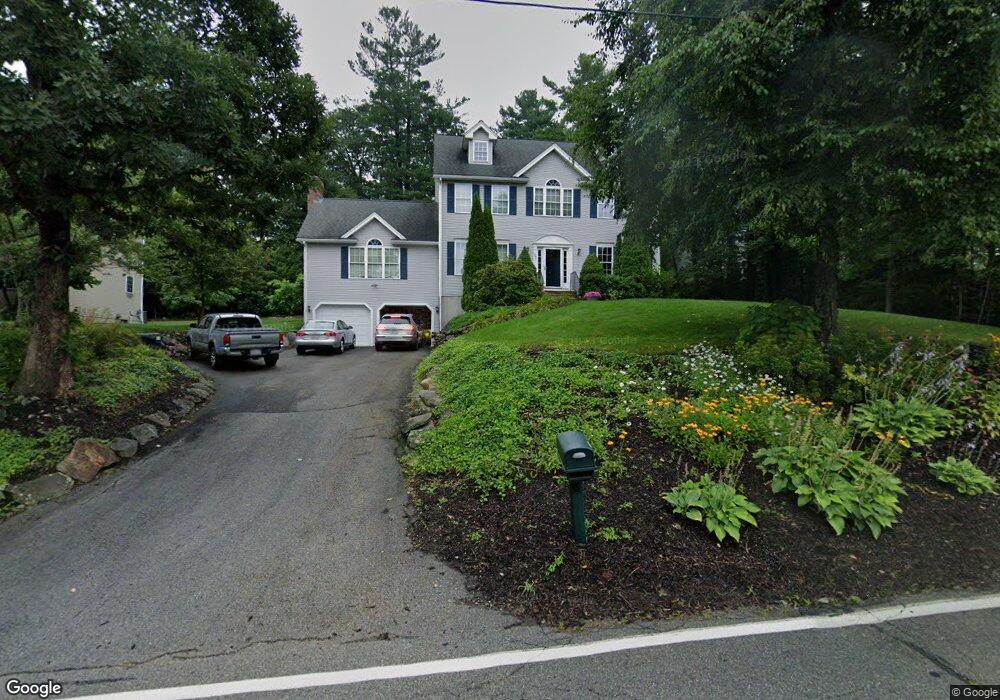
290 Wachusett St Holden, MA 01520
Estimated Value: $694,000 - $788,000
4
Beds
3
Baths
2,500
Sq Ft
$299/Sq Ft
Est. Value
About This Home
This home is located at 290 Wachusett St, Holden, MA 01520 and is currently estimated at $747,352, approximately $298 per square foot. 290 Wachusett St is a home located in Worcester County with nearby schools including Wachusett Regional High School, Holden Christian Academy, and Bancroft School.
Ownership History
Date
Name
Owned For
Owner Type
Purchase Details
Closed on
Mar 4, 2024
Sold by
Kelley Patrick and Kelley Carolyn
Bought by
T P
Current Estimated Value
Purchase Details
Closed on
Dec 24, 2002
Sold by
Nobel Constr Co Inc
Bought by
Kelley Patrick and Kelley Carolyn
Home Financials for this Owner
Home Financials are based on the most recent Mortgage that was taken out on this home.
Original Mortgage
$300,000
Interest Rate
6.16%
Mortgage Type
Purchase Money Mortgage
Create a Home Valuation Report for This Property
The Home Valuation Report is an in-depth analysis detailing your home's value as well as a comparison with similar homes in the area
Home Values in the Area
Average Home Value in this Area
Purchase History
| Date | Buyer | Sale Price | Title Company |
|---|---|---|---|
| T P | -- | None Available | |
| Kelley Patrick | $374,670 | -- |
Source: Public Records
Mortgage History
| Date | Status | Borrower | Loan Amount |
|---|---|---|---|
| Previous Owner | Kelley Patrick | $265,000 | |
| Previous Owner | Kelley Patrick | $300,000 |
Source: Public Records
Tax History Compared to Growth
Tax History
| Year | Tax Paid | Tax Assessment Tax Assessment Total Assessment is a certain percentage of the fair market value that is determined by local assessors to be the total taxable value of land and additions on the property. | Land | Improvement |
|---|---|---|---|---|
| 2025 | $8,556 | $617,300 | $166,400 | $450,900 |
| 2024 | $8,404 | $593,900 | $161,600 | $432,300 |
| 2023 | $7,984 | $532,600 | $140,400 | $392,200 |
| 2022 | $7,594 | $458,600 | $109,700 | $348,900 |
| 2021 | $7,606 | $437,100 | $104,400 | $332,700 |
| 2020 | $7,150 | $435,400 | $99,400 | $336,000 |
| 2019 | $6,855 | $412,800 | $99,400 | $313,400 |
| 2018 | $6,982 | $396,500 | $94,600 | $301,900 |
| 2017 | $6,841 | $388,900 | $102,500 | $286,400 |
| 2016 | $6,336 | $367,300 | $97,500 | $269,800 |
| 2015 | $6,467 | $356,900 | $97,500 | $259,400 |
| 2014 | $6,335 | $356,900 | $97,500 | $259,400 |
Source: Public Records
Map
Nearby Homes
- 382 Malden St
- 31 Crestview Dr
- 28 Meadow Wood Dr
- 8 (Lot 1) Holmes Dr
- 36 Wilde Willow Dr
- 119 Winthrop Ln
- 76 Flagler Dr
- 687 Bullard St
- 56 Highland Ave
- 29 Appletree Ln
- 16 Highland Ave
- 42 Mark Bradford Dr
- 48 Phillips Rd Unit 14
- 9 Holmes Dr
- 160 Shrewsbury St
- 7 Holmes Dr
- 27 Mayflower Cir
- 9 Short St
- 218 Reservoir St Unit 106
- 156 Newell Rd
- 300 Wachusett St
- 29 Brice Cir
- 23 Brice Cir
- 291 Wachusett St
- 310 Wachusett St
- 299 Wachusett St
- 283 Wachusett St
- 30 Brice Cir
- 311 Wachusett St
- 17 Brice Cir
- 26 Brice Cir
- 318 Wachusett St
- 277 Wachusett St
- 5 Blair Dr
- 317 Wachusett St
- 11 Brice Cir
- 269 Wachusett St
- 260 Wachusett St
- 6 Blair Dr
- 322 Wachusett St