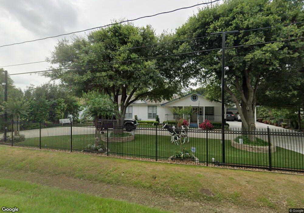
2901 Brownie Campbell Rd Houston, TX 77038
North Houston NeighborhoodEstimated Value: $352,481 - $1,438,000
4
Beds
2
Baths
2,088
Sq Ft
$346/Sq Ft
Est. Value
About This Home
This home is located at 2901 Brownie Campbell Rd, Houston, TX 77038 and is currently estimated at $722,827, approximately $346 per square foot. 2901 Brownie Campbell Rd is a home located in Harris County with nearby schools including Kujawa EC/Pre-K/K School, Wilson Intermediate School, and Shotwell Middle School.
Ownership History
Date
Name
Owned For
Owner Type
Purchase Details
Closed on
Jan 29, 2024
Sold by
Martinez Johnathan Alexi
Bought by
Martinez Johnathan Alexi and Martinez Henry Porfirio
Current Estimated Value
Purchase Details
Closed on
Feb 1, 2023
Sold by
Martinez Porfirio and Martinez Martha D
Bought by
Martinez Johnathan Alexi
Purchase Details
Closed on
Nov 15, 1999
Sold by
Moreno Francisco R and Moreno Christina C
Bought by
Martinez Porfirio and Martinez Martha Dolores
Create a Home Valuation Report for This Property
The Home Valuation Report is an in-depth analysis detailing your home's value as well as a comparison with similar homes in the area
Home Values in the Area
Average Home Value in this Area
Purchase History
| Date | Buyer | Sale Price | Title Company |
|---|---|---|---|
| Martinez Johnathan Alexi | -- | None Listed On Document | |
| Martinez Johnathan Alexi | -- | None Listed On Document | |
| Martinez Porfirio | -- | Texas American Title Company |
Source: Public Records
Tax History Compared to Growth
Tax History
| Year | Tax Paid | Tax Assessment Tax Assessment Total Assessment is a certain percentage of the fair market value that is determined by local assessors to be the total taxable value of land and additions on the property. | Land | Improvement |
|---|---|---|---|---|
| 2025 | $3,816 | $281,905 | $174,740 | $107,165 |
| 2024 | $3,816 | $288,504 | $190,311 | $98,193 |
| 2023 | $3,231 | $244,350 | $124,567 | $119,783 |
| 2022 | $4,676 | $258,007 | $124,567 | $133,440 |
| 2021 | $4,456 | $222,614 | $95,156 | $127,458 |
| 2020 | $4,269 | $187,940 | $95,156 | $92,784 |
| 2019 | $4,288 | $180,273 | $98,616 | $81,657 |
| 2018 | $2,044 | $169,429 | $98,616 | $70,813 |
| 2017 | $3,449 | $169,429 | $98,616 | $70,813 |
| 2016 | $3,135 | $138,334 | $63,668 | $74,666 |
| 2015 | $2,392 | $127,477 | $55,363 | $72,114 |
| 2014 | $2,392 | $124,922 | $39,682 | $85,240 |
Source: Public Records
Map
Nearby Homes
- 2919 Sunwood Dr
- 13803 Bearwood Rd
- 12611 Landon Light Ln
- 2530 Woodtown Dr
- 2719 Magnolia Hill Trail
- 14003 Valley Grove Dr
- 13308 Ann Louise Rd
- 2322 Hadden Hollow Dr
- 10915 Meadow Walk Ln
- 3240 Brownie Campbell Rd
- 2831 Oakland Brook St
- 2835 Oakland Brook St
- 2811 Oakland Brook St
- 2410 Irish Spring Dr
- 2838 Packard Elm St
- 14118 Magnolia Springs Dr
- 2315 Tomlinson Trail Dr
- 2222 Irish Spring Dr
- 2614 Lemonwood Ln
- 2606 Owens Cross Dr
- 2905 Brownie Campbell Rd
- 2817 Brownie Campbell Rd
- 2813 Brownie Campbell Rd
- 2805 Brownie Campbell Rd
- 2913 Brownie Campbell Rd
- 2803 Brownie Campbell Rd
- 2917 Brownie Campbell Rd
- 2912 Brownie Campbell Rd
- 3007 Brownie Campbell Rd
- 2717 Brownie Campbell Rd
- 3002 Brownie Campbell Rd
- 13610 Sundale Rd
- 3011 Brownie Campbell Rd
- 2923 Sunwood Dr
- 2927 Sunwood Dr
- 2915 Sunwood Dr
- 2931 Sunwood Dr
- 2911 Sunwood Dr
- 2907 Sunwood Dr
- 3018 Brownie Campbell Rd