
Seller's Agent in 2025
Lauren Baust
Joyner Fine Properties
(757) 589-9612
4 in this area
81 Total Sales
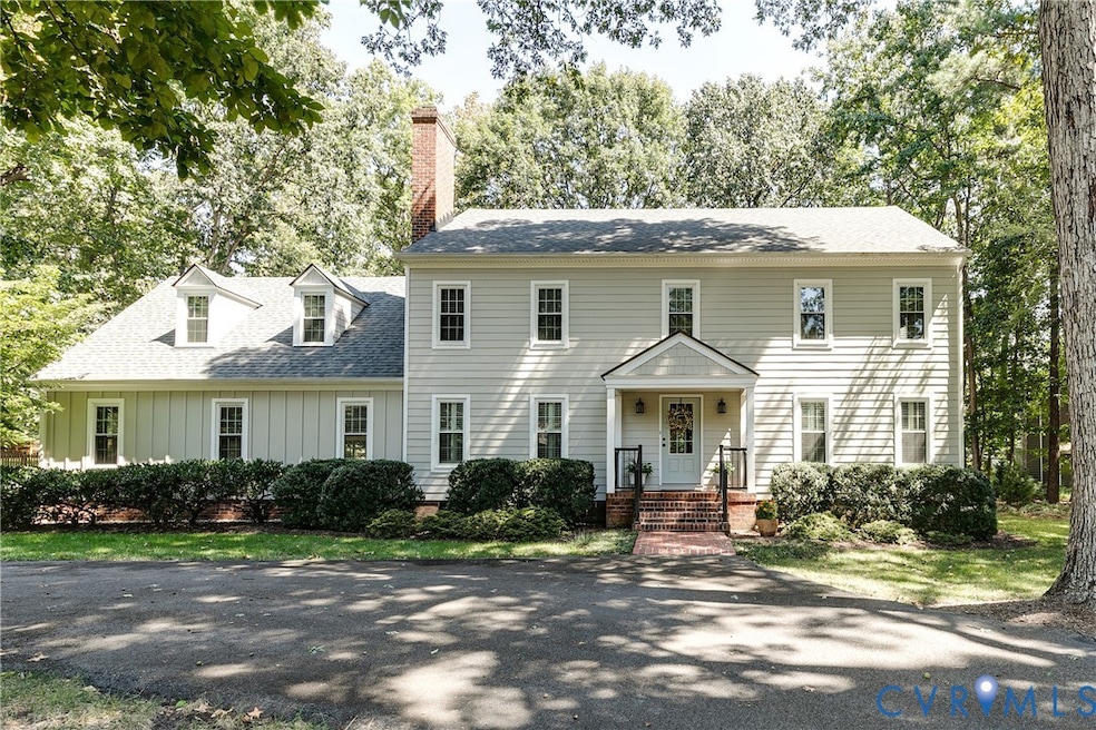


Welcome to 2901 Mount Hill Dr — a stunning 5bd, 2.5ba home on a spacious .95-acre corner lot in the highly desirable Salisbury neighborhood of Midlothian, VA. With 2,956 sq/ft. of living space, this home perfectly balances comfort and style along with plenty of room to grow.
The updated kitchen offers modern ss appliances, generous cabinetry, and a bright breakfast nook overlooking the private backyard. The family room flows seamlessly into the dining area, creating the ideal space for gatherings and entertaining.
Upstairs, the large primary suite boasts a spa-like bathroom with dual vanities, huge tiled shower, and a walk-in closet. Four additional well-sized bedrooms provide space for guests, playroom, gym, or a home office.
Outside, the nearly one-acre lot offers endless possibilities — from outdoor entertaining to gardening or simply relaxing in a peaceful setting. A two-car garage, ample storage, and easy access to top-rated Midlothian schools, parks, and major highways make this a rare find.
Living in Salisbury means more than just owning a home — it’s being part of a vibrant, established community known for its tree-lined streets, access to Salisbury Country Club, and convenient location close to shopping, dining, and everything Midlothian has to offer.
Don’t miss your chance to call Salisbury home — schedule your showing today!
Last Agent to Sell the Property
Joyner Fine Properties License #0225206350 Listed on: 09/09/2025
| Date | Type | Sale Price | Title Company |
|---|---|---|---|
| Bargain Sale Deed | $764,900 | First American Title Insurance | |
| Interfamily Deed Transfer | -- | None Available | |
| Warranty Deed | $430,000 | -- | |
| Deed | $264,900 | -- |
| Date | Status | Loan Amount | Loan Type |
|---|---|---|---|
| Open | $364,900 | New Conventional | |
| Previous Owner | $344,000 | New Conventional | |
| Previous Owner | $238,410 | New Conventional |
| Date | Event | Price | List to Sale | Price per Sq Ft |
|---|---|---|---|---|
| 10/15/2025 10/15/25 | Sold | $764,900 | 0.0% | $259 / Sq Ft |
| 09/18/2025 09/18/25 | Pending | -- | -- | -- |
| 09/09/2025 09/09/25 | For Sale | $764,900 | -- | $259 / Sq Ft |
| Year | Tax Paid | Tax Assessment Tax Assessment Total Assessment is a certain percentage of the fair market value that is determined by local assessors to be the total taxable value of land and additions on the property. | Land | Improvement |
|---|---|---|---|---|
| 2025 | $5,359 | $599,300 | $131,000 | $468,300 |
| 2024 | $5,359 | $563,300 | $111,000 | $452,300 |
| 2023 | $4,854 | $533,400 | $106,000 | $427,400 |
| 2022 | $4,691 | $509,900 | $103,000 | $406,900 |
| 2021 | $4,477 | $464,300 | $101,000 | $363,300 |
| 2020 | $4,260 | $448,400 | $101,000 | $347,400 |
| 2019 | $4,260 | $448,400 | $101,000 | $347,400 |
| 2018 | $4,082 | $429,000 | $101,000 | $328,000 |
| 2017 | $4,038 | $415,400 | $100,000 | $315,400 |
| 2016 | $3,922 | $408,500 | $96,000 | $312,500 |
| 2015 | $3,812 | $394,500 | $96,000 | $298,500 |
| 2014 | $3,642 | $376,800 | $96,000 | $280,800 |
Seller's Agent in 2025
Lauren Baust
Joyner Fine Properties
(757) 589-9612
4 in this area
81 Total Sales
L
Buyer's Agent in 2025
Logan Miller
Joyner Fine Properties
(804) 617-3300
1 in this area
4 Total Sales
Source: Central Virginia Regional MLS
MLS Number: 2525248
APN: 726-72-08-61-000-000
Disclaimer: Certain information contained herein is derived from information provided by parties other than Homes.com. All information provided is deemed reliable, but is not guaranteed to be accurate and should be independently verified.
![]() All or a portion of th multiple Listing information is provided by the Central Virginia Regional Multiple Listing Service, LLC, from a copyrighted compilation of Listing s. All CVR MLS information provided is deemed reliable but is not guaranteed accurate. The compilation of Listings and each individual Listing are ©2026 Central Virginia Regional Multiple Listing Service, LLC. All rights reserved.
All or a portion of th multiple Listing information is provided by the Central Virginia Regional Multiple Listing Service, LLC, from a copyrighted compilation of Listing s. All CVR MLS information provided is deemed reliable but is not guaranteed accurate. The compilation of Listings and each individual Listing are ©2026 Central Virginia Regional Multiple Listing Service, LLC. All rights reserved.
Ask me questions while you tour the home.