
Seller's Agent in 2025
Kelly Haines-Wise
Cummings & Co. Realtors
(410) 823-0033
1 in this area
13 Total Sales
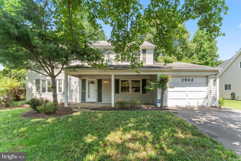
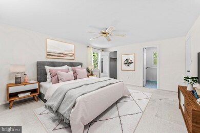
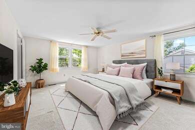
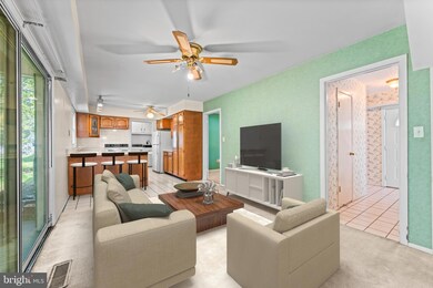

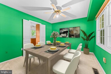

Welcome to 2902 Stonybrook Dr, where charm meets opportunity! Nestled in a peaceful, well-established neighborhood, this spacious 3-bedroom, 2.5-bathroom home is brimming with potential for buyers eager to create their dream space. Inside, you'll find 3 generously sized bedrooms, including a primary room with immensely valuable features—an ensuite plus 2 walk-in closets! The main level boasts several inviting living areas, including formal living and dining rooms, a large yet cozy feeling family room with a wood-burning stove, and a kitchen with easy access to the backyard through the glass sliding door. Once you step outside to the fenced-in backyard you’ll see that it is perfect for pets, entertaining, and relaxing under the covered patio. The 1-car garage with access to the home adds convenience. With its timeless Levitt Colonial layout, this home offers the perfect canvas for modern updates. This is the home you’ve been waiting for to bring your vision to life by adding your personal touches and to make it truly your own! Don’t miss this exciting opportunity to own a home in Bowie that’s ready for your creativity. Schedule your showing today!
Last Agent to Sell the Property
(410) 823-0033 realtor@cummingsrealtors.com Cummings & Co. Realtors Listed on: 07/03/2025
| Date | Type | Sale Price | Title Company |
|---|---|---|---|
| Deed | $450,000 | Counsel Title | |
| Deed | $450,000 | Counsel Title | |
| Deed | $287,500 | -- | |
| Deed | $154,000 | -- |
| Date | Status | Loan Amount | Loan Type |
|---|---|---|---|
| Open | $6,000 | No Value Available | |
| Closed | $6,000 | No Value Available | |
| Open | $436,500 | New Conventional | |
| Closed | $436,500 | New Conventional | |
| Previous Owner | $150,000 | Purchase Money Mortgage |
| Date | Event | Price | List to Sale | Price per Sq Ft |
|---|---|---|---|---|
| 07/28/2025 07/28/25 | Sold | $450,000 | +1.1% | $250 / Sq Ft |
| 07/09/2025 07/09/25 | Pending | -- | -- | -- |
| 07/03/2025 07/03/25 | For Sale | $445,000 | -- | $247 / Sq Ft |
| Year | Tax Paid | Tax Assessment Tax Assessment Total Assessment is a certain percentage of the fair market value that is determined by local assessors to be the total taxable value of land and additions on the property. | Land | Improvement |
|---|---|---|---|---|
| 2025 | $5,879 | $406,100 | $126,400 | $279,700 |
| 2024 | $5,879 | $382,433 | -- | -- |
| 2023 | $6,119 | $358,767 | $0 | $0 |
| 2022 | $5,684 | $335,100 | $101,400 | $233,700 |
| 2021 | $5,382 | $318,333 | $0 | $0 |
| 2020 | $5,089 | $301,567 | $0 | $0 |
| 2019 | $4,819 | $284,800 | $100,700 | $184,100 |
| 2018 | $4,589 | $270,467 | $0 | $0 |
| 2017 | $4,368 | $256,133 | $0 | $0 |
| 2016 | -- | $241,800 | $0 | $0 |
| 2015 | -- | $238,567 | $0 | $0 |
| 2014 | $3,805 | $235,333 | $0 | $0 |
Seller's Agent in 2025
Kelly Haines-Wise
Cummings & Co. Realtors
(410) 823-0033
1 in this area
13 Total Sales
Buyer's Agent in 2025
Vah Coulibaly
HomeSmart
(240) 432-7279
1 in this area
35 Total Sales
Source: Bright MLS
MLS Number: MDPG2157154
APN: 07-0659516
Disclaimer: Certain information contained herein is derived from information provided by parties other than Homes.com. All information provided is deemed reliable, but is not guaranteed to be accurate and should be independently verified.
![]() The data relating to real estate for sale on this website appears in part through the BRIGHT Internet Data Exchange program, a voluntary cooperative exchange of property listing data between licensed real estate brokerage firms, and is provided by BRIGHT through a licensing agreement.
The data relating to real estate for sale on this website appears in part through the BRIGHT Internet Data Exchange program, a voluntary cooperative exchange of property listing data between licensed real estate brokerage firms, and is provided by BRIGHT through a licensing agreement.
Listing information is from various brokers who participate in the Bright MLS IDX program and not all listings may be visible on the site.
The property information being provided on or through the website is for the personal, non-commercial use of consumers and such information may not be used for any purpose other than to identify prospective properties consumers may be interested in purchasing.
Some properties which appear for sale on the website may no longer be available because they are for instance, under contract, sold or are no longer being offered for sale.
Property information displayed is deemed reliable but is not guaranteed.
Copyright 2026 Bright MLS, Inc.
Ask me questions while you tour the home.