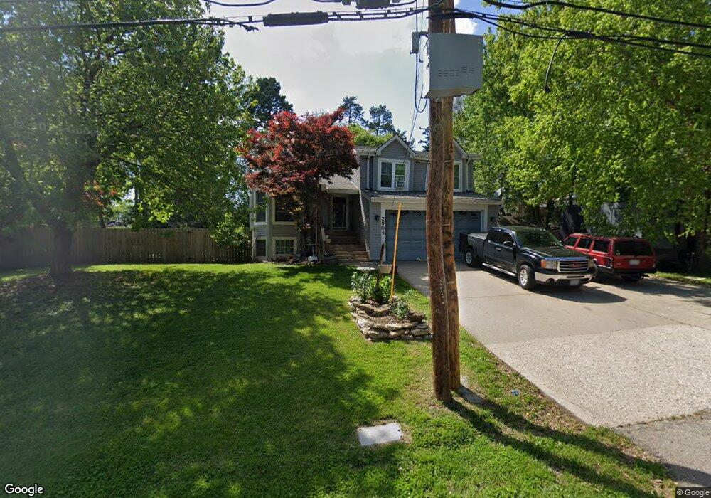
2904 N 31st St Saint Joseph, MO 64506
Ashland NeighborhoodEstimated Value: $251,091 - $329,000
--
Bed
--
Bath
1,510
Sq Ft
$198/Sq Ft
Est. Value
About This Home
This home is located at 2904 N 31st St, Saint Joseph, MO 64506 and is currently estimated at $299,523, approximately $198 per square foot. 2904 N 31st St is a home located in Buchanan County with nearby schools including Field Elementary School, Bode Middle School, and Central High School.
Ownership History
Date
Name
Owned For
Owner Type
Purchase Details
Closed on
Mar 18, 2016
Sold by
Long Andre W and Long Misty Renee
Bought by
Long Andre W and Long Misty Renee
Current Estimated Value
Home Financials for this Owner
Home Financials are based on the most recent Mortgage that was taken out on this home.
Original Mortgage
$209,000
Outstanding Balance
$165,423
Interest Rate
3.65%
Mortgage Type
VA
Estimated Equity
$134,100
Purchase Details
Closed on
Sep 18, 2013
Sold by
Borger Erik A and Borger Lesley
Bought by
Long Andre W
Home Financials for this Owner
Home Financials are based on the most recent Mortgage that was taken out on this home.
Original Mortgage
$159,000
Interest Rate
4.45%
Mortgage Type
VA
Purchase Details
Closed on
Aug 31, 2009
Sold by
Borger Andrew A
Bought by
Borger Andrew A and Borger Erik A
Create a Home Valuation Report for This Property
The Home Valuation Report is an in-depth analysis detailing your home's value as well as a comparison with similar homes in the area
Home Values in the Area
Average Home Value in this Area
Purchase History
| Date | Buyer | Sale Price | Title Company |
|---|---|---|---|
| Long Andre W | -- | -- | |
| Long Andre W | -- | First American Title | |
| Borger Andrew A | -- | None Available |
Source: Public Records
Mortgage History
| Date | Status | Borrower | Loan Amount |
|---|---|---|---|
| Open | Long Andre W | $209,000 | |
| Closed | Long Andre W | $159,000 |
Source: Public Records
Tax History Compared to Growth
Tax History
| Year | Tax Paid | Tax Assessment Tax Assessment Total Assessment is a certain percentage of the fair market value that is determined by local assessors to be the total taxable value of land and additions on the property. | Land | Improvement |
|---|---|---|---|---|
| 2024 | $2,471 | $34,590 | $4,490 | $30,100 |
| 2023 | $2,471 | $34,590 | $4,490 | $30,100 |
| 2022 | $2,280 | $34,590 | $4,490 | $30,100 |
| 2021 | $2,290 | $34,590 | $4,490 | $30,100 |
| 2020 | $2,276 | $34,590 | $4,490 | $30,100 |
| 2019 | $2,199 | $34,590 | $4,490 | $30,100 |
| 2018 | $1,985 | $34,590 | $4,490 | $30,100 |
| 2017 | $1,966 | $34,590 | $0 | $0 |
| 2015 | $0 | $34,590 | $0 | $0 |
| 2014 | $2,150 | $34,490 | $0 | $0 |
Source: Public Records
Map
Nearby Homes
- 3028 Ashland Ave
- 3128 Floral Ave
- 3015 Miller Rd
- 2519 Forest Ave
- 3004 C Garden Gate N A N
- 3815 Miller Rd
- 3315 Chatham Ave
- 3326 Chatham Ave
- 00 Lot 2 Highway 169
- 00 Lot 1 Highway 169
- 3111 N 35th St
- 3412 N 35th Place
- 2110 Ashland Ave
- 4411 Rochester Rd
- 2906 Cook Rd
- 4301 N 169 Hwy
- 3103 Cook Rd
- 2102 N 34th Terrace
- 3208 Arbor Lake Dr
- 2211 Lovers Ln
- 3020 Summit Ave
- 3027 Dale Ave
- 3102 Summit Ave
- 3016 Summit Ave
- 3101 Dale Ave
- 0 N 31st St Unit 1893013
- 3106 Summit Ave
- 3107 Dale Ave
- 2903 Ashland Ave
- 2923 Ashland Ave
- 3011 Summit Ave
- 3102 Dale Ave
- 2812 N 31st St
- 3108 Summit Ave
- 3115 Dale Ave
- 3101 Summit Ave
- 3026 Dale Ave
- 3024 Dale Ave
- 3003 Ashland Ave
- 3105 Summit Ave