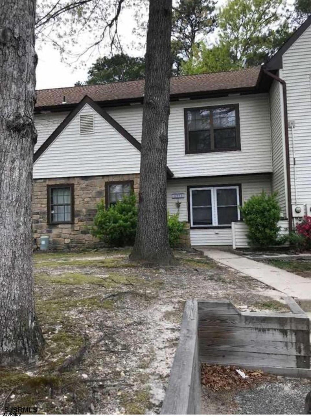


2904 Woodlands Dr Mays Landing, NJ 08330
Estimated payment $1,655/month
Highlights
- Walk-In Closet
- Patio
- Central Air
- Cedar Creek High School Rated A-
- Laundry Room
- Dining Room
About This Home
COME SEE THIS BEAUTIFULLY DONE 3 BED 2.5 BATH TOWNOUSE. NEWER HEATER, STOVE, REFRIGERATOR AND AIR UNIT( WITHIN PAST FEW YEARS) PERFECT FOR INVESTORS AS THERE IS A RENTER IN PLACE WITH A LEASE UNTIL APRIL 2026 GREAT TENANT WHO WANTS TO STAY WITH GUARANTEED RENT AT $2700 PER MONTH!!!! GOOD LOCATION NEAR SHOPPING AND GREAT SCHOOLS. ALL PICS ARE BEFORE TENANT MOVED IN MAY 2025
Home Details
Home Type
- Single Family
Est. Annual Taxes
- $2,837
Home Design
- Slab Foundation
- Vinyl Siding
Interior Spaces
- Dining Room
- Laminate Flooring
Kitchen
- Self-Cleaning Oven
- Dishwasher
Bedrooms and Bathrooms
- 3 Bedrooms
- Walk-In Closet
Laundry
- Laundry Room
- Dryer
- Washer
Home Security
- Storm Screens
- Carbon Monoxide Detectors
- Fire and Smoke Detector
Parking
- Shared Driveway
- Assigned Parking
Outdoor Features
- Patio
Utilities
- Central Air
- Heating Available
- Electric Water Heater
Listing and Financial Details
- Tax Lot 25
Map
Home Values in the Area
Average Home Value in this Area
Tax History
| Year | Tax Paid | Tax Assessment Tax Assessment Total Assessment is a certain percentage of the fair market value that is determined by local assessors to be the total taxable value of land and additions on the property. | Land | Improvement |
|---|---|---|---|---|
| 2025 | $2,062 | $80,600 | $25,000 | $55,600 |
| 2024 | $2,062 | $60,100 | $10,000 | $50,100 |
| 2023 | $1,939 | $60,100 | $10,000 | $50,100 |
| 2022 | $1,939 | $60,100 | $10,000 | $50,100 |
| 2021 | $1,774 | $55,100 | $5,000 | $50,100 |
| 2020 | $1,774 | $55,100 | $5,000 | $50,100 |
| 2019 | $1,778 | $55,100 | $5,000 | $50,100 |
| 2018 | $1,716 | $55,100 | $5,000 | $50,100 |
| 2017 | $1,689 | $55,100 | $5,000 | $50,100 |
| 2016 | $1,641 | $55,100 | $5,000 | $50,100 |
| 2015 | $1,586 | $55,100 | $5,000 | $50,100 |
| 2014 | $1,736 | $66,100 | $7,000 | $59,100 |
Property History
| Date | Event | Price | List to Sale | Price per Sq Ft |
|---|---|---|---|---|
| 11/17/2025 11/17/25 | For Sale | $270,000 | -- | -- |
Purchase History
| Date | Type | Sale Price | Title Company |
|---|---|---|---|
| Deed | $170,000 | -- | |
| Bargain Sale Deed | $115,000 | Independence Abstract & Titl |
Mortgage History
| Date | Status | Loan Amount | Loan Type |
|---|---|---|---|
| Open | $161,000 | Purchase Money Mortgage | |
| Previous Owner | $103,500 | Fannie Mae Freddie Mac |
Source: South Jersey Shore Regional MLS
MLS Number: 602554
APN: 12-01135-15-00025-0000-C0025
Disclaimer: Certain information contained herein is derived from information provided by parties other than Homes.com. All information provided is deemed reliable, but is not guaranteed to be accurate and should be independently verified.
![]() IDX information is provided exclusively for personal, non-commercial use, and may not be used for any purpose other than to identify prospective properties consumers may be interested in purchasing.
IDX information is provided exclusively for personal, non-commercial use, and may not be used for any purpose other than to identify prospective properties consumers may be interested in purchasing.
Information is deemed reliable but not guaranteed.
© 2025 South Jersey Shore Regional Multiple Listing Service. All rights reserved.
- 2731 Mimosa Ct
- 2728 Mimosa Ct Unit 445
- 2725 Mimosa Ct
- 2723 Mimosa Ct
- 3017 Ivy Bush Ct Unit 3017
- 3054 Ivy Bush Ct Unit 515
- 2818 Hawthorn Ct Unit 2818
- 2626 Nutmeg Ct Unit 385
- 2501 Oleander Ct Unit 3412
- 2418 Primrose Ct
- 3110 Woodlands Dr
- 2340 Primrose Ct
- 2614 Dogwood Ct Unit 2614
- 2127 Rhododendron Ct Unit 25
- 3137 Woodlands Dr Unit 3137
- 2123 Rhododendron Ct Unit 57B
- 3514 Woodlands Dr Unit 51
- 4406 Yorktown Place
- 4455 Yorktown Place Unit 28
- 4505 Concord Place Unit K86
- 2744 Mimosa Ct
- 2839 Forsythia Ct Unit 277
- 3214 Juniper Ct Unit 652
- 3137 Woodlands Dr Unit C0025
- 2465 Arbor Ct Unit 311
- 2444 Bayberry Ct
- 1932 Cologne Ave
- 3307 Falcon Ct
- 2000 Timber Glen Dr
- 4788 Summersweet Dr Unit EE251
- 4850 Corwen Ct
- 6020 Delilah Rd
- 9 Del Ray Rd Rd
- 1000 Bally Bunion Dr
- 4 Millard Ave
- 611 Country Club Dr
- 108 Pico Ct Unit 1H
- 254 Vail Ct Unit 1504
- 254 Vail Ct
- 519 S English Creek Rd
